The information provided in this guide is not intended to amount to legal advice. Professional assistance may be required to determine the most appropriate action to protect your legal rights. Please read our Terms of Use on the Strata Titles Policy and Procedure Guides web page. Landgate accepts no responsibility where parties print this guide and seek to rely on information that is out of date.
Contents
1. Scheme Plan (section 32 STA)
1.1. Surveys of Strata and Survey-Strata Plans
1.3. Surveys of Survey-Strata Plans
1.10. Measurement Presentation
1.14. Enlargements and Displaced Data
1.17. Schedule of Interests and Notifications
1.19. Depth Limits and Crown Allotment Boundaries
1.20.1. Reservations in Crown Grants
1.20.2. Lands Affected by Section 15 of the Public Works Act 1902
1.20.3. Mineral Reservations in Transfers
1.22. Automatic Road Dedications
1.23. Restricted Use Condition
2.1. Components of a Strata Plan
2.3. Offsets, Easements over Encroachments and Easements of Support
2.8. Large Plans (Rural or Staged)
3. Drafting of Survey-Strata Plans
3.3. Certificate of Verifying Surveyor
3.5.1. Encroachments, Building Connections
3.6. Easements and Restrictive Covenants
3.6.2. Easements That do not meet the terms in the Tenth Schedule of the TLA
4. Requirements for Registration of a Scheme Plan
4.1. Permit Authority Certification
4.2. Requirements for Building Act Forms
4.4. Cancellation of a Strata/Survey-Strata Plan
4.5. Requirements for Registration of Amendment of a Scheme Plan (section 35 STA)
4.5.1. Type 1(a) Subdivision - Addition of Common Property from Outside the Parcel
4.6. Plans Required for Type 1 (a) Subdivisions
4.7. Type 1(b) Subdivision - Conversion of Lot/s Within a Scheme to Common Property
4.8. Type 2 Subdivision - Transfer of Common Property
5.1. Permit Authority Certificate
5.2. Type 3 Subdivision - Consolidation of Lots
5.3. Type 4 Subdivision - Re-subdivision of Strata Titles Schemes
5.7. Permit Authority Certificate
5.9. Significant Variations on Staged Schemes
6. Amendment of scheme plan not effecting subdivision
7. Purchase and amalgamation of closed roads or crown land
8. Plan requirements for amalgamation of closed public road or other crown land
9. Amalgamation of closed closed private roads or ways
1. Scheme Plan - section 32 Strata Titles Act 1985 (STA)
A scheme plan for a strata titles scheme means the strata plan or survey-strata plan registered, or proposed to be registered, for the strata titles scheme as a scheme document. Unlike plans and diagrams deposited under the Transfer of Land Act 1893 (TLA), strata and survey-strata plans become part of the land register and once registered, cannot be varied or terminated without due registration procedures. It is therefore important that accurate information be incorporated into both the survey and the drafting components of any scheme plan. The land identified by a scheme plan must be comprised of a single lot on a plan lodged at Landgate and be the subject of a certificate of title.
A Scheme Plan must:
- specify the address of the land subdivided by the scheme; and
- identify the title to the land subdivided by the scheme; and
- specify whether the scheme is a strata scheme or a survey-strata scheme
- if it is a strata scheme – it must consist of a location plan and a floor plan;
- if it is a survey-strata scheme – consist of a survey plan of the land subdivided by the scheme; and
- identify each lot in the scheme with a unique number; and
- define the boundaries of each lot; and
- delineate any land that is to vest in the Crown under Sec 152 of the Planning and Development Act 2005 (P&D Act); and
- delineate areas that are roads, or are to be new roads created by Sec 168 of the P&D Act; and
- if it is a strata scheme, identify the nature and extent of any part of a wall or building or material attached to a wall or building that encroaches on land outside the parcel
- if an encroachment is to be controlled by and managed as if it were common property or part of a lot, the plan must specify that fact (regulation 15 of the Strata Titles (General) Regulations 2019 (ST(G)R); and
- if an encroachment is to be subject to an easement, specify that easement.
A scheme plan for a survey-strata scheme may create a lot as a cubic space lot (limited in height and depth) only if the balance of the land above and below the lot is common property.
1.1. Surveys of Strata and Survey-Strata Plans
A strata company may add land from outside the parcel to the common property of the scheme by purchasing adjoining land or a lot within the scheme.his constitutes a type 1(a) subdivision of a strata titles scheme. The additional contiguous land may then become a lot or part of a lot by either a type 4 subdivision (re-subdivision) or merger/conversion to survey-strata (for schemes registered before 1 January 1998) depending on the date when the scheme plan was registered.The survey requirements for each plan type are different because of the variation in the type of development. Consequently, many of the decisions in regard to referencing, pegging and marking rely on the surveyor’s professional judgement. There are, however, regulations in place for the responsibility, accountability and consequences of certification under the Licensed Surveyors Act 1909 (LSA).Surveyors should note that each plan type has different survey requirements because a Strata Plan relates mainly to “monuments” and a Survey-Strata Plan relates mainly to survey measurements.The surveyor must sign a certificate (Regulation 54 of the Licensed Surveyors (General Surveying Practice) Regulations 1961) which certifies that the plan is accurate and a correct representation of the survey and calculations from measurements recorded in field notes and that it also complies with the relevant written laws and regulations in relation to which the plan is lodged.
1.2. Surveys of Strata Plans
Surveys for strata plans require re-establishment of the parcel boundaries (based on rigorous pickup as for TLA subdivisions), followed by the positioning of the buildings and part lots that are external to the building or buildings.On the occasions where significant excess or any deficiency is discovered during a re-establishment survey a field book needs to be lodged. If necessary, the surveyor may lodge a “Redefinition Plan” to show the correct dimensions and area and an application for a new title can be made. A “Redefinition Plan” is necessary when the differences are outside the ‘margin of error’ covered by section 155 of the TLA.Connections of buildings to the boundary of the parcel should be to cadastral re-establishment standard. Street corners used for pickup should be referenced or protected and it is prudent to place a strategic reference mark near the scheme.Survey work performed on a strata plan can result in a combination of measurements, monuments and height dimensions to define the horizontal and vertical lot boundaries. As a strata plan is an authorised survey and Regulation 8(2C) of the Licensed Surveyors (General Surveying Practice)Regulations 1961 requires a field record to be lodged with the plan of the authorised survey, a field record must be lodged for:
- all new strata plans
- type 1 subdivision (adding land from outside the parcel to the common property and converting a lot within a scheme to common property)
- type 2 subdivision (removal of common property from the parcel)
- type 3 subdivision (consolidation of lots)
- type 4 subdivisions (re-subdivisions) and
- mergers
Connections to standard survey marks may need to be made in accordance with guidelines under regulation 22A of the Licensed Surveyors (General Surveying Practice) Regulations, 1961.It is recommended that strata be related to Australian Height Datum (AHD) wherever practical, especially in larger schemes, staged schemes and vacant lot schemes. Maintenance of views is an emotive issue, and there is potential for confusion or mistake when building construction extends over several years and involves more than one surveyor – a problem which is overcome if AHD is used as standard practice.
1.3. Surveys of Survey-Strata Plans
The survey for a survey-strata plan (as well as a strata plan) is an authorised survey as defined in the Licensed Surveyors Act 1909 (LSA). It (the survey) must be carried out by a licensed surveyor with a current practising certificate. A survey-strata plan needs to be certified by a surveyor eligible to verify survey documents (see section 3.3 of this guide).Surveyors should note that the certification of a survey-strata plan is similar in content and therefore in responsibility, accountability and consequences to that of a certification under the LSA. The surveyor certifies to the correctness and to compliance with the regulations, and the significance of that must not be overlooked.Surveys for survey-strata schemes of more than 10 serviced lots where roads are created, or where areas of common property are used as roads, must be lodged in accordance with the Special Survey Area (SSA) guidelines (available from www.lslb.wa.gov.au/) (see Plan Example 44).Surveys for a survey-strata scheme within an existing SSA must be lodged in accordance with the SSA guidelines: i.e. lodge a field record and not a Survey Sheet (see SSA guideline 10.0).The following guidelines apply to both new survey-strata schemes and conversions to survey-strata under Schedule 2A of the STA.The survey for a survey-strata plan should be to a standard equivalent to that for a TLA survey. This enables it to be used for re-establishment of later adjacent or nearby TLA surveys (and it should be considered by any later TLA survey).A survey for a survey-strata plan should comply with the regulations under the LSA and TLA and specifically those dealing with:
- pegging or other marking of lot corners and boundaries for the public
- referencing of lot corners
- accuracy
and
- recording of field notes.
The surveyor should be guided by the Survey and Plan Policy and Procedure Guides, particularly SPP-03 and SPP-04.Connections to standard survey marks may need to be made in accordance with guidelines under Regulation 22A of the Licensed Surveyors (General Surveying Practice) Regulations, 1961.Digital data (CSD file) is required with each survey-strata plan for examination purposes and integration into the cadastre. All lots should be captured as freehold lots. Easements and 3-dimensional lots are to be captured in two dimensions (plan view) only.
- On large survey-strata schemes, common property used as a road should be referenced as required for roads by the general survey regulations or guidelines.
- Regulation 24A of the Licensed Surveyors (General Surveying Practice) Regulations 1961 and TLA survey regulations 23, 32 and 35, dealing with protection of pickup, apply equally to survey-strata schemes.
- In numbering the pegs of a survey-strata plan, the “CP” prefix should be included on common property areas.
- All new lot corners must be pegged, marked with non-standard marks or noted why they cannot be marked ie “Corner Inaccessible’.
- Existing parcel corners where not marked are considered to be original.
If the survey-strata plan creates lots that are limited in height and/or depth, those limits must be related to AHD, and a connection should also be made to a physical reference datum on or near the site. This height reference mark should be recorded in the field record (see Plan Example 4 and Plan Example 29).This AHD requirement also applies to “intrusion easements”. The AHD is to be applied to a stated surface, i.e. a floor level of a building or ground level on the scheme or a SSM or Water Corporation Manhole adjacent to the scheme, on a cross sectional drawing to define the area of intrusion (see Plan Example 10).
1.4. Common Guidelines
Many guidelines for drafting apply to all scheme plans under the STA, including:
- strata plans
- survey-strata plans
- merger sketch plans
- plan of conversion to survey-strata
- scheme plans of type 1 subdivision (inclusion of common property)
- scheme plans of type 2 subdivision (disposal of common property), and
- scheme plans of type 3 subdivision (consolidation), and
- scheme plans of type 4 subdivision (re-subdivision)
For convenience, these common guidelines are recorded in this chapter.For easier recognition by users, it has been attempted to achieve uniformity in drafting practices and conventions between TLA plans and STA plans. The more commonly used conventions have been recorded in this chapter, but not those which are rarely needed.Where a topic is not covered by these guidelines, it is suggested that there may be appropriate guidance in the Survey and Plan Policy and Procedure Guide.
1.5. Drafting Requirements
As each development can differ, practitioners should use their professional judgment to produce a clear unambiguous product.All plans must clearly show the vertical and horizontal boundaries of each lot by either dimension or notation. Past confusion of lot boundaries on plans registered before the Strata Titles Amendments Act 1995 could have been avoided if the information for lot definition had been clearly and simply depicted on the plan. This aspect of strata practice is increasing in importance as lot owners and purchasers become more discerning.The compulsory disclosure requirements on the sale of strata properties (see Guide to Strata Titles) make it essential that lot boundaries are clearly identified. The STA requires the buyer be given a copy of the scheme plan before the buyer signs the contract for sale. All information in relation to lot boundaries should be clearly identified. Cross sections and enlargements are encouraged to illustrate complex boundaries.Buyers must be notified of any changes to the plan, or proposed plan, as a sale may be avoided if this information is not provided.
1.5.1. Scale
An appropriate metric representative fraction should be chosen and must be sufficiently large to enable all detail to be clear and legible. Because strata plans and survey-strata plans are photo-reduced for search purposes, a graphical (bar) scale is to be shown on the plan. This should be a basic scale bar drawn as a single line with the appropriate divisions.
1.6. Plan Forms and Use
All plans (including types 1 – 4 subdivisions and mergers lodged for registration are required to include a version/ amendment schedule, the same as shown on deposited plans.A company stamp or logo may be placed on the plan form. The stamp must not obscure detail on the plan.There is no limit to the number of lots that may be depicted on a strata or survey-strata plan, if there is sufficient space available, but a clear concise image must be able to be reproduced. A location and floor plan can be placed on the same sheet of a strata plan. Provided there is sufficient space, a schedule of unit entitlements and valuer’s certificate or the surveyor’s certificate may also be placed on the plan sheet.Electronic Lodgement is compulsory for all field records and scheme plans. Appendix 6 (APX-06) of the Survey and Plan Policy and Procedure Guides provides guidelines on the preparation and lodgement of electronic plans.To avoid or minimise enquiries being made at Landgate about unlodged plans and/or field books using pre-allocated numbers, surveyors should stamp, or otherwise indicate on any copy of a Plan provided to a client or conveyancer that the copy is an ‘unlodged version’.Pre-allocation provides settlement agents and lending institutions the opportunity to prepare their documents for registration prior to the scheme plan being lodged at Landgate.
1.7. Orientation
The orientation on scheme plans is to be indicated by a north point arrow and preferably should be approximately 70mm long. It is preferable that the north point be parallel to the side edge of the form, but the orientation may be rotated in order to incorporate a best scale. Preferably, the north point should not point generally downwards on the form. Location plans and floor plans must have the same orientation. All sheets of a survey-strata plan must be on the same orientation.
1.8. Line Styles
The line styles recommended below will ensure readability when scheme plans are printed or viewed at reduced size:
- Parcel boundary- 0.25mm
- Internal lot boundaries that are not monuments- 0.25mm
- Boundary lines that are monuments on strata plans- 0.5mm
- All lot boundaries on survey-strata plans- 0.25mm
- Crown allotment boundaries (required for depth limits only-) broken 0.35mm
and
- Easement boundaries- broken 0.25mm.
1.9. Text Styles
When preparing the scheme plan the below table should be used as a guide:Text Styles and Size
|
Lot numbers the subject of the plan |
3.5mm or 5mm |
Italic |
Pt 5 |
|
Areas |
2.5mm or 3.5mm |
Italic |
235m² |
|
Distances |
2.5mm |
Italic |
20.12 |
|
Angles |
2.5mm |
Upright |
97º 12’ 30” |
|
Easements/Interests Angles & Distances |
1.8mm |
Upright |
89° 59’ 50” 2.01 |
|
Abutting lot numbers |
2.5mm or 3.5mm |
Italic |
45 |
|
Abutting plans |
2.5mm or 3.5mm |
Upright |
D 56231 |
|
Street Names |
3.5mm |
Upright Upper Case |
HAY STREET |
|
Annotations |
2.5mm |
Upright Lower Case |
east face of wall |
|
Strata wordings |
2.5mm |
Upright Upper Case preferred |
THE STRATA OF |
|
Heading |
3.5mm |
Upright Upper Case |
LOT 2 ON DIAGRAM |
|
AHD levels |
2.5mm |
Upright Upper Case |
13.12m AHD |
The font used for these texts is to be of a type such that the first priority is optimum legibility of a reduced size copy. It should be an open style without serifs and with clear distinction between similar shaped figures and with a readily visible decimal point. The preferred font styles are Arial and Isocpeur.
1.10. Measurement Presentation
- Distances should be shown in metres to the nearest 0.01 metre or 0.001 metre.
- For distances less than one metre the decimal point should be preceded by a “0” (e.g. 0.75 not .75).
- “0” need not be shown as the last character of a length, to the right of the decimal point (e.g. 15.10 is expressed as 15.1 and 15.100 is also expressed as 15.1).
- Angles should be shown to the nearest second.
- Nil seconds or nil minutes and seconds need not be shown (e.g. 170º 0’0” is expressed as 170º, 170º11’0” is expressed as 170º11’).
1.11. Road Names
Road names to be shown on scheme plans should primarily be obtained from the street address information in MapViewer Plus on Landgate's website. This information can further be verified against the street centreline data that is also available in MapViewer Plus.In addition, the scanned images of the hard copy Survey Index Plans (SIP’s) can also be viewed via the MapViewer Plus, but it must be noted that maintenance of this series of plans no longer takes place. Road names must be easily recognised on the face of the plan.Surveyors are advised that, in the situation where an area of common property on a survey-strata plan is to be known by a street/road name approved by Landgate’s Geographic Names, the plan graphic should display the area of common property number only. A note should be placed on the sketch plan, outside the graphic, indicating the approved street/road name of the area of common property (see Plan Example 65). Certificates of Title issuing from the plan will show the allocated Property Street Address referring to the street/road name given to the area of common property.
1.12. Areas
- For areas less than 10,000 square metres, area is shown to the nearest square metre (e.g. 9446m²).
- For areas of 10,000 square metres or greater, area is shown in hectares to four decimal places (e.g. 9.2713 ha). “0” need not be shown as the last character of an area to the right of the decimal point (e.g. 6.4500 ha to be shown as 6.45 ha).
Areas are to be shown for each lot, part lot and area of common property shown on the plan. For part lots the total area of all the parts should also be shown (in brackets) within the main part lot, which is normally the part lot forming or comprised in the building in the case of a strata plan, or the largest part lot in the case of a survey-strata plan.
1.13. Abuttals
A scheme plan must show as abuttals the number of any abutting lots for which certificates of title have issued at the time of lodgement of that plan. Lots on plans that have been lodged but not yet approved (shown on “lodged layer” of SCDB) must not be shown as abuttals unless the surveyor provides evidence satisfactory to Landgate that lodgement of dealings for those lodged plans is imminent.The numbers of all current adjoining lots are to be shown with their plan numbers shown below them and prefixed P, D or DP. Where subdivisional plans were subdivided into sheets for convenience plan sheet numbers are to be included. E.g. P1234 (1). If the original plan is a multi-sheet ‘Deposited Plan’, the sheet number should not be included because any or all of the sheets may contain relevant information.If the abutting lot is the subject of a strata titles scheme, regardless whether it is a strata plan or a survey-strata plan, the number should be placed (in brackets and prefixed SP) under the lot number on the TLA plan number.Prior to 23 January 2004, abutting land coloured brown on surveys was generally labelled:"Private Appurtenant"or"Private Non-Appurtenant"depending on the circumstance. After this date the reference to implied rights could only be used when section 167A of the TLA applied.The following notes should be used as a guide to notations placed on strata/survey-strata plans:
- Abutting land coloured brown and labelled
“ROW”created on an adjoining survey is to be labelledand the survey number followed by “Coloured brown on Diagram/Plan”.Section 167A TLA does not apply.
- Abutting land coloured brown and labelled
“Road”or with a road name if one exists, created on an adjoining survey is to be labelled“Road”or the road name and the survey number followed by “Coloured brown on Diagram/Plan”.
- Abutting land coloured brown and unlabelled, created on an adjoining survey or on a parent survey will show the survey number followed by “Coloured brown on Diagram/Plan”.
Section 167A TLA does not apply (see Plan Example 14).
- Abutting vested PAW’s and ROW’s, whether created on the parent survey or not, are considered for public use and hence labelled. The creating survey number is also shown.
- Abutting land coloured brown and labelled
“ROW”created on the parent survey is to be labelled“ROW”.and the survey number followed by “Coloured brown on Diagram/Plan”Section 167A TLA does apply. This notation must be brought forward in the “Interests and Notifications” Schedule (see Plan example 10).
- Abutting land coloured brown and labelled
“ROAD”or with a road name if one exists, created on the parent survey is to be labelled“ROAD”or the road name and the survey number followed by “Coloured brown on Diagram/Plan”.- Abutting railway reserves are labelled“Railway”and the plan number shown.
- Abutting drain reserves are labelled
“Drain”and the plan number shown.In many country townsites, for example Kalgoorlie, there are many public undesignated accessways created on Crown survey plans. These are shown with the Plan number and designated ‘Public ROW’ in brackets.
1.14. Enlargements and Displaced Data
In order to maintain clarity or overcome a lack of space, enlargements or ticking in detail may be used. The ticked in detail should be parallel to the line in the case of a linear measure and on the half angle in the case of an angular measure. Enlargements need not be drawn to scale (see Plan Example 12).
1.15. Cross Sections
Cross-sections may be used to assist in clarifying lot boundaries. The sectional view must be identified on the plan view by lines of cut and referenced by alpha characters. The cross-section must reflect that cut. Horizontal boundaries must be referenced to a monument such as a floor, footing or AHD. The scale should be the same as for the floor plans and depiction of the cross-section should contain enough measurements to clearly establish the boundaries.On strata plans, the cross-section cut should be through the lots depicted on the floor plan. The cross-section is used to illustrate the horizontal boundaries of the lots (see Plan Example 7).The scale should be large enough to show all detail clearly and the drafting convention should follow architectural methods.Cross-sections on survey-strata plans can be used to depict the limits of the cubic space forming the lots and for illustrating the extent of easement limits. It is permissible to include the outline of the walls and other structural information so that a lay person can identify the boundaries (see Plan Example 14).
1.16. Easements
Easements created under section 136C of the TLA automatically on strata plans are shown on the floor plan sheet of the strata plan by broken lines. Where the easements are created over common property or outside buildings, they and those created under section 167 of the P & D Act should be depicted on the location plan. Easements on survey-strata plans must be shown on the lots or areas of common property that are affected. The easement's extent is to be measured to normal survey standards providing sufficient dimensions to enable accurate establishment of the easement boundaries. This extent may be vertical as well as horizontal. It is important that representation of this information is easily understood so that there will be no grounds for boundary disputation in the future (see Plan Example 12).
1.17. Schedule of Interests and Notifications
To assist in identifying all the interests on a plan the details are to be recorded in a “schedule of interests and notifications”. Existing interests, apart from mineral reservations, that affect the whole of the land within the strata titles scheme, are not to be shown in the schedule as these are automatically carried forward within the New Land Registry (NLR). The schedule is to contain a dividing line where all existing interests and notifications of a spatial nature being brought forward are listed chronologically above “the line” and all new interests and notifications are to be shown below “the line” together with any interests being spatially modified. A title under NLR will contain all the “live” interests affecting that title in the Second Schedule. Surveyors will need to identify the best source for the spatial information of each interest and accurately plot the interests on the plan and include the item in this schedule.N.B. For plans created in the Plan Portal, all interests, whether of a spatial nature or affecting all of the land in a strata titles scheme, will be brought forward onto the Schedule of Interests and Notifications.The heading of the schedule should always be “INTERESTS AND NOTIFICATIONS” regardless of whether it may contain only interests or notification(s).Implied rights-of-way (refer section 167A of the TLA) that have not been extinguished must be brought forward onto new plans and listed in the schedule of interests and notifications. The lots and common property (if applicable) within the subject of the plan that have an implied benefit of the easement are to be shown in the schedule under the “Benefit To” column (see Plan Example 10).Where a Part IVA of the TLA “Short Form” easement is being created on a new plan (with or without an instrument) its purpose must be described as per the relevant easement type listed in Column 1 of the Tenth Schedule of the TLA. Rights of carriage-way created under section 136C of the TLA must be described in the schedule as “Rights of Carriage way”. Any Part IVA easements that do not use the Ninth or Tenth Schedule must be described in the schedule as “Easement” only.Easements created on survey-strata plans under section 33 of the STA and Part 5 of the STGR (with or without an instrument) must be described in the schedule as per the relevant “short form” easement type listed in ST(G)R regulation 23. The burdened and benefitted lot(s)” are to be listed in the “Land Burdened” and “Land Benefited” columns in the schedule, respectively. The Planning and Development Regulations 2009 require that section 167 P&D Act easements on plans must be shown in such a manner as to identify the easement holder and the associated purpose shown also .Surveyors should be aware that with the Planning and Development Regulations 2009 commencing as of 1 July 2009, IRRIGATION easement has been included as a benefit to Water Corporation, UTILITY SERVICES (Drainage, Sewerage, Water Supply Services, Electricity, Gas Supply Services and Telecommunications Supply Services) easements can now be created to benefit a Utility Service Authority and there is no longer the provision to distinguish between above ground and below ground electricity.Existing easements created under section 27A of the Town Planning and Development Act 1928 (TP&D Act) and section 167 of the P&D Act, prior to 1 July 2009, are to be labelled as per the Town Planning and Development (Easement) Regulations 1983 i.e. appropriate regulation number shown within a circle and the associated purpose shown.It is preferred that all other easements be labelled with a capital letter. The use of labels like “E-1”, “E-2” etc. is also acceptable. The labels used in the graphic area of the plan are also to be shown in the schedule (see Plan Example 12).Easements that are created in documents and depicted on plans must be referred to in the schedule as “Easement” only.Where the same portion of a lot or common property is burdened by multiple easements there must be an individual endorsement for each easement in the schedule. Multiple ‘short form’ easements cannot be combined (see Drafting of Survey and Plan Example 38). Easements/Restrictive Covenants created pursuant to legislation must include a reference in the Statutory Reference column of the schedule to the section of the Act (or regulation) under which they are created.Where Instruments are used to define a "term", an expiry date should be specified in the “comments” column.It is important to ensure that the burden of existing easements and covenants of a spatial nature that affect the parcel of land (i.e. within the subject of the plan) are shown in the schedule. An endorsement on the existing title and instrument that is being referred in the schedule on the plan must not be interpreted or modified.It is only necessary to bring forward (into the schedule) a benefit to land within the plan if that benefit has a spatial nature that exists on a sketch in a paper title or in a document, or on a previous plan and that benefit needs to be depicted on the plan. An example of a situation where a plan would need to show a benefit over land inside the plan is where a new lot contains land that was formerly within two previous lots and only one of those former lots had a benefit that is to be brought forward. Implied easements under section 167A of the TLA are also an example of a situation where the benefit needs to be shown in the schedule and the appurtenance of the private right-of-way needs to be depicted on the plan.It will not be necessary to bring forward onto the schedule any benefit to land outside the plan created by existing easements and covenants where the burden of the easement or covenant affects land inside the proposed plan. A reference is to be made in the schedule to the relevant parent document. Where subsisting benefits are associated with easements and covenants in gross, the beneficiary (as recorded in the original document or plan) must be shown.If an existing easement or covenant burdening land outside the plan is being modified, in a spatial manner, by a document to be lodged with the plan, and a benefit (of a spatial nature) inside the plan needs to be identified, the benefit of that easement or covenant needs to be shown in the schedule on the plan (below “the line”).The schedule should, wherever possible, be included with the location plan. If this is not practical, then the schedule may be shown on a separate sheet with references to labels and line-work depicting the interests shown on the location plan.Where:
- new notifications under section 70A of the TLA and section 165 of the P & D Act along with
- lots to be vested in the Crown under section 152 of the P & D Act and
- automatic Memorials under section 67B of the Water Agencies (Powers) Act 1984 or section 62D of the Water Boards Act 1904
are to be shown as a development condition, they should be shown below a dotted line in the schedule (see Plan Example 7).Lots burdened by a notification are to be shown but the “benefit to” column is to be left blank. The description used on the plan must match exactly the description used in the notification document. If the wording in the description of the notification is lengthy, it (the wording) should not be placed on the plan (see Plan Example 2 and Plan Example 18).An easement created on a deposited plan, strata/survey-strata plan or shown on an Interest Only DP in favour of land outside the subject land supporting a strata titles scheme should be dealt with in the following manner in the schedule:
- Where the abutting strata/survey-strata plan is not registered, the easement should be shown as a "Benefit To" the freehold lot on the underlying survey.
- Where the abutting strata/survey-strata plan is not registered but the strata lots are shown as a "Benefit To" then the In Order For Dealings panel on the plan will show "Pends Registration of SP#####”. In this case the Surveyor should indicate the order in which the plans will be dealt on. E.g. Lots 1 & 2 & Common Property on SP59152 or All Lots and Common Property on SP59152.
- Where the abutting strata plan is registered, the easement must show the "Benefit To" Lots 1, 2, 3 etc. and common property on SP#####. The parent freehold lot should not be shown. For Survey-Strata Plans the notation will be Lots 1, 2, 3 etc. and CP# on SP##### or All Lots and CP# on SP#####. E.g. Lots 1 & 2 & CP3 on SP59154 or All Lots and CP3 on SP5915.
Unlike Deposited Plans, existing mineral reservations such as section 15 Public Works Act 1902,whether over part of the parent land or over the whole of the parent land must be shown above the line within the schedule (see Plan Example 16 and Plan Example 23).Where only a portion of the parent land is affected by a mineral reservation, Surveyors must show the subject portion but unlike easements, no dimensions are to be shown (see Plan Example 5).Strata titles do not make reference to any mineral reservations that may affect such lots.Overcrowding of the graphic area of a plan is to be avoided as overcrowded plans are more difficult to comprehend. In some situations, it may be worth placing all the graphic representations of the easements and covenants on a separate sheet of the plan, together with the schedule of interests and notifications.Where easements, covenants and notifications (either new or existing) affect only a portion of a lot being created, the plan must show sufficient dimensions to unambiguously identify the land affected. Examples in the Survey and Plan Process and Procedure Guides indicate the requirements.
1.18. CSD Files
CSD files complying with the normal CSD business rules are required for all survey-strata plans and must include easements of a spatial nature. This CSD file requirement does not extend to covenants that have a spatial nature.For strata plans that:
- create a new road, road widening or vesting lot under the P&D Act,
- bring forward existing or create new interests or notifications of a spatial nature,
a CSD file will be required as part of the lodgement of the plan. The CSD file will be required to capture the relevant roads, lots and interest polygons and the necessary ties to the cadastre. The parent lot is to be shown as a lot on the CSD file. For interest polygons over common property, lot label is to be of the parent lot.
1.19. Depth Limits and Crown Allotment Boundaries
A depth limitation in an original Crown Grant is regarded as a dimension of the land in a parcel. It is necessary to carry this dimension forward onto a scheme plan (see Plan Example 6).The bringing forward of original Crown allotment boundaries onto freehold plans is not required unless a depth limitation in the original Crown Grant or some other spatial element affecting the titles (e.g. a notification) needs to be identified.Where a depth limit from a Crown Grant applies to only part of a new lot the extent of the original Crown allotment that forms part or the whole of the subject of the plan must be shown (see Plan Example 13). If all the subject land for a plan has the same depth limitation the original Crown allotment boundaries need not be shown (see Plan Example 6).Where the land parcel is subject to a depth limit, surveyors should endorse on the plan reference to the depth limit, e.g. “Limited in Depth to 12.19 metres”, as digital titles for strata title schemes do not show depth limits.
1.20. Mineral Reservations
The introduction of digital titles resulted in changes in the ways that mineral reservations are dealt with on titles and plans. The following outlines Landgate’s requirements for the display of any mineral reservations affecting land on scheme plans.
1.20.1. Reservations in Crown Grants
Mineral reservations contained in the original Crown Grants need not be depicted or recorded on plans. A digital title contains a prefatory statement that indicates that the land in the title is “subject to the reservations, conditions and depth limits contained in the original grant”.
1.20.2. Lands Affected by Section 15 of the Public Works Act 1902
Prior to 1953, section 15 of the Public Works Act 1902 excluded from resumptions all minerals except those necessary for the construction, support and maintenance of public works. Where minerals had been alienated and the land resumed, an undefined portion of the minerals remained unresumed causing problems for the then Titles Office determining what had and what had not been resumed.Crown Grants issued after the introduction of the Land Act in 1898 had all minerals reserved to the Crown. The position was (is) quite clear from then on. The earlier grants of land (including grants under the Deeds Office system), prior to 1898, where portion of the minerals were alienated remained a problem until in 1953 section 15 of the Public Works Act 1902 was amended to retrospectively provide that all minerals were included in any resumptions. Section 15 was repealed in 1997 and replaced by section 164 of the Land Administration Act 1997 (LAA).Titles to land affected by this provision will show different endorsements depending on the circumstances involved. If the whole of the land is affected the endorsement may state; “save and except the rights to mines of coal or other minerals”, or “the right to mines of coal or other minerals being excluded from the said land”. If portion of the land in a title is affected the endorsement will usually state; “the right to mines of coal or other minerals being excluded from portion of the said land”.Areas affected by section 15 of the Public Works Act 1902 show the affected areas in one of two ways:
- The affected areas are hachured and the plan annotated "Portion hachured subject to section 15 of the Public Works Act 1902”.
- In some cases the unaffected areas are hachured and the plan annotated “save and except the portion hachured subject to section 15 of the Public Works Act”.
Some roads closed and amalgamated under the former Road Districts Act 1919 were also subject to mineral reservations and are shown on “working copy” plans as affected by section 15 of the Public Works Act 1902.Roads closed and amalgamated under the Land Act 1933 or the LAA are not affected by the provisions of section 15 of the Public Works Act 1902.Where land affected by section 15 of the Public Works Act 1902 has been revested in the Crown the provision no longer applies to the land revested. Lots that are revested are identifiable on the existing “working copy” plans by a “Revested” notation or a change in the parcel identifier (lot number) to a Crown allotment number.When a parent parcel for a scheme plan is affected by the former section 15 of the Public Works Act 1902 whether it is part of the land or the whole of the land affected, it must be recorded above the line in the Interests and Notifications schedule on non-portal created plans or in the Former Tenure Interest and Notifications schedule on portal created plans (see Plan Example 5, Plan Example 13 and Plan Example 16).In general, the mineral reservations depicted on the “working copy” plans affecting portions of titles must be brought forward. Portions of land affected by section 15 of the Public Works Act 1902 are usually not dimensioned on titles or working plans. It is only necessary to plot affected portions on new plans by scaling distances from existing documents and using labels and line-work, to clearly show the relevant portions. There is no need to include the information in CSD files.
1.20.3. Mineral Reservations in Transfers
Crown Grants that were registered in the name of the Commonwealth of Australia did not contain any mineral reservations. Where the Commonwealth disposed of land, the transfer affecting the sale normally contained the same mineral reservations as contained in a normal Crown Grant. Following registration of the transfer, the Commonwealth would then transfer to the Crown in right of the State the reserved mineral rights.By virtue of the Midland Railway Company Acquisition Act 1963 the Minister for Western Australian Government Railways acquired all the property of the Midland Railway Company. The mineral rights granted or alienated to the Midland Railway Company become the property of the Crown on production of a vesting application by the Minister to the Registrar of Titles. Titles are usually endorsed “except and reserving metals minerals gems and mineral oil specified in Transfer No” or “save and except minerals vested in the Crown pursuant to the provisions of section 4(5) of the Government Railways Act”. A title may or may not make reference to the relevant transfer document.Where portion of the land in a strata titles scheme is affected by a mineral reservation contained in a transfer, or vesting under section 4(5) of the Government Railways Act, the portion so affected must be shown on the plan in the same manner as outlined above for land affected by section 15 of the Public Works Act 1902. Where the whole of the land in the strata/survey-strata plan is affected, see Plan Example 23.
1.21. Vesting Lots
The P&D Act makes provision under section 152 for lot/s on a scheme plan and an amendment of a scheme plan to be “Vested in the Crown” directly upon registration of the plan. Although the majority of 2 to 5 lot freehold strata schemes are exempt from WAPC approval, where a 2 to 5 lot strata scheme creates a lot or lots to vest in the Crown, directly from the plan, it is subject to WAPC approval (see Plan Example 51).Where a condition of approval by the WAPC requires land to vest in the Crown, the vesting lots are to be shown referring to any one or more of the following purposes:
- Conservation or protection of the environment.
- An artificial waterway.
- A pedestrian access way (PAW).
- A right-of-way (ROW).
- A reserve for water supply, sewerage, drainage, foreshore management, waterway management or recreation.
- A public purpose specified in the condition and related to the subdivision.
Land vested under section 152 of the P & D Act:
- is Crown Land
- does not form part of a parcel comprised in a registered scheme plan
- is to be taken to be reserved under section 41 of the LAA for the purpose set out in the condition
- may be dealt with in accordance with the LAA.
Surveyors are advised that scheme plans subject to a proposed reserve under section 152 of the P&D Act must show the purpose on the plan exactly as described in the WAPC condition for subdivisional approval. Any clarification or interpretation of a vesting purpose is to be referred to the WAPC.Vesting lots shown on scheme plans must not be included in the Schedule of Unit Entitlements. Surveyors should take care to avoid duplication of lot numbers when assigning numbers to vesting lot/s on scheme plans.An endorsement in the “Comments” field of the Interests and Notifications / New Interests schedule should read“Now LR Vol …. Fol ….” (see Plan Example 7).When vesting lots are created they may be subject to:
- Any easement created under section 167 of the P & D Act.
- Any easement created under section 136C of the TLA.
- Any existing encumbrance specified in a direction of the Minister responsible for the administration of the LAA or a person authorised in writing by that Minister for the purpose of section 152, lodged with the Registrar of Titles on or before the vesting.
- Any encumbrance prescribed, or a class prescribed by the Planning and Development Regulations 2009.
Some other interests or encumbrances over vesting lots will be considered by the appropriate Regional Manager in DPLH on a case by case basis to determine whether it is acceptable to the Crown. The consent of the Regional Manager must be endorsed on the application to register the plan prior to lodgement. Those not acceptable must be removed prior to vesting.Field records must be lodged at Landgate for surveys of strata subdivisions that involve vesting land.For strata plans that create a vesting lot, new road or road widening, a CSD file is required as part of the lodgement of the plan.Pegs cannot be shown on Strata Plans. The following notation is required to be added to the plan in regard to survey marks:“For Survey and Pegging Information see FB_________”The vesting lot is depicted on the Location Plan fully dimensioned. The floor plans exclude the land contained in the vesting lot (see Plan Example 25).A Crown Land Title (LR) will automatically be created for a vested Lot upon application to register the strata/survey-strata scheme. When the application has been processed through NLR to create the LR issuing to the “State of Western Australia”, automatic notices will be generated to have the lot shown as Crown Land in SmartPlan and trigger action at DPLH to commence reservation action.The only fees applicable are those related to the STA.
1.22. Automatic Road Dedications
Section 168 of the P & D Act provides for the creation of Roads, Road Extensions and Road Widenings on scheme plans and amendments of scheme plans. Where a road, road widening or a road extension is shown on a scheme plan the land so shown is automatically dedicated for the public use of road at the time the plan is registered under the STA. The land in the road, road widening/extension is never included in the strata titles scheme and therefore the land continues being dedicated road on termination of such a scheme.All scheme plans that include automatic road dedications must be accompanied by a field book for the authorised survey creating the road and a CSD file.
1.23. Restricted Use Condition
Any scheme plan or amendment of scheme plan that is lodged for registration may restrict the purposes for which the whole or part of the parcel may be used. This is achieved by an endorsement on the plan that delineates the area affected and that makes specific reference to Sec 32(2)(a) of the STA. In most cases, these restricted use conditions are related to land use and could be a condition of planning approval.Some of the common types of restricted use condition are:
- restriction on occupancy to people who are “retired persons”
- restriction on occupancy of the lots - short stay accommodation
- portions of land restricted by construction of buildings over sewer mains; and
- restrictions over specific lots in a commercial scheme.
Surveyors adding a restricted use condition to the plan should use an endorsement that clearly specifies the restriction type, the lots or parts of lots affected (see Plan Example 15). If it affects part of the land, the affected part is to be defined in the same manner as an easement boundary and noted on the face of the Location/Floor plan (see Plan Example 66).There are benefits from a planning perspective because variation or removal requires WAPC consent.Carefully planned restricted use conditions can assist greatly in the successful and orderly management of a strata titles scheme. Monetary penalties may be imposed where an owner or occupier of a lot contravenes the restricted use condition (section 82 STA).It is advisable to consult WAPC as to the wording it prefers for a restricted use condition.
Note: A restriction of the kind referred to in Section 32 of the STA is a restriction as to the use or use and occupation of the land in the strata scheme, not a restriction on the ownership of the land in the strata titles scheme.
2. Drafting of Strata Plans
Most drafting guidelines for strata plans are common to all plans under the STA. This chapter records only matters which do not apply to all other types of plan.
2.1. Components of a Strata Plan
A strata plan consists of a:
- location plan
- floor plan
- licensed surveyor’s certificate
- record of strata titles scheme
and is accompanied at lodgement by a
- schedule of unit entitlements certified by a licensed valuer
- permit authority Occupancy Permit or Building Approval Certificate
- WAPC certificate, unless exempt from planning approval
2.2. Location Plan
The location plan is designed to show the perimeter of the land parcel, the buildings and the boundaries of part lots external to the buildings in relation to the parcel boundaries (see Reg. 15(2)(c) STGR). Scales and orientation must comply with the TLA requirements. A location plan may be on a separate form or can be on the same sheet as the floor plan.The following sets out the options available for depiction of buildings on location plans in strata schemes.
2.2.1. Single Tier Schemes
2.2.1.1. Option 1 Single Level Building – show Footprint
- Show building outline
- Show outline of part lots external to the buildings
- Show offsets/encroachments in any case where required
2.2.1.2. Option 2 Multi-Level Building (Townhouse/Villa) – show Outline only (see Plan Example 5)
- Show outline of building extremities only, including balconies
- Show outline of part lots external to the buildings
- Show offsets/encroachments in any case where required and label them i.e. 2nd Floor Balcony
2.2.1.3. Option 3 Multi-Level Building (Townhouse/Villa) – show Outline of Building & Outline of Balcony (see Plan Example 1)
- Show outline of building extremities & outline of balconies when viewed from above (ignoring eaves except for encroachments)
- Show outline of part lots external to the buildings
- Show offsets/encroachments in any case where required and label them i.e. 2nd Floor Balcony
2.2.2. Multi Tier Schemes
2.2.2.1. Option 4 Multi-Level Building – show Outline only (see Plan Example 6 and Plan Example 19)
- Show outline of building extremities only, including balconies
- Show outline of part lots external to the buildings
- Show offsets/encroachments in any case where required and label them i.e. 2nd Floor Balcony, 10th Floor Plinth encroachment.
2.2.2.2. Option 5 Multi-Level Building – show Outline of Building & Outline of Balcony (see Plan Example 50)
- Show outline of building extremities & outline of balconies when viewed from above (ignoring eaves except for encroachments)
- Show outline of part lots external to the buildings
- Show offsets/encroachments in any case where required and label them i.e. 2nd Floor Balcony, 10th Floor Plinth encroachment.
2.2.2.3. Option 6 Multi-Level Buildings with Multiple Location Plans – show Outline of Building & Outline of Balcony (see example 18)
- Show outline of building extremities & outline of balconies on each Location Plan/Level
- Show outline of part lots external to the buildings
- Show offsets/encroachments in any case where required on each Location Plan/Level and label them.
The location plan can be used as an aid for determining the common property. Any part of the parcel that is not included in a lot is common property.The following information must be shown on location plans:
- perimeter of the parcel (but not notated as such)
- location
- offsets and encroachments
- extent
- road names
- abutting lot numbers and survey numbers
- scale bar
- orientation (consistent with floor plans)
- depth limit
- vesting land
- surveyor’s certificate (reg.54)
2.3. Offsets, Easements over Encroachments and Easements of Support
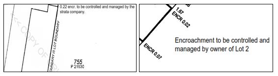
Where part of a building is within 2 metres of a parcel boundary, offsets must be shown on the location plan. Any part of the building or attachment to the building that encroaches beyond the parcel onto an adjacent parcel, road or ROW must be clearly shown on the location plan by dashed linework.Section 34(d)(ii) of the STA provides that where part of a strata development, such as a roof, wall or building foundation is built upon adjacent land that is not a public road, street or way, an appropriate easement for that part of the roof, wall or foundation which encroaches onto that other land must be granted and lodged with the Registrar before registration of the Strata Plan can proceed. Section 32(1)(j) states that the plan must identify the nature and extent of the encroaching structure and, if it is to be subject to an easement, specify that easement.One of the appropriate easements is an easement of support for the part of the building erected on the strata scheme (benefitted land) for that portion of roof, wall or foundation of the said building erected upon the adjacent parcel (burdened land). This type of easement recognises that that portion of the roof, wall or foundation belongs to the owner of the burdened land. Persons considering using this type of easement should obtain legal advice (see Plan Example 11).It may be more appropriate to effect a subdivision which adds that part of the adjacent land subject to the “encroachment” to the parcel. Refer to section 166 of the P & D Act. This will require the cooperation and consent of the owner of the adjacent land.Easements in respect of “encroachments” must be lodged for registration before the application for registration of the strata titles scheme. In the case of an easement for support from part of a wall or building on the burdened land, the easement document must be lodged with, but preceding the application for registration of the strata titles scheme.Encroachments can be walls, gutters and eaves, awnings, plinths, corbels or other similar building attachments. Building connections and wall encroachments should be made to reference mark accuracy. The extent of the encroachment and type must be dimensioned and noted. Also, a statement specifying that the encroachment is to be controlled and managed as if it were common property or as if it were part of a lot is required to be endorsed next to the encroachment graphic. Alternatively, if there are several encroachments shown on the plan, a general statement on the Location Plan will be acceptable.
2.4. Floor Plan
The floor plan must be drawn at a scale and orientation in accordance with the TLA requirements. The orientation must be consistent with the location plan. The floor plan may be on a separate sheet or, space permitting, included with the location plan.A “floor plan’ is in reality a plan of the level or stratum and does not have to be confined to the floor of a building. It is in fact a plan view of the base of a cubic space forming a lot or parts of a lot.The perimeter of a building forming the external surface of cubic space should be shown by a thick line to indicate the walls of the building. Lines that are buildings or monuments should be thicker lines or can be shown by parallel lines (tram lines). Usually thinner lines that are dimensioned or partly dimensioned delineate boundaries of part lots that are external to a building.Surveyors should show the outline of the building to which the local government certificate is to apply. It may be useful in complex situations to assist lot identification by creating separate part lots for carports, garages, store sheds and verandahs. There is no requirement to follow this practice or to specify the use of each of these part lots on the plan. However, it may be useful, particularly where the walls are to be common property.In cases where there is more than one floor level, each level must be able to be superimposed on the other levels. Separate sheets for each level can achieve this. Two floor plan levels may be shown on the same sheet provided appropriate registration marks (e.g. a common point of overlay or part of the parcel boundary) are placed on each level to enable superimposition. If using the latter method, the scale must be common to all sheets of the plan and the detail clearly shown.If a lot consists of more than one part, then the lot number shown on each of the parts must be prefixed by “Pt” (see regulation 16(4) ST(G)R) to indicate that there are other parts forming the lot. The area of each part lot should be shown close to the “Pt” lot number. If possible, the lot number and area should be within that specific part of the lot. If, due to lack of space this is not possible the “Pt” lot number and area can be shown externally and then ticked in to indicate the designation of that part. Areas of all the parts should be added to give a total area, which should be shown in brackets within the main “Pt” lot, which is normally, the actual part lot forming or comprised in the building.For strata plans that have parts of lots on more than one floor level (eg Basement, Ground Floor & First Floor), a table setting out the lot number, total area, floor or level and the sheet number is required to be shown on the Location Plan (see sample table below:
|
Lot |
Total Area |
Floor |
Sheet |
|
1 |
57 |
B, G, 1 |
2, 3, 4 |
|
2 |
77 |
B, G, 1 |
2, 3, 4 |
|
3 |
79 |
B, G, 2 |
2, 3, 5 |
|
4 |
55 |
B, 2, 3 |
2, 5, 6 |
|
5 |
55 |
B, 2, 3 |
2, 5, 6 |
A CSV file containing this information is required as part of the lodgement of the plan.The CSV file will outline the total area, floors and sheets for each lot as shown in the below table and example.
|
CSV Attributes |
|
|
Attribute |
Definition |
|
lotident |
Lot number |
|
areatotal |
Total area of Lot |
|
floors |
Text string of floors for Lot |
|
sheets |
Text string of sheets for Lot |
Example CSVlotident,areatotal,floors,sheets1,57,"B,G,1","2,3,4"2,77,"B,G,1","2,3,4"3,79,"B,G,2","2,3,5"4,55,"B,2,3","2,5,6"5,55,"B,2,3","2,5,6"All parts of a lot should be contained within the one sheet, if possible. Alternatively, join marks and notations should be used so, if needed, the floor plan sheets may be compiled to create the scale version of the complete lot or “Pt” lots. If patios, carports, pergolas, enclosed rooms, storage rooms or similar structures are to be included as building part lots under Schedule 1 clause 3AB of the STA, they must be shown on the floor plan (see Schedule 1 clause 4 of the ST(G)R).Floor plans are designed to show the basis of calculation of the cubic space of the lots. Common property generally should not be shown on the floor plan. The ST(G)R do not permit extra information in the form of broken lines or notations that indicate letterboxes, driveways, carports, garden areas or similar information that is not used for defining lot boundaries.Voids are an integral part of a floor plan and usually denote the air space where stairways form part of a first or second floor in buildings such as villas and town houses. They may be labelled “Void” or “Stairs” and defined by either pecked lines or solid single lines. While “Voids” form part of the Lot, their area is excluded from the area calculated for that level. Where there is some doubt as to the ownership of abutting voids, surveyors should label each void with the corresponding Pt Lot identifier.In some instances it may be beneficial to label common property as “Void – Common Property” to ensure there is no conflict as to ownership of such areas (see Plan Example 24).
2.5. Surveyors Certificate
All new Strata Plans lodged for registration at Landgate must have a certificate signed by a licensed surveyor under regulation 54 of the Licensed Surveyors (General Surveying Practice) Regulations 1961. This Certificate ensures the Surveyor is fully accountable for the correctness of the strata plan (see Plan Example 25).Correct certification by surveyors plays a key role in the strata titling system as it signifies that certain parameters are met before registration. It is therefore important that surveyors are aware that they are certifying to everything shown on the plan, including specifying the easement required for any encroachment beyond the parcel which is not over a public road, street or way.If there is an encroachment (other than a minor encroachment or circumstance as set out in Regs. 45A and 45B of the Building Regulations 2012) onto a public road, street or way, DPLH must be contacted and consent obtained from the Minister for Lands and whoever has control and management of the road. Where consent for the encroachment has been refused, an Order of the Magistrates Court may be obtained. Minor encroachments do not require consent. If the encroachment is onto private road or R.O.W. steps should be taken to close and amalgamate that portion of land with the subject parcel.
2.6. Measurement Contents
Information shown on a strata plan must be sufficient to establish the lot boundaries of every lot. Some surveyors follow the practice of showing a fully dimensioned plan with measurements to two (2) or three (3) decimal places and angles to 1”. Whilst this may appear to be of a high standard, the reality of measuring walls, fences and other monuments to this accuracy is not necessary for strata plans. The requirements of the STA have been designed to provide sufficient dimensioning or notation to define the lot extremities.On a strata plan there must be sufficient information shown to establish lot boundaries. There is no requirement to show full dimensioning. However, if the plan is fully dimensioned, distances and areas must agree with the parent “Freehold” information. Where certain Special Survey Areas (SSA) and Redevelopment Authority Deposited Plans show dimensions to three (3) decimal places, surveyors should prepare strata plans to the same accuracy.
2.7. Describing Cubic Space
The use of section 3(2)(b) of the STA when describing cubic space must refer to a wall, floor or ceiling or structural cubic space within the building to which the plan relates and cannot refer to “external surface of building” or “roof”.Where the underside of a roof forms part of the ceiling and it is intended that the roof form part of the cubic space, the upper boundary of a lot could be described by specifying a distance above the ceiling, so that the roof fits within that measurement. However this definition will not enable inclusion of any part of the roof that extends beyond the line of the inner surface of the walls (see STP-02 and Plan Example 26).
2.8. Large Plans (Rural or Staged)
Occasionally, problems are encountered when the detail and coverage of the strata plan will not fit the A3 size format. Each case should be considered on its merits. The plan must be clear and easy to understand. If possible, the whole of a part lot should be confined to one sheet.The pictorial representation should be carefully planned. It may overlap numerous sheets, so the plan sheets should be laid out and then an appropriate scale used to meet the criteria listed above. Join marks may be used on lot or parcel boundaries so that it is possible to piece together the complete picture.
3. Drafting of Survey-Strata Plans
Most drafting guidelines for survey-strata plans are common to all plans under the STA. This chapter records only matters which do not apply to all other types of plan.
3.1. Easements
The easements that can be created on a survey-strata plan by short form under section 33 of the STA and are set out in Part 5 of the ST(G)R and include easements for vehicle access, light and air, party wall rights, intrusion by a structure, pedestrian access, easements in gross and utility services. Easements for these purposes can also be created using the provisions of the TLA as set out in Part IVA of that Act.Multiple easements over the same portion of a Lot must be recorded individually in the “Interests and Notifications” Schedule/”New Interests” Schedule. This will result in strata titles issuing with multiple endorsements and enable each easement to be dealt with individually should the need arise to have an easement modified or extinguished/discharged (see Plan Example 38).
3.2. Surveyors Certificate
A Certificate signed by the surveyor under regulation 54 of the Licensed Surveyors (General Surveying Practice) Regulations 1961 must be shown on the survey-strata plan. This ensures the Surveyor is fully accountable for the correctness of the survey-strata plan in the same manner as is required for a standard deposited plan.
3.3. Certificate of Verifying Surveyor
The Directions to Surveyors under regulation 5 of the Licensed Surveyors (Transfer of Land Act 1893) Regulations 1961 define a Survey Document as “any plan, (including its component digital record), including but not limited to compiled plans and survey-strata plans”. The directions require that any Survey Document that is certified by a licensed surveyor, who is not eligible to verify survey documents at the time the document is lodged at Landgate, must be verified and countersigned by a licensed surveyor who is so eligible, in accordance with the directions. The certificate in the following table must be added to the plan and signed by the verifying surveyor.I ________________________ being eligible, in accordance with the Land Surveyors’ Licensing Board’s requirements, to verify survey documents have checked this plan (and its digital record) by ________________________ (Licensed Surveyor) and I verify that the plan is error free and consistent with the field record and digital record and complies with the Landgate Policy and Procedure Guides, except where good reason has been shown to the contrary, and with all regulations applicable to it.Date:__________________ Signed: _______________________________ (Licensed Surveyor)
3.4. Pegs
New boundary pegs must be recorded on the plan, as should descriptions of any variations from standard (regulation) marking. Where the position of original or existing pegs has been adopted, there is no need to show those pegs on the plan. The position of each peg that is not placed exactly at a corner of a lot should also be recorded (see Plan Example 3, Plan Example 8, Plan Example 9 and Plan Example 10).
3.5. Other Information
Because the survey-strata plan must be sighted by the buyer of a lot it is desirable to make the plan as useful as possible for this purpose, including minimising the amount of technical information on the plan.For this reason (unlike TLA plans) the following information should NOT be shown on survey-strata plans:
- orig and per orig annotations
and
- OM, MF, MFR, MGR etc. annotations.
For the same reason, it is essential to show any pegs that are necessarily out of position, any non-standard marks and any building connections on the plan (see Plan Example 8, Plan Example 9 and Plan Example 22). Enlargements should be used where the situation cannot clearly be depicted on the main body of the graphics.
3.5.1. Encroachments, Building Connections
If part of a building, wall or other significant improvement is built such that it crosses over the boundary between the subject land and an abutting lot, the encroachment must be recorded on the plan. Connections to buildings, walls and other types of significant improvements that are close to, but do not cross over the boundary of the subject land may be recorded on the plan at the surveyor’s discretion (see Plan Example 10 and Plan Example 23).
3.6. Easements and Restrictive Covenants
Under the STA and the TLA, it is possible to create easements and restrictive covenants over land in the same ownership. This has numerous advantages where a developer may put in place easements and restrictive covenants for various purposes over the subject land at the time of registration of the plan.The STA and the TLA contain standard wordings that can eliminate the need for any written documentation. However, it is also possible to vary the terms of these easements or restrictive covenants or provide for specific needs by an instrument that is in the form of a deed.Scheme plans and amendments of scheme plans lodged for registration can create:
- short form easements and restrictive covenants under Part IVA of the TLA
- short form easements under section 167 of the P & D Act
- short form easements and restrictive covenants under section 33 of the STA
- restrictive covenants (Road Access Conditions) under section 150 of the P&D Act;
and include:
- easements and covenants created by deed or transfer1.
1[Guide updated on 25/05/202 to insert the word 'created']It is not possible to automatically create section 136C TLA easements such as ‘Right of Carriageway’ on amendments of scheme plans.Easements that are created under the TLA or the STA need to be shown in a Interests and Notifications schedule/New Interests schedule on the plan and be shown by broken lines, dimensions and angles on the plan. Original easements and covenants being brought forward that have a spatial nature also need to be shown (see Plan Example 10).
3.6.1. TLA Easements
Section 65, Part IVA section 136C and Ninth and Tenth Schedules of the TLA refer to the following types of “standard” easements:
- Right of carriageway
- Right of footway
- Water supply purposes
- Drainage purposes
- Gas supply purposes
- Transmission of electricity by overhead cables
- Transmission of electricity by underground cables
- Transmission of television signals
- Party wall rights
- Eaves and gutters
- Sewerage purposes
- Parking of motor vehicles.
3.6.2. Easements That do not meet the terms in the Tenth Schedule of the TLA
Where an easement that is required does not meet these terms, an “instrument” varying the terms of the easement can be lodged with the Strata/Survey-Strata Plan. The instrument must be in the form of a deed, prepared on a TLA form B2 and must be capable of registration. For full registration details, see Land Titles Registration Policy and Procedure Guide EAS-01, Section 7
3.6.3. P&D Act Easements
Section 167 of the P&D Act provides for the automatic creation of service authority easements in gross on registration of scheme plans and amendment of scheme plans. The statutory wording of these various easements is set out in regulation 33 of the Planning and Development Regulations 2009 (see Plan Example 52).Where there is a requirement to create section 167 P&D Act easements on strata plans that are exempt from the requirement of approval by the WAPC, then it is important for surveyors to note that the P&D Act makes no provision for those plans to be endorsed by the WAPC. Surveyors are required to provide a CSD file when creating section 167 P & D Act easements on a strata plan.Where a building encroaches upon an existing section 167 P & D Act easement, surveyors should identify at the earliest possible moment and consideration should be given to have the easement extinguished, partially extinguished or varied in height so that no building part lot (including balconies) is encumbered by the easement. Failure to identify and negotiate the modification of that easement may cause unnecessary financial cost and delays for the developer. In the case where an easement encumbers the basement carbay part lot of a multi-tier scheme, the easement may be limited in height (metres AHD) to the undersurface of the basement ceiling. This will enable the service authorities to maintain and access the easement. From time to time surveyors may encounter lightweight structures e.g. carports, pergolas etc. (non-building part lots) that hang into or over section 167 P&D Act easements.For any encroaching structure, contact should be made with the service authority benefiting from the easement. A partial extinguishment may be required or a letter from the service authority consenting to the structure being within the easement. This letter should be lodged with the strata plan so as to alert Landgate’s strata plan examiners that the matter has been attended to.
3.6.4. STA Easements
Easements created pursuant to section 33 of the STA are created automatically on registration of the scheme plan or an amendment of a scheme plan. Although only the abbreviated name of the easement needs to be shown on the plan, the terms of the easements are prescribed in the ST(G)R. These types of easements are confined to the subject land, i.e. it is not possible to benefit land outside of the scheme.The following short form easements may be created under section 33 of the STA:
- Vehicle Access Easement under regulation 31 of the ST(G)R (see Plan Example 3).
- Light and Air Easement under regulation 32 of the ST(G)R.
- Party Wall Easement under regulation 33 of the ST(G)R (see Plan Example 13).
- Intrusion Easement under regulation 34 of the ST(G)R (see Plan Example 7, Plan Example 10 & Plan Example 45).
- Pedestrian Access Easement under regulation 35 of the ST(G)R.
- Easement in Gross under regulation 36 of the ST(G)R
- Easement for Utility Services under regulation 37 of the ST(G)R
These types of easements can also be created on plans of conversion to survey-strata. For merger sketch plans, only Vehicle Access Easements can be created - see Schedule 2A, clause 21W of the STA.If special conditions are required, the standard form of the easements may be varied by lodging a memorial or instrument that sets out the specific conditions before the plan is registered. This memorial or instrument, along with the scheme plan or amendment of the scheme plan, are deemed by the ST(G)R to be “short form documents”.Easements created under section 33 of the STA may be varied or discharged under section 33(6)(a) STA (see Requirements for Registration of Amendment of a Scheme Plan).When dealing with Vehicle Access (Reg 31) and Pedestrian Accessway (Reg 35) easements, the ST(G)R provided for these easements to be ‘exclusive’ or ‘non-exclusive’. If the easement is exclusive, the grantee must keep the easement area in good order (including by doing any repairs, replacements, maintenance, cleaning or other upkeep). This needs to be stated in the ‘Comments’ column of the Interests and Notifications Schedule (see ![]() in the table example below).If the easement is to be non-exclusive:
in the table example below).If the easement is to be non-exclusive:
- the grantor will need to keep the easement area in good order (including by doing any repairs, replacements, maintenance, cleaning or other upkeep); and
- the grantee will be required to reimburse the prescribed proportion of the costs incurred by the grantor in keeping the easement area in good order.
Unless specified otherwise by either the plan or an instrument, the prescribed proportion will be:
- the proportion that the unit entitlement of the grantee’s lot bears to the total unit entitlements of the grantor’s and the grantee’s lots, or
- if common property is burdened by the easement, the proportion that the unit entitlement of the grantee’s lot bears to the sum of the unit entitlements of all lots in the strata titles scheme; or
- if common property is benefited by the easement, the proportion that the unit entitlement of the grantor’s lot bears to the sum of the unit entitlements of all lots in the strata titles scheme.
If the apportionment of upkeep is not to be the prescribed proportion, the desired proportion is to be specified in a memorial or instrument lodged at Landgate.Easements in Gross (Regulation 36 ST(G)R)The short form documents may describe the terms of the easement by reference to a:
- planning condition,
- statutory provision or
- contract.
If the terms of the easement are to be contained in a planning condition or contract, to enable visibility and searchability of the terms, the ST(G)R enables a copy of the contract, statutory provision or planning condition to be contained within a memorial or instrument lodged with the application to register the scheme or amendment of scheme.If the easement expires at the end of a specified period, it will be taken to mean that the grantor and grantee consent to the Registrar of Titles discharging the easement in gross at any time after the end of the specified period, without any application or notice being lodged at Landgate (see ![]() in the table example below).Easements for Utility ServiceUtility Service
in the table example below).Easements for Utility ServiceUtility Service
- water supply
- drainage
- gas supply
- transmission of electricity by overhead cable
- transmission of electricity by underground cable
- transmission of communication signals by overhead cable
- transmission of communication signals by underground cable
- sewerage
The rights conferred by the easement are set out in regulation 37 of the ST(G)R and are very similar to the rights set out in section 136C and Tenth Schedule of the TLA. However, unlike section 136C, the STA doesn’t require the written consent of any person who has a registered interest or is a caveator in respect of the land being burdened by the easement. The consents required are the designated interest holders, which are defined in the STA as:
- a registered mortgage; or
- a registered lease; or
- a caveat recorded under the Transfer of Land Act 1893; or
- the interest of a judgment creditor named in a property seizure and sale order registered under the Transfer of Land Act 1893 section 133; or
- the interest of a person named in a memorial registered under the Transfer of Land Act 1893 as having a statutory right requiring the consent of the person to any dealing with the land; or
- a plantation interest registered under the Transfer of Land Act 1893; or
- a carbon covenant registered under the Transfer of Land Act 1893;
This could be considered as a viable option when creating utility service easements on strata title schemes where an estate covenant exists on the parent title and all the lots created on the Deposited Plan of the parent lot are benefited and burdened by this covenant.Example Schedule of Interests and NotificationsINTERESTS AND NOTIFICATIONS
|
SUBJECT |
PURPOSE |
STATUTORY REFERENCE |
ORIGIN |
LAND BURDENED |
BENEFIT TO |
COMMENTS |
|
|
EASEMENT (VEHICLE ACCESS) |
SECTION 33 STA REG 31 |
THIS PLAN |
LOT 1 |
LOT 2 |
|
|
|
EASEMENT (LIGHT AND AIR) |
SECTION 33 STA REG 32 |
THIS PLAN |
LOT 1 |
LOT 2 |
|
|
|
EASEMENT (PARTY WALL) |
SECTION 33 STA REG 33 |
THIS PLAN |
LOT 2 |
LOT 1 |
|
|
|
EASEMENT (INTRUSION) |
SECTION 33 STA REG 34 |
THIS PLAN |
CP3 |
LOT 1 |
|
|
|
EASEMENT (PEDESTRIAN ACCESS) |
SECTION 33 REG 35 |
THIS PLAN |
LOT 2 |
LOT 1 |
THIS EASEMENT IS EXCLUSIVE |
|
|
EASEMENT (DRAINAGE) |
SECTION 33 REG 36 |
THIS PLAN |
LOT 2 |
CITY OF STIRLING |
|
|
|
EASEMENT |
SECTION 33 REG 36 |
THIS PLAN & DOC……….. |
LOT 2 |
ATCO |
EXPIRES ON 31.12.2050 |
|
|
EASEMENT (WATER SUPPLY) EASEMENT (DRAINAGE) EASEMENT (GAS SUPPLY) EASEMENT (TRANSMISSION AND DISTRIBUTION OF ELECTRICITY BY OVERHEAD CABLE AND CONDUCTORS) EASEMENT (TRANSMISSION AND DISTRIBUTION OF ELECTRICITY BY UNDERGROUND CABLE AND CONDUCTORS) EASEMENT (TRANSMISSION OF COMMUNICATION SIGNALS BY OVERHEAD CABLE) EASEMENT (TRANSMISSION OF COMMUNICATION SIGNALS BY UNDERGROUND CABLE) EASEMENT (SEWERAGE) |
SECTION 33 REG 37 |
THIS PLAN |
LOT 2 |
CITY OF WANNEROO |
3.7. Restrictive Covenants
These are a restriction on the land and can be utilised for such things as building restrictions, height restrictions and limitations on building materials, aesthetics and similar controls on appearance, access and use of the land. Restrictive covenants can be created on the scheme plan (Sec 136D TLA, Sec 33 STA and Sec 150 P&D Act) or by deed Sec 129A and Sec 129BA TLA). These types of covenants can be between lots within a strata titles scheme or benefits may be given to land outside the scheme or public authority/local government.An important feature of Sec 136D TLA and Sec 33 STA covenants is that they have effect even while the land burdened and benefited are in the same ownership.Sec 33 STA provides that restrictive covenants can be created benefitting local governments and public authorities only. Regs 43 to 47 of the ST(G)R sets out the purpose, rights and liabilities of the restrictive covenants:-
- Right of way restrictive covenant - to prevent development in a right of way setback
- Land use restrictive covenant - to restrict the use of land
- Conservation restrictive covenant - to protect areas identified for conservation
- Building envelope restrictive covenant - to control the siting of development
- Fire restrictive covenant - to restrict development in fire prone areas
The rights and liabilities of these restrictive covenants may be varied by a memorial or other instrument lodged at Landgate. For Land Use and Conservation Covenants, a memorial or other interest will be required to provide more specifics in regard to the restrictions on Land Use and Conservation.INTERESTS AND NOTIFICATIONS
|
SUBJECT |
PURPOSE |
STATUTORY REFERENCE |
ORIGIN |
LAND BURDENED |
BENEFIT TO |
COMMENTS |
|
|
RESTRICTIVE COVENANT (RIGHT OF WAY) |
SECTION 33 STA REG 43 |
THIS PLAN |
LOT 1 |
LOCAL GOVERNMENT OR PUBLIC AUTHORITY |
|
|
|
RESTRICTIVE COVENANT (LAND USE) |
SECTION 33 STA REG 44 |
THIS PLAN & DOC………. |
LOT 1 |
LOCAL GOVERNMENT OR PUBLIC AUTHORITY |
|
|
|
RESTRICTIVE COVENANT (CONSERVATION) |
SECTION 33 STA REG 45 |
THIS PLAN & DOC………. |
LOT 2 |
LOCAL GOVERNMENT OR PUBLIC AUTHORITY |
|
|
|
RESTRICTIVE COVENANT (BUILDING ENVELOPE) |
SECTION 33 STA REG 46 |
THIS PLAN |
CP3 |
LOCAL GOVERNMENT |
|
|
|
RESTRICTIVE COVENANT (FIRE) |
SECTION 33 STA REG 47 |
THIS PLAN |
LOT 2 |
LOCAL GOVERNMENT |
Alternatively, restrictive covenants may be created under section 129A of the TLA using an instrument. It is also possible to benefit land outside of the scheme by utilising this method. This means a strata/survey-strata lot may be encumbered by a covenant, but land outside the scheme may benefit from that covenant (see Plan Example 49).A local government may impose a section 129BA of the TLA restriction as a condition of subdivision over a portion of a proposed lot abutting a Right of Way, Way or Lane in order to prevent new developments taking place over a prescribed portion of the subject land. Such restrictions are usually used to accommodate future widening of the Right of Way. Surveyors must show the extent of the restrictive covenant spatially on the plan and endorse the covenant in the Interests and Notifications Schedule (see Plan Example 10, Plan Example 14 & Plan Example 45).Section 150 of the P&D Act allows Road Access Conditions, imposed by WAPC, to be endorsed on scheme plans. Conditions imposed as a restriction or prohibition on land abutting a road is to be shown in the Interests & Notifications schedule as a “COVENANT” (see Plan Example 52).Regulation 30 of the Planning & Development Regulations 2009 is used to impose Road Access Conditions. A Road Access Condition must be identified and labelled with such a notation as A – B. Details of the restriction or prohibition and to whom or what it applies and when and in what circumstances, is to be noted in the COMMENTS field of the Interests & Notifications schedule on the plan.The covenantee can only be one of the following:
- Western Australian Planning Commission
- Commissioner of Main Roads
- Minister administering Public Works
- Local Government
Landgate would expect however, that should a planning condition relate to “Control of Access”, then the automatic tools under regulation 30 would be used rather than the continued use of section 129BA of the TLA.Surveyors are advised that:
- The WAPC may impose a condition under section 150 of the P&D Act that access to and from a portion of land shown on a plan of survey relating to the subdivision to a road abutting the portion of land is to be restricted. Section 150 of the P&D Act does not apply to "future" road/road widening or a pedestrian access way. A restriction on access in these cases can be effected by a restrictive covenant under section 129BA of the TLA.
- The notation in the comments field of the Interests and Notifications schedule must specify to the following "to and from". E.g. NO VEHICULAR ACCESS TO AND FROM GREAT EASTERN HIGHWAY.
- All new lots created from the parent lot on a plan of subdivision are burdened by the restrictive use that was created by the covenant on the parent lot.
Note: Section 150 of the P&D Act does not replace Restrictive Covenants created under section 129BA of the TLA but should be depicted in the same manner.
A Road Access Condition covenant can be modified or discharged under regulation 32 of the Planning & Development Regulations 2009 by application to WAPC. When consent has been granted, an application is made to the Registrar of Titles to modify or discharge the covenant accordingly and make any entries or endorsements that may be necessary to evidence the modification or discharge.Any modification of a spatial nature would require an Interest Only Deposited Plan to accompany the Application to modify the covenant.An appeal to SAT is available to an applicant if WAPC refuses a request to modify or discharge a Road Access Condition covenant.
4. Requirements for Registration of a Scheme Plan
Registration of a Scheme Plan will not be possible without being accompanied by the following certification from the:
- Permit Authority
- Western Australian Planning Commission (WAPC)
4.1. Permit Authority Certification
All Strata Plans must have either an Occupancy Permit (OP) or a Building Approval Certificate (BAC), granted by the Permit Authority (local government) under the Building Act 2011(BA). They must be lodged with the strata plan to enable registration of the strata plan and the issue of certificates of title for the lots the subject of the strata plan (see Plan Example 1 and Plan Example 24).Surveyors may lodge a strata plan at Landgate before the OP or BAC being signed and issued by the local government. This enables the strata plan to be examined but not put "In Order for Dealings" while the permit or certificate is waiting to be issued by the local government. Surveyors using this method may lodge the OP or BAC subsequently. However, if the OP or BAC is available before the strata plan being lodged, it must accompany the plan.Landgate receives all OP’s and BAC’s electronically as a scanned PDF document with the plan before the application to register the strata scheme is lodged. It is the owner's responsibility to provide their licensed surveyor with a legible OP/BAC.The following information, key to Landgate’s requirements, will need to be depicted on all BA forms:
- correct strata plan number and lot on survey details; and
- name and endorsed signature of the Local Government Issuing Officer along with the date of signing.
Failure to provide this information in a clear and legible format will result in the form being rejected and requiring replacement.Due to the need for consistency of practice for industry groups, local governments, Landgate and the Building Commission, a list of standard requirements are listed at Sec 5.1 below.
4.2. Requirements for Building Act Forms: see 5.1
Where the Permit Authority does not grant an Occupancy Permit or a Building Approval Certificate, an applicant may apply to the State Administrative Tribunal for a review of the decision under the BA.
4.3. WAPC Certification
Strata plans that do not fit the exemption criteria, as specified in regulation 19 of the ST(G)R, must be accompanied by a certificate endorsed correctly by local government (delegate under section 16(3)(e) of the P&D Act 2005) or the WAPC.For instances where the WAPC approves the strata plan, the WAPC certificate must be incorporated into the appropriate plan sheet (see Plan Example 11).For instances where the WAPC delegates its powers for approval to local government, Landgate will accept a “scanned” signed copy of the certificate as a PDF file.Surveyors have the choice of the following options:
- lodge the WAPC certificate (where delegated) at the local government, wait for the signed WAPC certificate (along with the signed OP or BAC) to return from the local government and lodge at Landgate as a scanned PDF
or
- lodge the strata plan at Landgate and at the same time send the WAPC certificate (where delegated and with the Application for OP or BAC) to the local government. In this option, Landgate will conduct an examination of the strata plan and mark it with a status of “examined” subject to lodgement of WAPC certificate and OP /BAC.
All survey-strata plans must go through the full planning referral process as required by the WAPC. This means referral to appropriate government agencies for comment. For a survey-strata plan the certification is referenced to section 17(3) of the STA. The WAPC reference number must be endorsed onto the plan.
4.4. Cancellation of a Strata/Survey-Strata Plan2
Refer to SPP-10 Plan Practices section 16 Cancellation of Plans for information about cancelling plans2Section updated 01/10/2021
4.5. Requirements for Registration of an Amendment of a Scheme Plan (section 35 STA)3
4.5.1. Amendment of scheme plan effecting subdivision
There are 4 types of amendment of a strata titles scheme that give effect to a subdivision:
- Type 1 subdivision covers:
- addition of land from outside the parcel to the common property and
- conversion of lots within the scheme into common property.
- Type 2 subdivision covers the removal of common property from a scheme.
- Type 3 subdivision covers consolidation of lots within a scheme.
- Type 4 subdivision covers subdivision of lots and/or common property within a scheme.
For full details on the registration of all the above the Type 1 subdivision scenarios, see Land Titles Registration Policy and Procedure Guide STR-04.
3Section updated 25/03/2022
4.6. Plans required for type 1 (a) subdivisions3
In the case of land adjoining or contiguous to the scheme, a deposited plan must be prepared incorporating the land to be acquired with the existing scheme, together with a depiction of any residue land as a separate lot. This deposited plan must be processed through the normal planning approval process until the plan becomes “in order for dealings”.
Surveyors are also required to lodge a type 1 subdivision plan amendment to reflect the additional land in the scheme (see Plan Example 63). This plan will show the new parent lot details under the Revised Parent Tenure heading. The following notation is an example of the Plan Purpose:
ADDITION OF LAND OUTSIDE THE PARCEL TO CP -TYPE 1(a) SUBDIVISION
Note: see SPP-10 Section 2 Plan Heading for addition information.1
1Added 25/05/2021
In the case of strata plans, this will require lodgement of a Location Plan only. This plan should show all the latest abuttal and offsets (if required) information (see Plan Example 57). The sheet numbering should be the same as the Location Plan it is replacing. In the case where the Location and Ground Floor Plan of the original strata plan are on the same sheet e.g. ‘Sheet 1 of 1 Sheet’, the sheet showing the new Location Plan should be numbered ‘Sheet 1A of 1 Sheet’. S
In the case of survey-strata plans, a new plan depicting the new common property details will be required (see Plan Example 58). The land included is allocated the letters “CP” followed by a number.
No field record will be required to be lodged with the plan as it will most likely be a compiled plan. The field record numbers shown on this plan can be the field record for the parent Deposited Plan and/or other field books used in its compilation.
For types 1(a) subdivisions involving the construction or modification of a building, a BA form will be required to be lodged with the plan. If no building is involved, no BA form will be required.
A merger, survey-strata conversion (for strata plans only) or type 4 subdivision is needed to enable this common property to become part of the lots, if that is desired. Alternatively, it may remain as common property.
3Section updated 25/03/2022
4.7. Type 1(b) Subdivision - Conversion of Lot/s Within a Scheme to Common Property3
Note: see SPP-10 Section 2 Plan Heading for addition information.1
1Added 25/05/2021
The STA permits a lot within a scheme to be transferred to the strata company, converting the lot to common property. It is only possible to convert whole lots into common property. The strata company must pass a resolution without dissent to convert a lot or lots into common property provided the scheme consists of three or more lots. A Type 1(b) subdivision of the strata titles scheme requires approval from the WAPC.
Surveyors are required to lodge a type 1(b) subdivision plan amendment, which will be accompanied by a schedule of unit entitlements showing the unit entitlements of the remaining lots and the adjusted sum of all unit entitlements. For strata plans a new location (in most cases) and floor plan is required. For survey-strata plans, a plan showing details of the additional common property is required.
The following notation is an example of the Plan Purpose:
TRANSFER OF LOTS TO CP - TYPE 1(b)
On registration the interests and operation of the encumbrances of the remaining lot proprietors are extended to include the additional common property.
In the case of a survey-strata plan the converted lot will be allocated the letters “CP” followed by a new number.
For full details on the registration of Type 1(b) subdivisions, see Land Titles Registration Policy and Procedure Guide STR-04.
Note: Type 1 subdivision plans will require approval from the WAPC as per section 35(1)(f) of the STA.
3Section updated 25/03/2022
4.8. Type 2 Subdivision - Transfer of Common Property3
Note: see SPP-10 Section 2 Plan Heading for addition information.1
1Added 25/05/2021
The STA permits land that is common property to be transferred by the strata company, removing it from the scheme. A deposited plan is necessary to define the land to be transferred.
On approval of the deposited plan, surveyors are also required to lodge a type 2 subdivision plan showing the new boundaries of the strata titles scheme after the disposal of common property, the following notation should be shown:
REMOVAL OF CP FROM THE PARCEL - TYPE 2
This plan will show the new parent lot details under the Revised Parent Tenure heading. In the case of strata plans, this will require a replacement Location Plan only. This plan should show all the latest abuttal and offset (if required) information (see Plan Example 59). The sheet numbering should be the same as the Location Plan it is replacing.
In the case where the Location and Ground Floor Plan of the original Strata Plan are on the same sheet e.g. ‘Sheet 1 of 1 Sheet’, the replacement sheet showing the new Location Plan should be numbered ‘Sheet 1A of 1 Sheet’.
In the case of survey-strata plans, a new plan showing the amended details of the existing common property will be required. No field record will be required to be lodged with the plan as it will most likely be a compiled plan. The field record numbers shown on this plan can be the field record for the parent deposited plan and/or other field records used in its compilation (see Plan Example 60).
Note: The type 2 subdivision plan will require approval from the WAPC as per section 35(1)(f) of the STA.
3Section updated 25/03/2022
5. Summary3
To sum up, if a “multiple owner” freehold subdivision involves the transfer of a lot, or part of a lot, in a strata titles scheme, the affected lot (type 1(b) subdivision), or portion (type 4 subdivision), must first be converted into common property before being transferred out of the strata titles scheme.
Similarly, where land is being transferred into a strata titles scheme by a freehold subdivision the land can only be included as common property by a type 1(a) subdivision.
The “balance lot” requirements for a freehold subdivision involving a strata titles scheme are:
- If only common property is involved in the land being transferred (in or out) then the following plans will need to be lodged:
- a new deposited plan showing the new freehold lots as in a normal subdivision and
- a type 1(a) or 2 subdivision plan reflecting the change to the strata titles scheme
- Where it is intended that a new subdivision will involve the transfer of part or all of an individual lot or lots within a strata titles scheme then the scheme must either:
- be terminated, if transferring a whole lot in a 2 lot scheme or
- a type 1(b) subdivision (whole lot), or 4 subdivision plan amendment must be lodged converting the affected land into common property. A deposited plan can then be lodged for the subdivision, as outlined previously.
- If it is intended that land being transferred into a strata titles scheme is to be included in a particular lot within the scheme, the land must:
- first be included in the scheme as common property by a freehold deposited plan of subdivison, followed by
- a type 1(a) subdivision plan amendment, then
- a type 4 subdivision plan amendment, merger sketch plan or plan of conversion to survey-strata, depending on the nature of the current scheme and when it was registered.
5.1. Permit authority certificate
Requirements for Building Act forms1
- All buildings shown on a Strata Plan are to be covered by an Occupancy Permit (OP) or Building Approval Certificate (BAC).
- Landgate will accept both an OP and a BAC for the same Strata Plan where different classes of buildings exist within the same scheme.
- Landgate will not accept more than one OP or more than one BAC for the same SP.
- Strata lot numbers applying to either an OP or a BAC are to be clearly identified.
- Where the information on the OP or BAC is unclear, the lodging party will be notified.
1Dot point "Landgate will not accept a temporary OP for incomplete building." removed 04/05/2021
The STA provides that, where there is an amendment to the scheme plan, it is to be accompanied by an occupancy permit or building approval certificate for each scheme building constructed or modified in the course of a subdivision to be given effect by registration of the scheme or amendment of the scheme. This means that, for any amendment of a strata plan (including subdivision types 1 and 2) which involves the construction or modification of a building, a BA form will be required to be lodged with the plan. If no building is involved, no BA form will be required.
5.2. Type 3 Subdivision - Consolidation of Lots
Type 3 subdivision is the consolidation of 2 or more lots in a strata titles scheme into one lot in the scheme (a type 3 subdivision cannot include any of the common property in the scheme). For strata plans, a floor plan is required showing the consolidated lot and a location plan is necessary if there are vacant lots or part lots external to a building (see Plan Example 36 and Plan Example 37). Type 3 subdivision plan amendmentss for survey-strata schemes also depict the lots that have been consolidated (see Plan Example 39).
For type 3 subdivisions of strata schemes, the plan will need to be accompanied by an occupancy permit or building approval certificate only if there are buildings modified as a result of the consolidation. Unless exempt, a type 3 subdivision must also have a approval from the WAPC. For type 3 subdivisions involving survey-strata schemes, WAPC approval is required.
For all schemes, surveyors must certify their plans with the surveyor’s certificate- Regulation 54. If there are staged subdivision by-laws, this certificate must state that the plan does not significantly vary from the staged by-law(s) relevant to the plan. See Staged Schemes in this Guide for more information.
A schedule of unit entitlements certified by a licensed valuer is to accompany the type 3 subdivision plan. For staged subdivision schemes, the determination by a licensed valuer as to the variation between the unit entitlement for each lot on the schedule of unit entitlements and the staged subdivision by-laws not being significant (referred to in item 8 of this notice) will be required to be included on the valuer’s certificate. See Staged Schemes in this Guide for more information.
Type 3 subdivision plans are not common as, in most instances some common property is involved, resulting in a type 4 subdivision being required.
5.3. Type 4 Subdivision - (Re-subdivision) of Strata Titles Schemes
Scheme plans may be subdivided to reflect boundary changes that have been agreed to by the strata company. These types of plans are for lot boundary re-alignment, the creation of new lots from a lot or common property, or a combination of those actions.
When the type 4 subdivision takes effect, new lot numbers will be created, superseding some or all of the previous lot numbers. The strata system of subdivision does not permit part lots to remain after a type 4 subdivision. Therefore, any lots that are affected by the type 4 subdivision are re-dimensioned, have new unit entitlements assessed and are allocated a new lot number. This results in whole lots always remaining in the strata titles scheme.
The type 4 subdivision plan is an addition to the existing plan and retains the same plan number. On registration of the type 4 subdivision new titles are issued for the newly created lots and no title will issue for common property.
5.4. Surveyor's Certificate
For all schemes, surveyors must certify their plans with the surveyor’s certificate- Regulation 54 of the Licensed Surveyors (General Surveying Practice) Amendment Regulations 1961. In the case of a staged development, where there are registered staged by-laws setting out the proposed completed development, this certificate must state that the plan lodged for registration is or is not a significant variation to those by-law(s) in compliance with regs.14, 49(4) & 50 ST(G)R (see Plan Example 35).
If the strata titles scheme does not have staged subdivision by-laws or the plan is a significant variation to the staged subdivision by-laws, a unanimous resolution of the strata company is required and consents must then be obtained in order to register the type 4 subdivision. Should an amendment be required to a staged subdivision by-law in order for the plan lodged to comply with the by-law, the appropriate action should be carried out prior to the lodgement of the type 4 subdivision plan with Landgate.
5.5. Strata Schemes
Type 4 subdivision of a strata scheme is required for showing a new building on a vacant lot or showing building additions on a lot (except where the strata scheme is a single tier scheme registered before 1 January 1998 where the merger of common property or conversion to survey-strata scheme options could be considered) or the creation of new lots from a lot and/or common property.
The type 4 subdivision plan for a strata scheme lodged for registration must include:
- a scheme plan of amendment comprising of:
- the location plan depicting any new buildings or additions
- the floor plan showing the newly created lots
- the schedule of unit entitlements of all the lots certified by a licensed valuer
- the provision for certificates from the local government (occupancy permit or building approval certificate) if a building or buildings are constructed or modified as a result of the re-subdivision and
- unless exempt from WAPC approval, a WAPC Endorsement Certificate signed under delegation; where delegation has not been given, the WAPC will endorse the certificate.
5.6. Drafting Guideline
For staged developments, it is preferable to show the complete updated version of the location plan. This may be achieved by copying the detail from the current plan. The intention of this concept is to assist the owners and purchasers of lots, particularly in large schemes, to identify their lots in relation to the whole scheme.
Floor plans of a type 4 subdivision must show the relevant section of the STA that applies to the scheme i.e.: Schedule 2A clause 3AB, sections 3(2)(a) or 3(2)(b) STA. Also, where a floor plan of the registered plan is stamped with the provisions of section 3AB, surveyors must bring forward wording that describes the buildings boundaries in line with clause 3AB.
Where a registered strata plan is endorsed with section 3AB (or Schedule 2A clause 3AB) of the STA and subsequently the local government approves modification of that scheme to allow parts of a building to be built above another building, consideration should be given to, where a “Permitted Boundary Deviation” does not apply (see Schedule 1 clause 3 ST(G)R), surveyors may override section 3AB (or schedule 2A clause 3AB) of STA with section 3(2)(b) of STA for the lots affected.
It must be noted that this situation is for existing schemes only and cannot be utilised for new strata plans lodged for registration.
5.7. Permit authority certificate
Type 4 subdivision plans for strata schemes must have an occupancy permit or a building approval certificate granted by the permit authority (local government) and lodged with the plan, if a building or buildings are constructed or modified as a result of the re-subdivision, to enable registration of the plan and the issue of certificates of title for the lots contained therein.
Where the permit authority does not grant an occupancy permit or a building approval certificate, the applicant may apply to the State Administrative Tribunal for a review of the decision.
5.8. Survey-Strata Schemes
All type 4 subdivisions of survey-strata plans must go through the full planning referral process. The basic strata principle of whole lots must be adhered to. It is possible to create new common property on a re-subdivision (see Plan Example 44).
The type 4 subdivision lodged for registration must have:
- a scheme plan of amendment
- a certificate under regulation 54 of the Licensed Surveyors (General Surveying Practice) Regulations 1961. If there are staged subdivision by-laws, this certificate must state that the plan does not significantly vary from the staged by-law(s) relevant to the plan.
- a schedule of unit entitlements certified by a licensed valuer. For staged subdivision schemes, the determination by a licensed valuer as to the variation between the unit entitlement for each lot on the schedule of unit entitlements and the staged subdivision by-laws not being significant (referred to in item 8 of this notice) will be required to be included on the valuer’s certificate.
and
- provision for a certificate of approval from the WAPC.
The drafting requirements and conventions for type 4 subdivision of survey-strata plans are the same as for the normal preparation of a survey-strata plan.
All remaining existing lots as well as the new lots being created are to be valued for survey-strata plans.
5.9. Significant Variations on Staged Schemes
In a staged scheme some variation is permitted between the stage in the staged subdivision by-laws and the plan lodged for registration. The ST(G)R specifies variations that a significant and which do not qualify for the exemption in section 36 of the STA. These variations apply to re-subdivisions (Type 4 subdivision), consolidation of lots (Type 3 subdivision) and the conversion of lots to common property (Type 1(b) subdivision). Regulation 49 of the ST(G)R states that each of the following will be a significant variation:
- The relative unit entitlement of an existing lot increases or decreases as a result of a future stage of subdivision by 10% or more (beyond what is provided in the staged subdivision by-laws)
- The number of lots in a future stage of subdivision increases or decreases by 10% or more (beyond what is provided in the staged subdivision by-laws)
- The registered easements or restrictive covenant change in a way that materially adversely affects an existing lot (beyond what is provided in the staged subdivision by-laws).
A licensed valuer may make a determination about whether a stage of subdivision is or is not a significant variation in relation to the first dot point above and will need to consider how any changes in configuration of scheme buildings, lots or common property on the plan when compared with the staged subdivision by-law affects the unit entitlement of any existing lots in the scheme. This determination will be found on the valuation certificate – see below.
I have determined that in the Schedule of Unit Entitlements above, there is/is not a significant variation of the kind described in Regulation 49(1)(a) to the proposed Schedule of Unit Entitlements in the agreed stage of subdivision in staged subdivision by-law number(s) .............. registered on ...................
A licensed surveyor may make a determination about whether a stage of subdivision is or is not a significant variation in relation to the second and third dot points above. This determination will be found on the Regulation 54 certificate – see below.
I have determined that this plan is/is not a significant variation to staged subdivision by-law(s) no(s) ………………………..registered on ………………………..in compliance with regulations 14, 49(4) and 50 of the Strata Titles (General) Regulations 2019.
If previous stage(s) of a plan were registered before 1 May 2020, the subsequent stages will still be required to comply with regulation 36 of the Strata Titles General Regulations 1996, which will need to be endorsed on the regulation 54 certificate accordingly (see example below for suggested wording).
This plan complies or sufficiently complies with Schedule 1 by-law(s) no(s) ................................... on Strata Plan no. ............... registered on …………………. in a way that is allowed by regulation 36 of the Strata Titles General Regulations 1996.
3Section updated 25/03/2022
6. Amendment of scheme plan not effecting subdivision4
6.1. Amendment of a scheme plan that does not effect a subdivision include:
- purchase and amalgamation of a closed public road;
- purchase and amalgamation of a portion of Crown land;
- purchase and amalgamation of a closed private road or ROW;
- taking (see STP-16);
- adverse possession (see STP-18).
7. Purchase and amalgamation of closed roads or crown land4
- Roads dedicated for public use may be closed under section 58 of the LAA. Adjoining landowners may apply to local government seeking a road to be closed for purchase and amalgamation into adjoining properties. Once requested, the local government must comply with section 58 of the LAA and regulation 9 of the Land Administration Regulations 1998.
- Acquisition of Crown land parcels is managed by DPLH. In many cases where the land to be acquired, for example is a PAW or public road that is to be closed, DPLH negotiates with the abutting proprietors before the closure occurs. This is to avoid the creation of small, isolated parcels of Crown land.
- DPLH liaises with the local government, WAPC, and other government agencies on matters such as desirability of the closure, relocation of services and requirements for easements. In all instances involving the disposal of surplus crown land, DPLH is obliged to offer the land at a price set by the Valuer-General.
4 Section added 25/03/2022
8. Plan requirements for amalgamation of a closed public road or other crown land4
Closed roads or Crown land may be included into an adjoining land parcel on registration of a Conveyance and Amalgamation Order under section 87 of the LAA. The following plans are required to be lodged:
- A new deposited plan is required showing the “outcome” of the amalgamation of the Crown land with the adjoining parcel. The area of amalgamated Crown land is depicted on this plan as an inset lot.
- A redefinition strata/survey-strata plan showing the enlarged common property. For a strata plan, this would be a replacement location plan and for a survey-strata plan a replacement plan will be required showing the extra common property as a new number prefixed by “CP”. The purpose of this plan will be “Redefinition of Boundary” and the Plan Heading will be “Amalgamation of crown land into common property”.
- The redefinition strata/survey-strata plan does not require WAPC approval.
4 Section added 25/03/2022
9. Amalgamation of closed private roads or ways4
Amalgamations of closed private roads or ROWs can be achieved in a number of ways:
- By closure and amalgamation under sections 52 and 87 of the Land Administration Act, 1997.
- By an application for closure and inclusion.
- By Court order.
The procedures of section 52 of the LAA and regulation 6 of the Land Administration Regulations 1998 are similar to those for public road closures, except that the relevant local government must take all reasonable steps to give notice to the holder of the subject land, and the holders of freehold land abutting the private street or right of way.
The following plans are required to be lodged:
- A new deposited plan is required showing the “outcome” of the amalgamation of the closed private road with the adjoining parcel. The area of amalgamated closed private road is shown on this plan as an inset lot.
- A redefinition strata/survey-strata plan showing the enlarged common property. For a strata plan, this would be a replacement location plan and for a survey-strata plan a replacement plan will be required showing the extra common property as a new number prefixed by “CP”. The purpose of this plan will be “Redefinition of Boundary” and the Plan Heading will be “Amalgamation of closed private road into common property”.
4 Section added 25/03/2022