This guide is intended as general information only. If you are uncertain of your rights or interests, please seek professional legal advice. Landgate staff are not able to give legal advice or to draft your documents. Please read our Terms of Use above.
Contents
1.1 Special Survey Area Subdivisions
2.4 Spheroid Constants used in Coordinate Computations
2.5 Projection Constants used in Coordinate Computations
2.12 Topographic String Record
2.15 Polygon Naming Convention
2.15.4 The Following Applies to all Polygons
3 Converting CSD Editor File to Version
Digital File Lodgement Requirements
This User Guide is produced for surveyors when creating Cadastral Survey Data (CSD) files for lodgement with Landgate to meet the requirements of Transfer of Land (Surveys) Regulations 1995 - Regulation 3.
1. Business Rules
The requirements for creating a file for digital lodgement of survey data are as follows:
- The data must be consistent with the survey plan, as lodged, i.e. angles and distances must be as shown on the plan.
- All polygons on the plan, including the surround and interests , are to be included in the file except polygons shown in an inset for road closure and amalgamation purposes .
- All files must contain a surround polygon or multiple surrounds. Link traverses may be supplied when appropriate (such as for Interest Only Plans) or when an improved spatial relationship can be achieved.
- All surveyed points (including intermediate marks, excluding offset marks) must be captured.
- The file must contain available ties to the State geodetic network or if none, ties to the existing cadastre to allow accurate positioning of the survey.
- Field record numbers are to be included in the file. See Data Requirements (Record 12 polyident2)
- Landgate does not require interests that are coincident with a created lot (Whole of Lot) to be included in the CSD file. Interests coincident with a lot severance are required.
- All files with a Projected coordinate must be either MGA94 / MGA2020, or a GDA94 / GDA2020 version of the Landgate Project Grids. For specification refer to Project grid and calculations.
- Non-compliant CSD files will be requisitioned.
1.1. Special Survey Area Subdivisions
- It is preferred that coordinates are supplied based on MGA94, GDA2020 or Landgate Project Grids (Projection) such as Perth Coastal Grid (PCG94) rather than arbitrary plane coordinates.
- Observed data is required, as per the Survey Practice Guidelines for Subdivisions within Special Survey Areas under Regulation 26A of the Licensed Surveyors (General Surveying Practice) Regulations 1961. Final adjusted control values must be lodged in an eFB CSD file (refer Land Surveyors Licensing Board’s Survey Practice Guidelines for Subdivisions Within Special Survey Areas, section 7.0).
2. Digital Electronic Record Specifications
From 1 October 2018, Landgate will only accept version 2.0 CSD files.
Note: Attributes and Definitions written in Italics could be expected to be input by software and may not be the concern of a user.
2.1. Miscellaneous Remarks
|
Record ID 0 |
Miscellaneous Remarks Optional: May appear anywhere in the file. |
Record example: - 0,”This is a sample of a miscellaneous remark”
|
ATTRIBUTE |
DEFINITION |
|
recordid |
The record identification number. |
|
remarks |
Any remarks the user wishes to include. (max 80 characters) |
The adoption of GDA2020 requires a value (text string) to be inserted into each CSD file to differentiate between WGS84 on the GDA94 and GDA2020 datum. On lodgement of a CSD file through the NLR-Plan Surveyor Portal, Landgate will copy the CSD file and insert the appropriate value as a Miscellaneous Remark in the first occurrence of RECORD ID 0. Text inserted will be “(Datum=GDA94) ” or “(Datum=GDA2020)”.
Record example: - 0,“(Datum=GDA2020)”
2.2. Main Header Record
|
Record ID 1 |
Main Header Record Mandatory. Contains file header details. Must appear in record order |
Record example: - 1,”2.0”,20181130,T,”A CAMPBELL”,”LOT 1 OF SWAN LOCATION 1305”
|
ATTRIBUTE |
DEFINITION |
|
recordid |
The record identification number. |
|
version |
The CSD file version number. |
|
datecreated |
Date this file was created. (YYYYMMDD) |
|
coordmode |
Indicates the type of coordinates used in this file. P= Plane coordinates. File must not include Record IDs 3 - 4. Coordinates are determined using plane trigonometry and a local datum. T= Transverse Mercator coordinates. File must include Record IDs 3 - 4. Rigorously determined TM projection coordinates. This can be UTM or a LANDGATE approved Project Grids. G= Geographicals. File must include Record ID 3 but not 4. These are rigorously determined latitudes and longitudes. |
|
author |
Optional author of the file. (max 20 characters) |
|
description |
Optional user description of the file. (max 40 characters) |
2.3. Record Count
|
Record ID 2 |
Record Count Mandatory. Provides a count (for audit purpose) of each and every record type appearing |
Record examples: 2,0,12 and 2,1,1 and 2,2,3
2.4. Spheroid Constants used in Coordinate Computations
|
Record ID 3 |
Spheroid constants used in coordinate computations Mandatory if the coordinate mode (Record ID 1) is geographical or TM projection. Must appear in record order. |
Record example:- 3,”GRS80”,298.257222101,6378137.0
2.5. Projection Constants used in Coordinate Computations
|
Record ID 4 |
Projection constants used in coordinate computations. Mandatory if the coordinate mode (Record ID 1) is TM projection. Allows for UTM projections such as Map Grid of Australia 1994 / 2020 (MGA94 / MGA2020). Must appear in record order. Until advised otherwise, Landgate Project Grids are based on GDA94 or GDA2020 datums. The Project Grid datum used must be consistent with the datum specified in the CSD File. |
Record example:-
4,52, “MGA”, 50,117.00000000, 6.00000000, 0.50000000, 500000.000, 10000000.000, 0.99960000, 0.00000000
4,1, “PCG94”, 0,115.8166667, 0.6416666, 0.0, 50000.0, 3800000.0, 0.99999906, 0.0
- All attributes must be provided if a Transverse Mercator projection is used.
- Trailing non-significant zeros may be omitted as shown in the example above.
- CSD Editor and Landgate's internal system processing rules for MGA files determine the zone and projection from values in "tmzone" and "projnme" only. Those values must match the actual MGA zone of the file. Values for "zonecm" and "cmzone" are locked to MGA zone 50 values, regardless of the actual MGA zone of the file – i.e. zonecm & cmzone should always be 50 & 117 respectively.
- For all submissions; RECORD ID 0 – Landgate will add a miscellaneous remark at RECORD ID 0 , into copies of original CSD submissions The datum text string will be inserted on lodgement of a CSD file through the NLR-Plan Surveyor Portal – it does not need to be added manually. Example - 0,"(Datum=GDA2020)"
2.6. Point Record
|
Record ID 10 |
Point Record Mandatory. Must appear in record order. |
Record examples:-
10, 1, 50123.469, 49861.098, 456.532, 0.020, T, O, Y
10, 2 ,50617.135, 49747.483, 256.823, 0.001, L,S,“KAL87”, Y
- If a Point record is referenced by a Line, Azimuth or Angle record then it must be supplied.
- Existing SSMs must have the SSM name as the pntlabel.
2.7. Line Record
|
Record ID 11 |
Line Record Mandatory. For a line to exist, so must the 2 supporting end points. Must appear in record order. |
Record example:
11, 1, 1, 2, S, Y, 23.150, G, 4000, M, R,
- Both of the point records referenced must exist.
- If a Line record is referenced by an Angle, Azimuth or Polyline record then it must exist.
- If a Line record is referenced by a Circular arc record, then it must exist with a linconst of “A”.
- If a Line record is referenced by a Topographic string, then it must exist with a linconst of “T”.
Examples of lintype, demonstrating order of precedence:
- If a road abuts a lot, then the line type is R for road.
- If two lots abut then the line type is I for Cadastral Internal.
- If a lot and an easement abut then the line type is I for Cadastral Internal. By definition, outside of the precedent rule:
- If two road polygons abut then the line type is C for Cadastral Construct.
2.8. Polygon Record
|
Record ID 12 |
Polygon Record Mandatory for subdivisions. For a polygon to exist, so must the lines constructing the polygon. Must appear in record order. |
Record example:- 12, 1, 50070.223, 49931.437, F, ”34”, 1632, ”68”, ”ORRONG ROAD”
- Surround Polygon or Multiple Surround polygons linked by traverse for those plans with split subjects of survey. This is the extent of the survey on the plan. A surround polygon/s is required for all plans, this includes surveys of one polygon.
- All lots, locations, roads, road truncations, road widenings, ROWs, PAWs, closed roads and any other primary tenure polygon within the extent of survey require a polygon record.
- A polygon is required for each severance or segment of a lot
- Easements must also be captured but are not considered as primary tenure polygons and are therefore not considered to be inside the surround for the purpose of area validation.
- An easement polygon is required for each lot the easement encumbers.
- Where an easement passes through a polygon, sufficient connections to cadastral corners to position it, are required.
- Where an easement line crosses or Intersects a cadastral line, the cadastral line must be dissected.
- Where an easement line is coincident with a cadastral line, the cadastral line takes precedence. No coincident lines are allowed in the csd files.
- All polygons must be captured in a clockwise direction.
- All polygons must conform with the polygon naming convention defined in the Polygon Naming Convention.
- All polygons must have associated polyline records.
- Street address to be supplied if available.
2.9. Angle Record
|
Record ID 13 |
Angle Record Mandatory. For an angle to exist so must the 2 lines forming the angle exist. Must appear in record order. |
Record example:- 13, 1, 2, 2, 1, 34:45:55, 0.0042, M
- The point record and the two-line numbers must exist.
- Angles must be in degrees, minutes and whole seconds.
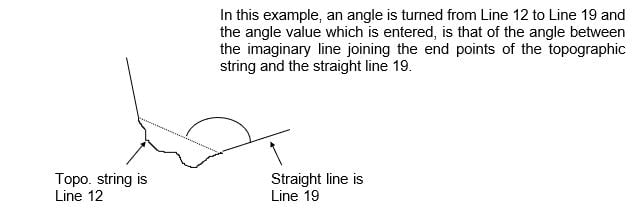
- Angles must be supplied for the internal angle at every point within a polygon. This angle must be the positive, clockwise angle between the line the angle is turned from and the line the angle is turned to.
- Angles turned to or from an arc (lineconst A) must be turned to or from the imaginary chord of the arc. It is not necessary to provide a Line record (Record ID 11) for this imaginary chord. See sketch below:
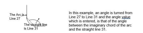
An Angle is required at the end of each arc
Angles turned to or from a topographic string (lineconst T) should be turned to or from the straight chord line joining the topographic string’s two end points. It is not necessary to provide a Line record (Record ID 11) for this line as the distance must be in the line record with a linconst of T.
2.10. Azimuth Record
|
Record ID 14 |
Azimuth Record For an azimuth to exist, the associated line must also exist. Must appear in record order. |
Record example:- 14, 1, 1, 1, 30:45:5, 0.0167, A, M
- The line record and the point record must exist.
- Azimuths supplied in a plane coordinate file as aztype “M” will be treated as bearings, observed azimuths will be maintained as such.
- Only supply azimuths if they are observed or required for plan orientation.
2.11. Circular Arc Record
|
Record ID 15 |
Circular Arc Record To be used when a line defining a parcel's boundary is an arc. For an arc to exist, so must the supporting line. An arc is always defined clockwise. Must appear in record order. |
Record example:- 15, 12, 10.060, 50026.456, 51044.837
For an arc to exist, so must the supporting line. With a line of linconst of: A= clockwise arc
2.12. Topographic String Record
|
Record ID 16 |
Topographic String Record A topographic string is a series of coordinates used to define boundary such as high water mark. For a topographic string record to exist so must its supporting line. Must appear in record order, be sequential and consecutive in the file. |
Record examples:- 16, 43, 1, 50667.345, 51500.835
16, 43, 2, 50654.545, 51534.567
- The line record referenced must exist
- All the internal points of topographical strings must be defined sequentially within each record. The sequence number (strgseqno) must be in order starting from 1, with no gaps in the numbers.
- Points on Topographic strings need to be close enough to represent the boundary; not, as in the past, close enough to merely define a curve to ensure an accurate area calculation.
| ATTRIBUTE | DEFINITION |
| recordid | The record identitification number. |
| loclinno | Local line number representing the string. |
| strgseqno | The sequence number of this particular point within the entire topographic string. |
| xcoord | X coordinate in metres or degrees. |
| ycoord | Y coordinate in metres or degrees. |
2.13. Polyline Record
|
Record ID 17 |
Polyline Record Mandatory for subdivisions. Specifies which lines are used to form a polygon and in what sequence. A polygon is always defined in clockwise order. Must appear in record order. |
Record example:- 17,3,4,16,F
The line and polygon records referenced must exist and the sequence number (polyseqno) must be in order starting from 1 with no gaps in the numbers.
2.14. End of File Record
|
Record ID 99 |
End of File Record Mandatory. Defines the end of the file. Must be the last record. (No blank lines to follow) |
Record example:- 99
2.15. Polygon Naming Convention
Polyident values need to match exactly. Please conform to historic conventions where possible and label creating document when known.
2.15.1. Surround
- A surround polygon/sis required for all CSD files that support the lodgement of a plan
- The surround polygon/s is to encompass the perimeter of the subject area of the plan. For the “SURROUND” polygon Polyident1 must contain the word “SURROUND” in upper case and Polyident2 may contain the numbers of all field record used for the plan of subdivision. Field records registered at the time of plan registration will be added by LANDGATE. Separators of dashes (to indicate consecutive numbers) and commas (for non-consecutive numbers) should be used. E.g. “67120,67122-5,67127”
2.15.2. TLA Polygons
TLA polygons were originally used for Freehold and Strata surveys. They now include Crown surveys, as lots created on a Crown surveys are now referred to as a “lot on plan” instead of a Crown lot type and number (such as, Location, Townsite lot, etc.)
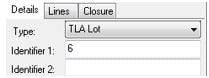
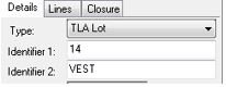
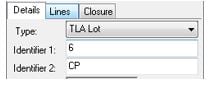
- For New Lots polyident1 is the lot number; polyident2 is not applicable and must remain blank.
- If a lot comprises two or more polygons then there will be a duplication of polytype, polyident1 and polyident2. Additional information relating to multiple segments or part lots is not required. See example for lot 23 below.
2.15.3. Crown Polygons
- These polygons are applicable to historical imported Cadastral Survey Data only. Lots created on Crown surveys are now captured as TLA polygons.
- For Crown lots polyident1 is the lot number and polyident2 is the associated crown lot name.
2.15.4. The Following Applies to all Polygons
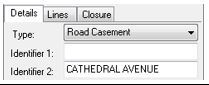
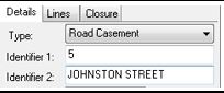
- For road polygons created, polyident1 is to be the road name, or “ROAD 1”, “ROAD 2” etc. if there is a road name approval exemption. polyident2 is not applicable and must remain blank.
- Truncations that form part of the new roads being created are to be treated in the same manners as road polygons.
- For truncations, the polyident1 road name must be the approved road name. “Truncations”. “Trunc” or other similar terms are not acceptable values.
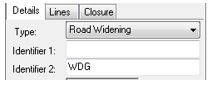
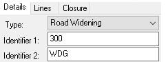
- For road widenings, including truncations, of existing roads, without a Lot Number, polyident1, is blank, polyident 2 is the text “WDG”.
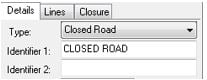
- For closed roads polyident1 is the text “CLOSED ROAD” and polyident2 is blank.
- For easements and portion only covenants and notifications polyident1 is the section and regulation of the relevant act under which the easement, covenant or notification is effective. If an easement or covenant has been created by a deed and no Act applies polyident1 is to be “Doc”. Polyident2 is the lot the easement encumbers, followed by subject then creating document if applicable .
[Lot]-[Subject]
[Lot]-[Subject]-PXXXXXX (max 6 digits)
[Lot]-[Subject]-DXXXXXX (max 6 digits)
[Lot]-[Subject]-SPXXXXXX (max 6 digits)
[Lot]-[Subject]-DPXXXXXX (max 6 digits)
[Lot]-[Subject]-TXXXXXX/YYYY (max 6 digits / max 4 digits)
[Lot]-[Subject]-DOC
[Lot]-[Subject]-DOC AXXXXXX (single letter then max 6 digits)
The combination of polyident1 and polyident2 is restricted to 58 characters
- The polyident1 field is reserved for lot number only (or it may be left blank if not applicable) and the polyident2 field is used in describing the type of lot, purpose or road name.
The following data is an extract of polygon records from a version 2.0 CSD file as illustrated in the tables above.
- 12, 1, 3108.734, 3108.567, F, "34", "", 671, "", ""
- 12, 2, 3107.229, 3126.810, F, "24", "VEST", 680, "", ""
- 12, 3, 3105.629, 3124.210, F, "12", "CP", 870, "", ""
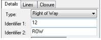
- 12, 4, 3107.429, 3126.833, O, "12", "ROW", 680, "", ""
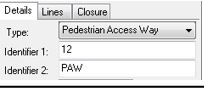
- 12, 5, 3108.758, 3108.502, P, "15", "PAW", 671, "", ""
- 12, 8, 3108.237, 3162.449, R, "5", "JOHN STREET", 633, "", ""
- 12, 9, 3109.237, 3164.345, R, "", "JAMES STREET", 1035, "", ""
- 12, 10, 3107.513, 3144.541, W, "", "WDG", 672, "", ""
- 12, 10, 3107.513, 3144.541, W, "300", "WDG", 672, "", ""
2.15.4.1. Encumbrances1
Polyident1 must match the Land Usage table.
1Table updated to include Community Titles 15/12/2021
Polyident 2 must state the Lot/Location of the encumbrance, the subject area identifier, then the creating document.
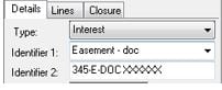
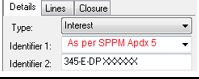
2.15.4.2. Dampier to Bunbury Natural Gas Pipeline Interest Labels2
![]()
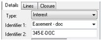
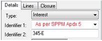
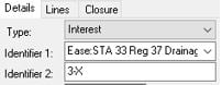
Where the primary interest is an Easement to DBNGP the interests is to be captured as an ‘Easement – Doc’.
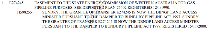
Where the primary interest is an Easement and the under interest is a Sundry to DBNGP the interests is to be captured as an ‘Easement – Doc’.

Where the primary interests is a Sundry then the interest is to be captured as a ‘Notification’.
2Section added 15/12/2001
3. Converting CSD Editor File to Version
It is the surveyor’s responsibility to ensure that the data lodged matches the version format. Any discrepancies will be the surveyor’s responsibility to resolve and may incur requisition fees.
CSD Editor software does not export in 2.0 format by default. To export as different versions, you can ‘convert’ the file. To do this within CSD Editor go to the ‘Edit’ menu and click ‘Convert to version…’.
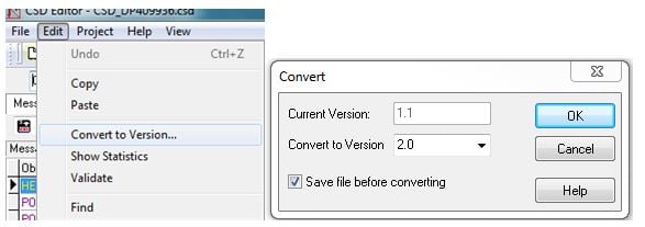
Once the version is set, the individual .dsd file will remain the set version format.
It is highly recommended that the version is converted to 2.0 before making any changes. Changes to some Lot types may not be retained during the conversion process.