This guide is intended as general information only. If you are uncertain of your rights or interests, please seek professional legal advice. Landgate staff are not able to give legal advice or to draft your documents. Please read our Terms of Use above.
Contents
1. Table of Interests and Notifications
2. Terminology for Amending Easements
3. Content and Structure of the Interests and Notifications Schedule
3.1. Existing Interests Being Brought Forward– shown above ‘the line’.
3.2. New Interests and Notifications being depicted- shown below ‘the line’
3.2.1. New Interests
3.2.2. New Vestings
4. Un-dimensioned Memorials and Notifications
5. Multiple Section 167 Easements
6. Private Rights of Way and Implied Rights
7. Bringing Forward Unregistered Easements
8. Transmission Line Easements
9. General
10. Interests Brought Forward on Plans
11. Bringing Forward Anomalous Interests on Plans
11.1. Surveyor’s process
11.2. Guideline 1: Used for Type A anomalies
11.3. Guideline 2: Used for Type A anomalies
11.4. Guideline 3: Used for Type E & F anomalies
11.5. Guideline 4: Used for Type E & F anomalies
11.6. Landgate processes
11.7. Notation/s
11.8. Field Records
11.9. Contacts
13. Bringing Forward Encumbrances- Interests (Burdens & Benefits)- on Crown Land Amalgamation Plans
14. Easements and Covenants Created on Plans
16. Easements in Favour of the Public
17. Crown Easements
19. Graphical Presentation of Easements
21.1. Requirements for Deposited Plans
21.2. General Matters Concerning Interest Only Plans
23. Easements and Notifications Over Vesting Land
24. Subsisting Crown Easements
25. Water Agencies (Powers) Act 1984 Memorials
25.1. Taxes and Charges (Land Subdivision) Legislation Amendment Act 1996 (Deferral of Charges and Headworks Contributions)
25.2. Memorials
25.2.1. Manual Memorials
25.2.2. Automatic Memorials
25.2.3. Removing the Manual Memorial
25.2.4. Removing the Automatic Memorial
26. Notifications of Factors Affecting Use and Enjoyment of Land
26.1. Planning and Development Act 2005
26.2. Transfer of Land Act 1893
26.3. Water Services Licensing Act 1995
27. The Use of Restrictive Covenants/ Covenants to Control Access to Roads
27.1. Under Section 129BA of the TLA
27.2. Under Section 150 of the P&D Act
28. Carbon Rights, Carbon Covenants and Tree Plantations
28.1. Carbon Rights Act 2003
28.2. Tree Plantation Agreements Act 2003
1. Table of Interests and Notifications
Under SmartRegister, Plans prepared by surveyors have an increased role as the Plan is used to provide the graphic for the Title. Deposited Plans need to mirror (reflect) the Register. It is necessary for surveyors to bring forward all existing easements and other interests of a spatial nature (i.e. interests that affect only part of a lot) onto new Plans.
To assist in identifying all the spatial interests on a Plan surveyors are to show the details in a ‘table of interests and notifications’. See plan example 2. The table is to contain a dividing line where all interests and notifications being brought forward are listed chronologically above ‘the line’ and all new interests and notifications are to be shown below ‘the line’ together with any interests being modified.
A parent Title under SmartRegister contains all the ‘live’ interests affecting that Title in the Second Schedule. Surveyors need to identify the best source for the spatial information of each interest and accurately plot the interests on the Plan and include the item in the ‘table of interests and notifications’.
The heading of the table should always be ‘INTERESTS AND NOTIFICATIONS’ regardless of whether it may contain only interests or notification/s.
See APX-08 for a ready reference giving examples of how to present many of the various types of interests and notifications.
2. Terminology for Amending Easements
The following terminology applies to the modification or removal of easements. This terminology should be reflected on Plans where applicable and within the Surveyor’s Report.
- Easements created under section 167 of the Planning and Development Act 2005 – require an application to ‘Extinguish’ or ‘Vary’ under section 167(4)
- Easements created under section 136C of the Transfer of Land Act 1893 – require an application to ‘Discharge’ or ‘Modify’ under section 136J
- Easements created by document – require an application to ‘Surrender’ or ‘Vary’.
3. Content and Structure of the Interests and Notifications Schedule
To provide better clarity and assist in the processing of Plans surveyors are to structure the schedule for interests and notifications in the following manner:
3.1. Existing Interests Being Brought Forward– shown above ‘the line’.
It is only necessary to bring forward interests that affect part of a new lot and it is preferred that these be listed in chronological (i.e. registration) and priority order. The interests currently excluded from this requirement are mortgages, leases, licenses and caveats.
Existing interests that affect whole parcels should not be shown within the schedule as these are automatically carried forward within SmartRegister. Memorials and notifications must not be shown above the line unless there is a spatial component that needs to be depicted.
Mineral reservations must not be shown above the line on Deposited Plans unless there is a spatial component that needs to be depicted.
Profits à Prendre existing over a lot are to be brought forward. Where the Profits à Prendre were created on an Interest Only Plan, there position must be shown graphically, with no dimensions required, and a note in the Comments column of the Interest & Notifications Table on the Plan referring to the creating Plan for dimensions / coordinates. These dimensions / coordinates MUST be shown on the CSD FILE. (Refer to plan example 11)
3.2. New Interests and Notifications being depicted- shown below ‘the line’
APX-08 shows which new Interests and Notifications are to be shown in the “heading” of the Deposited Plan.
These should be listed using the following order of priority.
3.2.1. New Interests
- Easements created on the Plan under section 167 of the Planning and Development Act 2005.
- Easements created on the Plan under Part IVA of the Transfer of Land Act 1893 and/or section 5D of the Strata Titles Act 1985.
- Covenants created on the Plan under Part IVA of the Transfer of Land Act 1893
- New Easements to be created by document as part of the subdivision where the Plan depicts the spatial extent of the easements.
- Other new Covenants to be created by document as part of the subdivision where the Plan depicts the spatial extent of the covenants.
- Other interests (excluding automatic memorials) to be created by document as part of the subdivision. Mortgages, leases, licenses, profits à prendre and caveats are not to be included in the table.
**(Insert a dotted line here to separate the new interests from the new vestings and notifications).
3.2.2. New Vestings
- Lots to be vested in the Crown under section 152 of the Planning and Development Act 2005.
- Notifications under section 70A of the Transfer of Land Act 1893.
- Notifications under section 165 of the Planning and Development Act 2005.
- Automatic Memorials under section 67B of the Water Agencies (Powers) Act 1984 or section 62D of the Water Boards Act 1904.
- On a Plan where there are a large number of interests and notifications to be listed and it is necessary to use more than one table, headings should be added to the tables to clarify whether the items listed are existing or new. See plan example 17.
4. Un-dimensioned Memorials and Notifications
Where possible, surveyors should attempt to avoid situations where memorials and notifications of a spatial nature are depicted on Plans without dimensions. In situations where it is not possible to provide dimensions for memorials and notifications that affect a portion of a lot (e.g. conservation areas) the document needs to contain a sketch of the likely affected area. The memorial or notification needs to be listed in the ‘Interest and Notification Schedule on the Plan with the notation ‘As to Portion Only – Refer document’ placed in the Comments field of the schedule. See plan example 86.
When bringing forward un-dimensioned memorials and notifications that are near or over new boundaries, surveyors should consider the intent of the document and use the best evidence available to ensure that intent is maintained. This may require ground proofing or the use of aerial photography to identify the area and location of the land, the subject of the document creating the memorial or notification. In many cases, the originating agency will have digital data available that will assist in bringing forward an interpretation of the spatial extent.
As a general rule Landgate will not accept for registration any easement or restrictive covenant affecting part of a lot unless it is accurately defined by dimensions.
Where a Part IVA of the Transfer of Land Act 1893 ‘Short Form’ easement is being created on a new Plan of subdivision (with or without an instrument) its purpose must be described as per the relevant easement type listed in Column 1 of Schedule 9A of the Transfer of Land Act 1893. Rights of carriage-way created under section 136C of the Transfer of Land Act 1893 must be described in the schedule of interests and notifications as ‘Rights of Carriage-way’. Any Part IVA easements that do not use Schedule 9 or Schedule 9A must be described in the schedule of interests and notifications as ‘Easement’ only.
5. Multiple Section 167 Easements
Where two or more existing and/or new section 167 easements need to refer to the same regulation number an additional capital letter should be added to the label outside the circle surrounding the regulation number.
It is intended that this requirement applies in situations where there are new and/or existing easements with the same regulation number that need to be distinguished individually on a new Plan.
The need to make this distinction would normally only be necessary where the multiple easements affect a single lot.
Plan example 87 illustrates a situation where there was a need for the easements to be labelled separately. See also section 20.
6. Private Rights of Way and Implied Rights
Surveyors must only bring forward within the Interests and Notifications Schedule those private rights of way that are labelled ‘ROW’ and coloured brown on the original subdivision Plan that created them being the subject of section 167A of the Transfer of Land Act 1893 that affect part of a new lot.
Where abutting land is coloured brown on the original subdivision Plan but not labelled ‘ROW’ it must be labelled exactly as it was shown on the original Plan together with the comment:
“coloured brown on plan/dia ………”
Under no circumstances should any possible implied rights arising from these situations be brought forward and included within the schedule of interests and notifications. See plan example 10, 12, 15, 48, 94 and 96.
7. Bringing Forward Unregistered Easements
Except as outlined below surveyors are required to bring forward onto new Plans any unregistered interests that can be identified from ‘Interest Only’ Plans lodged with Landgate. The new Plans will be placed ‘In Order for Dealings’ subject to the registration of the particular interest.
This requirement does not apply in situations where there is no intention for the interest on the Interest Only Plan to be registered. In this case, a request to have the Interest Only Plan cancelled must be made using the Surveyors Report.
Implied rights-of-way, that affect part of a new lot (see section 167A of the Transfer of Land Act 1893) that have not been extinguished must be brought forward onto new Plans and listed in the table of interests and notifications. See section 6. The lots within the subject of the Plan that have an implied benefit of the easement are to be shown in the schedule under ‘Benefit To’. It is possible for lots appurtenant to a private Right of Way to have both expressed and implied easement benefits over the Right of Way. Where expressed rights exist the Titles are endorsed with the appropriate description. Implied easements over private Rights of Way are endorsed on SmartRegister Titles only.
Titles not yet captured for SmartRegister depict the easement by implication on the sketch in the Title. Surveyors will need to bring forward onto new Deposited Plans any implied easements created by section 167A of the Transfer of Land Act 1893 that affect part of the subject of the Plan. Plan example 21 shows expressed and implied easements over an abutting private Right of Way.
The Planning and Development (Easement) Regulations 1983 require section 167 Easements on Plans to be labelled with the appropriate regulation number within a circle and the associated purpose shown. It is preferred that all other easements be labelled with a capital letter. The use of labels like ‘E-1’, ‘E-2’ etc. is also acceptable. The labels used in the graphic area of the Plan are also to be shown in the table of interests and notifications. See Section 20.
Easements that are created in documents and depicted on Plans must be referred to in the table as ‘Easement’ only.
Easements/Restrictive Covenants created pursuant to legislation must include a reference within the table to the section of the Act (or Regulation) under which they are created.
8. Transmission Line Easements
Surveyors are expected to liaise with the Service Provider and the developer about the timing of the Plan and document lodgement to avoid delays during plan examination.
Surveyors are also referred to Easement Surveys Section 5 for cases where Interest Only Plans are required.
Transmission line easements are to be included in the Interests and Notifications schedule on the Deposited Plans as follows:
- Subject: Relevant Label
- Purpose: Easement
- Statutory Reference: Energy Operators (Powers) Act 1979
- Origin: Doc ( )
- Land Burdened: Relevant Lots affected by easement
- Benefit To: Name of relevant body (e.g. Western Power Corporation)
Plans that include such easements will be placed ‘In Order for Dealings’ subject to Energy Operators (Powers) Act 1979’. See plan example 19.
Easements over Western Power distribution lines are to be depicted and notated as easements under section 167 of the Planning and Development Act 2005.
The most important feature of an Energy Operations (Power) Act 1979 easement, unlike other easements, is that buildings are a permitted encroachment within the easement area.
When depicting these easements on Deposited Plans (including Interest Only plans) or Strata/Survey-Strata Plans, the following should be noted:
- Where the parent lot has no building or structure encroaching into the easement area, the Subject in the Interest and Notification Schedule should be labelled with an Alpha character. For example “A”. No comments are required in the Comments field.
- Where a building or structure does exist within part of the easement area or where a building is proposed to be built within the easement area, surveyors should separately define these areas.
- Within reference to the figure below, “A” and “B” have been adopted for the encroaching buildings and “C” has been adopted for the balance of the easement area. The surveyor may choose to make a comment in the Comments field such as “Building envelope denoted “A” and “B” included in easement area”. The deed will specify details of “A”, “B” and “C”.
The intention of this type of easement by Electricity Networks Corporation is to control the entire easement area and all structures within that area. Where structures do exist, surveyors should include Cross Sections/Elevation Drawings on the Plan displaying RLs defining the vertical extent of the encroaching structure(s). For a complex example see plan example 109.

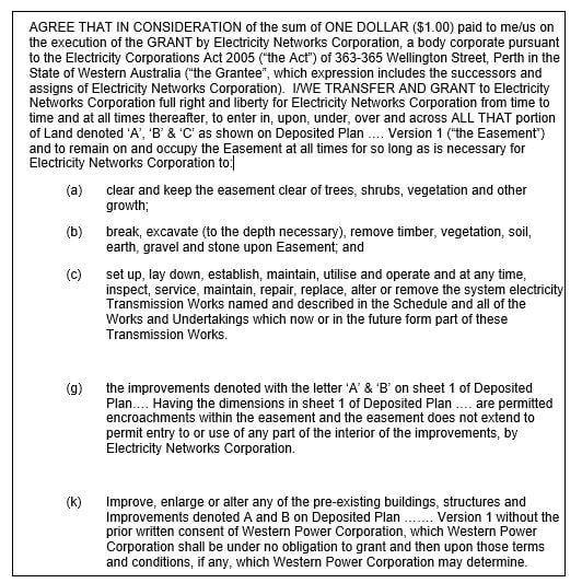
Note: The document refers to Deposited Plan ….. Version 1. If for whatever reason, there is the need for a version change to the Deposited Plan, Electricity Networks Corporation will need to be notified so they can update the document to refer to the correct version.
9. General
Where Instruments are used to define a ‘term’, an expiry date should be specified in the ‘comments’ column.
Where a parcel of land is being subdivided, it is important for the surveyor to ensure that the burden of existing easements and covenants that affect that parcel of land (i.e. within the subject of the Plan) are shown in the table. A surveyor must not seek to interpret or modify the endorsement that is shown on the existing Title and instrument that is being referred to in the table on the Plan.
It is only necessary to bring forward (into the table) a benefit to land within the Plan if that benefit has a spatial nature that exists on a sketch in a paper title or in a document, or on a previous Plan and that benefit needs to be depicted on the Plan. An example of a situation where there is a need to show a benefit over land inside the Plan is where a new lot contains land that was formerly within two previous lots and only one of those former lots had a benefit that is to be brought forward. An implied easement under section 167A of the Transfer of Land Act 1893 that affects part of a lot is also an example of a situation where the benefit needs to be shown in the table and the appurtenance of the private right-of-way needs to be depicted on the Plan. (See Section 7.)
It will not be necessary to bring forward onto the schedule any benefit to land outside the Plan created by existing easements and covenants where the burden of the easement or covenant affects land inside the Plan. A reference is to be made in the schedule to the relevant parent document. Where subsisting benefits are associated with easements and covenants in gross, the beneficiary (as recorded in the original document or Plan) must be shown.
If an existing easement or covenant burdening land outside the Plan is being modified in a spatial manner by a document to be lodged with the Plan and a benefit inside the Plan needs to be identified, the benefit of that easement or covenant needs to be shown in the table on the Plan (below ‘the line’).
Table 14.1 lists the elements to be shown in the table.
The table of interests and notifications can be placed anywhere within the graphic area of a Plan. Where Plans contain many interests and notifications it may be advisable to place the table on a separate sheet for that Plan. A link should be shown in the table to the Plan sheet/s that shows the relevant interest and/or affected lots.
New Notifications under section 70A of the Transfer of Land Act 1893 and section 165 of the Planning and Development Act 2005 are to be included in the table. Lots burdened by the notification are to be shown but the ‘benefit to’ column is to be left blank. The description used on the Plan must match exactly the description used in the notification instrument. If the wording in the description of the notification is lengthy, the description should not be placed on the Plan. (Refer plan examples 14, 16 and 24.)
The Water Corporation have requested that when section 70A Notifications are recorded in the Interests & Notifications table of Deposited Plans the name of the Public Authority be recorded in the ‘Comments’ columns of the table. (Refer plan example 25.) This is particularly important in situations where there may be more than one notification applicable.
Land vesting in the Crown under section 152 of the Planning and Development Act 2005 is to be shown in the table.
Surveyors should avoid overcrowding of the graphic area of a Plan as Landgate is required to place certain statutory endorsements on the Plan and overcrowded Plans are more difficult to comprehend. In some situations it may be worth placing all the graphic representations of the easements and covenants on a separate sheet of the Plan together with the table of interests and notifications.
Where easements, covenants and notifications (either new or existing) affect only a portion of a lot being created, the Plan must show sufficient dimensions to unambiguously identify the land affected.
Where a partial benefit or burden covers a former lot a reference to the former tenure should be made in the table. (Refer plan example 15.) Where any interest or notification, such as a Mineral Reservation or Soil Conservation encumbrance is not dimensioned a reference to a former lot should be made where applicable.
Leases and mortgages that have a spatial nature are not to be brought forward onto new Deposited Plans. This applies in all cases even though sketches on original Titles may show the extents of such interests over the subject land.
Table14.1
10. Interests Brought Forward on Plans
Where it is necessary to bring forward an interest onto a new Deposited Plan of subdivision the depiction of that interest may require an interpretation by the surveyor of the original registered instrument, deed or document.
The endorsements of interests on Certificates of Title refer to the instrument, deed, document, Plan or diagram creating them. Reference should always be made to the instrument, deed, document, Plan or diagram to obtain complete graphical and written information. Surveyors should also refer to the previous paper Titles for graphical information.
Back-captured SmartRegister Titles will normally refer to the previous paper Title as the primary source of the relevant graphic for those Titles. Surveyors should always refer to those previous Titles for graphical information.
The surveyor is entirely responsible for the interpretation of which lots are burdened or benefited especially when an interest comes into close proximity to new lot boundaries created on a new Deposited Plan.
See plan example 98.
11. Bringing Forward Anomalous Interests on Plans
The following advice supersedes Notice to Surveyors T2/2002.
Where surveyors encounter anomalies when bringing forward interests of a spatial nature onto new Deposited Plans and Survey-Strata Plans, the following practices need to be followed.
The anomalous situations that can occur include those where there are discrepancies/omissions in dimensions in the:
- original document creating the interest
- graphic/s on the Certificate/s of Title
- original document with the same dimensional discrepancies/omissions in the title graphic/s
- original document with different dimensional discrepancies /omissions in the title graphic/s
A further situation that can occur is where a modern survey has determined more accurate dimensions for boundaries of parcels and these dimensions conflict with the dimensions for interests intersecting with or related to parcel boundaries depicted in sketches shown in original documents and/or paper Title graphics.
For reference purposes we have described each of these situations as a ‘type’ of anomaly.
Type A
Where a modern survey has determined more accurate dimensions for boundaries of parcels, and those dimensions conflict with the original dimensions for interests intersecting with or related to the parcel boundaries. This is not considered a problem, but it is considered desirable that the parties to the interest are notified about the updated dimensions when the differences are significant
Type B
The Title is consistent (that is appears correct) within itself and differs from the document which is consistent within itself. It will be necessary to determine which is correct, although some examples show that this occurs when a compensating error was made on the Title sketch. If the Title is found to be wrong, it will be a Landgate responsibility to match the Title with the document. If the document is found to be wrong the matter will be referred back to the lodging parties
Type C
The Title is consistent within itself and differs from the document which is inconsistent within itself. This could have occurred when an error in the document was corrected for the Title sketch but not in the document. When the differences are significant it is considered appropriate to notify the parties who may wish to correct the anomaly
Type D
The Title is inconsistent within itself and differs from the document which is consistent within itself. This could have occurred when an error was made on the Title sketch. This is considered a Landgate responsibility to match the Title with the document.
Type E
The Title is inconsistent within itself and agrees with the document which is inconsistent within itself. This could have occurred when an error was made during the preparation of the document. The sketch in the document was faithfully replicated in the Title. This is considered the responsibility of the parties to the interest.
Type F
The Title is inconsistent within itself and differs from the document which is inconsistent within itself. This could have occurred when an error was made during the preparation of the document and another error was made in the Title sketch. This is considered the responsibility of the parties to the interest. Although a subsequent error may have been introduced by Landgate the source document contains discrepancies and this is considered to be where the primary responsibility lies.
Where the above situations occur surveyors must take into consideration the original intention and extent of the interest that was registered. For example, if an interest was originally depicted as extending between two parcel boundaries and a later survey determines more accurate dimensions for those parcel boundaries causing the interest dimensions to alter, the surveyor should reflect the improved accuracy in the dimensions of the interest being brought forward.
11.1. Surveyor’s process
Surveyors are expected to use the following process when bringing forward relevant interests:
- Search the Certificate of Title for a sketch (‘postage stamp’).
- If the Title sketch is consistent and complete and provides a reliable definition there is no need to search further and the Title sketch can be used for the spatial definition of the interest. If the dimensions of the interest are changed because of a more accurate survey (Type A anomaly), guidelines 1 and 2 (see below) apply.
- The document may be searched if desired and Landgate is to be advised via the Surveyor’s Report if any Type B or C anomalies are found.
- If the Title sketch is inconsistent (contains dimensional discrepancies) and/or incomplete (obvious omissions such as angles), the document must be searched.
- If the document is consistent then it can be used for the spatial definition of the interest. Landgate is to be advised via the Surveyor’s Report if any Type B, C or D anomalies are found.
- If the document is inconsistent (types E and F anomalies), Guidelines 3 and 4 are applied as appropriate. Where the parties to the interest include government agencies or corporate utilities, surveyors are encouraged to liaise with them and their client as early in the process as possible to attempt to resolve the discrepancy. In all cases Landgate is to be advised via the Surveyor’s Report of the anomalies and the actions taken concerning resolution of the discrepancy.
11.2. Guideline 1: Used for Type A anomalies
Where the discrepancy in dimensions between a new Plan and an original graphic is the result of a more accurate survey of parcel boundaries and the discrepancy does not exceed the rate specified in section 155 of the Transfer of Land Act 1893 the notation should state:
“The dimensions and position of this type of interest are based on accurate surveyed alignments.”
11.3. Guideline 2: Used for Type A anomalies
Where the discrepancy in dimensions between a new Plan and an original graphic is the result of a more accurate survey of parcel boundaries and the discrepancy exceeds the rate specified in section 155 of the Transfer of Land Act 1893 the notation should state:
“The dimensions and position of this type of interest are based on accurate surveyed alignments as described in field record ______ and an interpretation of document ________.”
11.4. Guideline 3: Used for Type E & F anomalies
Where an anomaly occurs as a result of discrepancies and/or omissions in the original document and/or graphic/s on Certificate/s of Title and the discrepancy does not exceed the rate specified in section 155 of the Transfer of Land Act 1893, the surveyor can bring forward the interest using either:
- The dimensions recorded in the original document and/or Certificate of Title (no Plan notation is necessary in this instance), or
- Dimensions based on an interpretation of the information recorded in the original document and/or Certificate of Title; the Plan notation in this instance should state:
“Discrepancies/omissions in dimensions found in this type of interest within section 155 parameters. Resolution of the anomaly shown in this Plan. See field record ______ and document _______.’
In situations where it is obvious what the correct dimensions in the original document or title graphic should be then surveyors must use the second option.
11.5. Guideline 4: Used for Type E & F anomalies
Where an anomaly occurs as a result of discrepancies and/or omissions in the original document and/or graphic/s on Certificate/s of Title and the discrepancy exceeds the rate specified in section 155 of the Transfer of Land Act 1893, the surveyor can bring forward the interest using either:
The dimensions recorded in the original document and/or Certificate Of Title graphic. The Plan notation (4.1) in this instance should state:
“Discrepancies/ omissions in dimensions found in this type of interest are included in this Plan as it is impracticable/ uneconomical to resolve the anomaly. Boundary intercepts have been interpreted. See field record ______ and document _______.
or
Dimensions based on an interpretation of the information recorded in the original document and/or Certificate of Title. The Plan notation (4.2) in this instance should state:
“Discrepancies/omissions in dimensions found in this type of interest. Resolution of the anomaly shown in this Plan. See field record ______ and document _______.”
In situations where it is obvious what the correct dimensions in the original document or Title graphic should be then surveyors must use this second option.
11.6. Landgate processes
- Surveyor lodges DP that includes notations pursuant to Guidelines 1 or 2 (Type A anomaly).
Plan placed In Order for Dealings with no Landgate investigation. Where Guideline 2 applies, in appropriate cases Landgate will notify the parties to the interest of the situation.
- Surveyor advises Landgate of a Type B, C or D anomaly or uses Guideline 3 (type E or F anomaly) where error <1:500.
Plan placed In Order For Dealings with no Landgate investigation.
- Surveyor advises Landgate of a Type B, C or D anomaly where error >1:500.
- Plan Examiners to verify surveyors report as soon as possible after lodgement.
While plan being examined and awaiting release to WAPC, Landgate carry out actions to place subsidiary endorsements on affected certificates of title and notify the registered proprietors of the burdened and benefited land. The outcome is that the titles will refer to the new deposited plan as being the sketch that defines the spatial extent of the registered interest.
- Surveyor uses guideline 4 (where error >1:500) for a type E or F anomaly.
(i) Where notation 4.1 is used:
(a) Create Registrar’s Packet as soon as possible after plan is lodged to hold affected certificates of title; and
(b) Notify registered proprietors of benefited and burdened land about the situation and advise on options for rectification such as:
- Correction of original documents, or
- Surrender of the interest, and
- Re-creation of the interests with a new document and deposited plan.
(c) Plan can be made in order for dealings within a specified timeframe (usually 21 days from receipt of the Registrar’s letter) depending on the response from the interested parties.
(d) If the surveyor provides evidence at the time of lodgement that the interested parties have consented to the use of this notation, with information about the proposed actions (if any) they are going to take, Landgate will be able to make the plan in order for dealings without creating a Registrar’s Packet and without notifying the parties.
(ii) Where notation 4.2 is used:
(a) Create Registrar’s Packet as soon as possible after plan is lodged to hold affected certificates of title.
(b) Surveyor to provide comments from the registered proprietors of the benefited and burdened land that they have agreed to the resolution shown on the deposited plan.
(c) Plan can be made in order for dealings within a specified timeframe (usually 21 days from receipt of the Registrar’s letter) depending on the response from the interested parties.
(d) If all consents have been lodged with the plan, the plan can be made IOFD in the normal process.
11.7. Notation/s
Notation/s are to be included in the ‘comment’ column of the Interests and Notifications Schedule if there is sufficient space available. Where there is insufficient space available in the Schedule of Interests then a reference (e.g. see plan examples 23 and 97) in the ‘comment’ column to the notation included in the graphical area of the plan may be used.
Table 14.2 can be used as a ready reference for the types of anomalies that can occur and the various actions that need to be taken.
11.8. Field Records
Surveyors must disclose the anomalous situation by recording the following information in a field record lodged at Landgate:
- A sketch indicating where the error/s, omission/s or discrepancies are situated
- Details of any miscloses
- A reference to the document/s and/or Certificate/s of Title where incorrect or discrepant information is recorded
- Where the surveyor makes an assessment of the information and is able to resolve the problem, the field record must include a report on how the matter has been resolved
- Where the surveyor makes an assessment of the information and is unable to resolve the problem, the field record must include a statement as applicable that it was impracticable or uneconomical to resolve the anomaly. The field record must also record how all boundary intercepts were determined.
11.9. Contacts
Table 14.2: Anomalous Interests
| Anomaly | Description | Surveyor | Landgate | Interested Parties |
|---|---|---|---|---|
| Type A | More accurate survey | Difference <1:500: Use guideline 1 |
Plan IOFD with no investigation or other actions |
N/A |
| Difference >1:500: use guideline 2 |
Landgate to notify parties in appropriate cases |
Response not sought or expected | ||
| Type B | Title right; Document right; Title not equal to document | Adopts document. Notifies Landgate via Surveyor’s Report of type B anomaly | Difference <1:500: Plan IOFD with no investigation or other actions. |
N/A |
| Title wrong- Difference >1:500: Examiners check; Plan IOFD; notify parties; endorsement on title to refer to plan |
Response not sought or expected | |||
| Document wrong- Difference >1:500: Examiners check; notify parties; Plan IOFD; endorsement on title to refer to plan |
Respond appropriately to advice from Landgate | |||
| Type C | Title right; Document wrong; Title not equal to document | Adopts title. Notifies Landgate via Surveyor’s report of Type C anomaly | Difference <1:500: Plan IOFD with no investigation or other actions. |
N/A |
| Difference >1:500: Examiners check; Notify parties; Plan IOFD unless objection; endorsement on title to refer to plan |
Respond appropriately to advice from Landgate | |||
| Type D | Title wrong; Document right; Title not equal to document | Adopts document; Notifies Landgate via Surveyor’s report of Type D anomaly | Difference <1:500: Plan IOFD with no investigation or other actions. |
N/A |
| Difference >1:500: Examiners check; Plan IOFD; notify parties; endorsement on title to refer to plan |
Response not sought or expected | |||
| Types E | Title wrong; Document wrong; Title equal to document | Difference <1:500: Use guideline 3 | Difference <1:500: Plan IOFD with no investigation or other actions. |
N/A |
| Difference >1:500: Use guideline 4 | If Notation 4.1: RP, Notify parties; Plan IOFD unless objection |
Respond appropriately to advice from Landgate | ||
| If Notation 4.2: RP, Confirm resolution with parties, unless all consents with plan; Plan IOFD unless objection; endorsement on title to refer to plan |
Respond appropriately to advice from Landgate | |||
| Type F | Title wrong; Document wrong; Title not equal to document | Difference <1:500: Use guideline 3 | Difference <1:500: Plan IOFD with no investigation or other actions |
N/A |
| Difference >1:500: Use guideline 4 | If Notation 4.1: RP, Notify parties, unless all consents with plan; Plan IOFD unless objection |
Respond appropriately to advice from Landgate | ||
| If Notation 4.2: RP, Confirm resolution with parties unless all consents with plan; Plan IOFD unless objection; endorsement on title to refer to plan |
Respond appropriately to advice from Landgate |
12. Bringing Forward Section 27A of the TP & D Act Easements and Section 12A of the TP & D Act Notifications
The Town Planning and Development Act 1928 (TP & D Act) was repealed on 9 April 2006 and replaced by the Planning and Development Act 2005 (P & D Act).
Easements formerly created under section 27A of the TP & D Act are now created under section 167 of the P & D Act, and notifications formerly created under section 12A of the TP & D Act are now created under section 165 of the P & D Act.
The transitional provisions of the P & D Act did not mention section 27A easements or section 12A notifications and did not provide that references to those easements and notifications were to be replaced by references to section 167 easements or section 165 notifications. Therefore, easements originally created under section 27A of the TP & D Act and notifications originally created under section 12A of the TP & D Act before the repeal of the TPDA should still be referred to in the same manner on plans, diagrams, certificates of title and so on, even if those plans, diagrams and certificates of title are replaced or superseded by new or amended versions. In other words, they should be described as section 27A TP & D Act easements and section 12A notifications.
The references on deposited and strata plans, particularly within the interests and notifications schedule, to section 27A easements and section 12A notifications must be made where they have been created before the repeal of the TP & D Act. They should not be changed to refer to section 167 or section 165 respectively of the P & D Act.
The Interests and Notifications ready reference at APX-08 shows the correct format for bringing forward section 27A easements and section 12A notifications.
The beneficiary of these types of interests must be brought forward as shown on the original Plan. If for instance the beneficiary was ‘WAWA’, then this must be shown in the ‘Benefit To’ column of the schedule and not updated to ‘Water Corporation’.
13. Bringing Forward Encumbrances- Interests (Burdens & Benefits)- on Crown Land Amalgamation Plans
Section 87(5) (a) of the Land Administration Act 1997 states that where the whole or part of a parcel of Crown Land is amalgamated with adjoining Freehold Land and ‘if the adjoining land is subject to any encumbrance, that parcel or part becomes subject to that encumbrance as if it had been part of the adjoining land when that encumbrance was created’. When bringing forward encumbrances (interests) with a spatial extent on Crown Land Amalgamation Plans, the requirements of this section must be followed when depicting the extent of any encumbrances. Leases and mortgages that have a spatial nature are not to be brought forward onto new Deposited Plans. (See Section 1.)
14. Easements and Covenants Created on Plans
Part IVA of the Transfer of Land Act 1893 (TLA) enables the creation of easements and restrictive covenants by notations on both Crown and Freehold Survey Plans.
The following easements in short form, as prescribed in Schedule 9A of the TLA can be created on the Plan:
- An easement for a right of footway.
- An easement for water supply purposes.
- An easement for drainage purposes.
- An easement for gas supply purposes.
- An easement for the transmission of electricity by overhead cable.
- An easement for the transmission of electricity by underground cable.
- An easement for the transmission of television signals by underground cable.
- Party wall rights.
- An easement for eaves and gutters.
- An easement for sewerage purposes.
- An easement for motor vehicle parking.
Where there are no other conditions than those in Schedule 9A there is no requirement to lodge an instrument with the Plan.
Schedule 9 of the TLA provides a short form for a right of carriage-way created under section 136C of the TLA (see section 65(2)).
An easement created under section 136C of the TLA cannot burden land outside the Plan but it may benefit land outside the Plan.
Where a Part IVA of the TLA ‘Short Form’ easement is being created on a new Plan of subdivision (with or without an instrument) its purpose must be described as per the relevant easement type listed in Column 1 of Schedule 9A of the Transfer of Land Act 1893. Rights of carriage-way created under section 136C) of the TLA must be described in the table of interests and notifications as ‘Rights of Carriage-way’. Any Part IVA easements that do not use Schedule 9 or Schedule 9A must be described in the schedule of interests and notifications as ‘Easement’ only.
Easements in gross under section 136C of the TLA can only be created in favour of a local government or a public authority. Such easements cannot be created in favour of private corporations such as Alinta Gas, Water Corporation etc. A restrictive covenant can be created by a notation on a Plan under section 136D of the TLA. See plan example 2. The terms of the covenant must be set out in an instrument lodged in relation to the Plan.
Surveyors should avoid extending a benefit of an easement or covenant to many lots outside the subject of the Plan, the written consent of anyone with a registered interest in the benefitted land is required to be obtained. Where the lots receiving a benefit have separate proprietors with different encumbrances (e.g. mortgages), obtaining consents becomes impracticable. Where an access easement is required consideration should be given to changing the easement to a public access easement granted to the local authority under section 136C of the TLA or sections 195 and 196 of the LAA.
Easements that can be created automatically under section 167 of the Planning and Development Act 2005 detailed in the Planning and Development (Easement) Regulations include:
Reg 33a
Easement in favour of a Local Government for drainage access to drainage works or Sewerage
Reg 33b
Easement to Water Corporation for water supply, sewerage or drainage or access to water supply, sewerage or drainage works
Reg 33c
Easement to Electricity Generation Corporation, Electricity Networks Corporation, Electricity Retail Corporation or Regional Power Corporation for electricity supply
Reg 33d
Easement to WA Gas Networks Pty Ltd (or other holder of a distribution licence under the Energy Coordination Act 1994) for gas easement
Reg 33e
Easement to holder of a license for the purpose of the supply of a utility service or access to a utility service. (Easement- Telecommunications Supply Service- e.g. Telstra)
An incorrect or ambiguous statement may not be detected during Plan examination. But after the covenant document is lodged and the Plan is dealt on the inconsistency between document and Plan will cause a requisition and a delay to the dealing. Worse, not all documents are correct when lodged and a combination of multiple mistakes on the Plan statement and a mistake in the covenant document increases the risk of a mistake escaping detection and seriously disadvantaging a purchaser or the developer.
It is vital that the surveyor communicates well with the developer and/or the conveyancer before a 136D statement is placed on the Plan and the surveyor must contribute their expertise to the consultations.
Exact words or expressions only, must be used in a 136D statement. Even the use of accepted legal terms may be incorrect, so words must be used selectively and specifically. The intention must be clear and unambiguous, even if that means using longer explanations or repetition. The term ‘the said lots’ should be avoided where possible as it can be ambiguous.
If there are two or more documents for the covenants on the Plan and they are lodged before the Plan is dealt on, the draftsperson must understand enough to match the right document number to each covenant statement. Transpositions have occurred and this reduces the statements to nonsense or worse. A copy of the lodged documents and the Plan must be obtained and annotations thoroughly checked.
Lots to vest in the Crown under section 152 of the P and D Act must not be burdened or benefited by a covenant. This is a common mistake (on both Plans and documents) which invariably delays dealings.
Where plans include restrictive covenants under section 136D of the Transfer of Land Act 1893, surveyors must lodge a copy of the covenant document with the Form 1C at WAPC. Note that WAPC has advised that if a covenant document includes a provision that in any way limits any future subdivision of a lot then the plan will not be approved by the WAPC.
Lots to vest in or to be transferred to, the Crown other than by section 152 of the P & D Act must not be burdened or benefited by the covenants. (See Section 15.) These may include padmount sites, depending on the developer’s intention. In any case padmounts do not normally receive the burden or benefit of covenants.
A 136D statement on a Plan cannot burden lots that are not on that Plan. See plan examples 2, 22, 24 and 25.
In most of the cases of mistaken 136D statements detected, although the 136D covenant document was registered as a part of the first dealing, the document had been prepared before the Plan was certified correct.
The frequency of mistaken and ambiguous statements and the potential for serious consequences are such that it is recommended that surveyors and solicitors co-operate to provide a covenant agreement and plan that match and meet their client’s requirements.
15. Easements in Gross
‘Easements in Gross’ are very common as Service Authorities recognise the importance of protecting their interests over Crown and Freehold Land.
Also, with the increased regional development of the State private companies are requiring easements for projects such as transmission lines and gas pipelines. These projects are developed in close consultation with Landgate thereby enabling precise definition of parameters for each of them (including survey specifications). An example is the Pilbara-Goldfields Gas Pipeline.
The Spatial Cadastral Database (if spatially upgraded) can be used in conjunction with surveys carried out under either General Regulation 26A or LAA regulation 21(1) to define casements for extensive easements in gross. The Inspector of Plans and Surveys or an Authorised Land Officer must be consulted to obtain prior approval before this method of definition can be used.
See plan example 23 for an example of how to show easements in gross on subdivisional Plans.
16. Easements in Favour of the Public
Easements for the public at large may be created under Sections 195 and 196 of the Land Administration Act 1997. These easements are usually used in shopping centres and provide greater flexibility than rights of way and pedestrian access ways created under section 152 of the Planning and Development Act 2005. See plan example 34.
Section 195 of the LAA makes provisions for easements in gross to the State of Western Australia, a State Instrumentality, Statutory Body Corporation or Local Government.
Section 196 of the LAA further allows the creation of a “public access easement” to the “Public at Large”. This is achieved in conjunction with section 195 of the LAA by the lodgement of a document at Landgate.
Surveyors are reminded that:
- Full details of the easement needs to be shown in the Interest and Notifications table whether the easement exists above the line or below the line. (See the example below).
- Public Access Easements cannot be created under section 136C of the TLA. Sections 195 and 196 of the LAA must be used in all cases
- Public Access Easements can be created on Deposited Plans (including Interest Only plans) and Strata Plans in support of a document
17. Crown Easements
Under Part 8 of the TLA the Minister may grant easements over Crown land (whether reserves or not) to permit works in, upon, through, over or under such land. Examples of these are easements allowing the passage of persons, the provision of sewerage, gas or water pipelines, electrical cables etc., as well as to allow the maintenance of any structure, plant or equipment. There are over 1,000 easements currently registered and most of these are in relation to pipelines of one form or another.
Many easements have also been created over Crown land pursuant to the Petroleum Pipelines Act 1969.
A request for an easement should be forwarded to the relevant Lands Regional Manager in the Department of Planning, Lands and Heritage. See plan example 61.
18. Implied Easements
Section 167A of the Transfer of Land Act 1893 states that every private right-of-way shown on a plan of subdivision shall, unless the contrary is stated, be deemed an easement appurtenant to the land in the Plan that abuts the right-of-way.
Where an implied easement is created on a Plan and an abutting lot with the benefit of the implied easement is subsequently subdivided further, all lots created by the later subdivision retain the benefit of the easement created by the earlier subdivision even though some of the new lots may no longer abut the ROW.
Surveyors are to include in the Table of Interests and Notifications any section 167A ‘implied’ easements affecting part of a lot on the Plan. Refer Section 1 and plan examples 12, 15, 95 and 96.
There are a number of survey documents that have created private roads/access-ways that are not labelled ‘ROW’ and therefore NOT subject to section 167A. These private roads/access-ways are coloured brown on the Plan and either not labelled or labelled ‘Entrance’, ‘Gateway’ or other such variations of descriptive names but are not marked ‘ROW’. (Refer plan example 48.)
19. Graphical Presentation of Easements
The graphical presentation of easements on subdivisional Plans is as follows:
- The extent of the easement must be able to be defined from the Plan.
- Easements parallel and adjacent to a boundary may be dimensioned or shown only as ‘... metre wide parallel easement’.
- Irregular easements must be fully dimensioned.
- The easement label or regulation number must be cross referenced between the table of interests and notifications and the drawn easements. (Refer Section 9 also.)
- Section 167 P & D Act easements are uncoloured in accordance with the Planning and Development (Easement) Regulations. (See Section 14.)
- Where section 167 P & D Act easements are no longer required they may be removed either partially or wholly. The person or authority in whose favour the easement is granted must apply to vary or extinguish the easement under section 167(4) of the Act. Failure to do so will delay the issue of new Titles.
- Where an easement is to subsist or be created over existing pipes that are underground or within buildings and the precise location of those pipes cannot reasonably be determined then the approximate positions must be shown on the Plan together with appropriate notations.
- All surveyed and unsurveyed intersecting boundaries must be shown. These intersections shall include a distance along the intersecting boundary to the nearest corner (drawn - not to scale - if necessary). Ensure that:
(i) Distances on unsurveyed boundaries, shown to the nearest metre are prefixed ‘abt’ (about);
(ii) Unsurveyed pastoral lease boundaries are cast on cardinal bearings;
(iii) Pastoral lease names/numbers, reserves, Crown allotments, UCL, protected roads, water features etc. are to be shown as appropriate; and
(iv) Any SSMs connected to are shown.
20. Labelling of Interests
The Planning and Development Regulations 2009 require section 167 easements on Plans to be depicted on a plan in such a manner as to identify the easement holder. See plan example 6. If two or more existing and/or new section 167 easements need to refer to the same regulation number an additional capital letter should be added to the label outside the circle surrounding the regulation number.
It is intended that the phrase ‘two or more’ be for two or more separate (usually non-adjacent) easements using the same regulation number. It is not intended that this practice be used where an easement crosses a boundary and/or changes direction. The requirement only applies where new and/or existing easements with the same regulation number need to be distinguished individually on a new Plan.
It is preferred that all other easements be labelled with a capital letter. The use of labels like ‘E-1’, ‘E-2’ etc. is also acceptable.
Ambiguous labelling of easements and covenants is to be avoided. If other components in a Plan (e.g. enlargements, cross-sections or access restrictions) require labelling, different letters of the alphabet should be used.
Restrictive covenants that burden whole lots do not require labelling.
21. Interest Only Plans2
If the land affected by an interest that is to be registered is only part of the land in a Certificate of Title (Title) or part of a lot on a plan, then a Deposited Plan and CSD file of the affected land is required to be lodged to support the relevant Instrument except in the following cases:
- When the interest is a caveat, a freehold lease, or a neighbours bore easement.
- When a narrative description referring to a suitable existing Deposited Plan - for example
“as to the portion of land on Deposited Plan … labelled …”.
- When the affected land is part of the land in a Title but is already defined, or can be defined from a compilation of surveys as a separate severance polygon on the Title and in the SCDB, in which case an appropriate description will be required - for example:
“as to the portion of land within Certificate of Title Volume … Folio … bounded by …”.
“as to the whole of lot … on DP … within Certificate of Title Volume … Folio …”
There is a need for certainty of description of the area of land affected by the interest because only one of several interest types can be registered over a piece of land. For example, carbon rights cannot overlap each other, and neither can profits à prendre.
21.1. Requirements for Deposited Plans
- Deposited Plans shall be of Type ‘Freehold’ or ‘Crown’ depending upon the tenure of the subject land.
- The Plan Purpose shall be ‘Interest Only’.
- The ‘Plan Heading’ shall be in the form of ‘Carbon Right/Carbon Covenant/Plantation Interest/Easement and/or other interest over Lot number/Plan prefix and Plan number'; for example: Easement and/or Other Interests over 9000/D6789
- The following information is to be included in an ‘Affected tenure’ table:
- Plan number
- Lot number
- Certificate of Title volume and folio
- Subject land description (optional)
- The statement ‘For Interest Purposes Only’ is to be entered in the ‘Survey and Plan Notation’ field of the plan admin sheet.
- Interest Only Plans are to include an ‘Initial Interests Table’ or ‘New Interests’ table to list all the interests, whether one or many, which are expected to be registered initially over the areas of interest depicted in the interest only Plan.
- The document number will be entered against each listed interest by Landgate at the time of registration.
- Interest Only Plans that support documents for the partial surrender/extinguishment of an existing interest must clearly identify the portions to be surrendered/extinguished and the portions that remain. Only the portions that remain need to be captured in the CSD file.
- As shown in plan example 88, it will generally be sufficient for the position of the area of interest to be defined by coordinates. The coordinates must be expressed in terms of a standard map grid maintained by Landgate e.g., MGA2020, PCG2020. It will be necessary to ensure that the coordinates of the interest polygon and the coordinates used for plotting the boundaries are compatible. Compatible coordinates are those where the accuracy of each set of coordinates is similar and compatible with the relative positions of the relevant entities. If they are not compatible it will be necessary to provide proof that the interest polygon is completely within the subject land. This can be achieved in the following ways:
- by making a geodetic connection to a nearby, verified boundary point and thereby upgrading the boundary coordinates, or
- by re-establishment of nearby boundaries and making a connection to the interest polygon
- If the first case applies, the upgraded boundary coordinates must be shown on the Plan.
- If the second case applies, the connection from the boundary to the interest polygon must be shown by dimensions and the interest polygon must be defined by dimensions. (See plan example 89.)
- Belt planting of trees can be accommodated by using coordinates as illustrated in plan example 90.
- Interest polygons are to be labelled as follows:
- Different interests over the same spatial extent must be captured as separate polygons, and each interest must have a unique label.
- Where an interest has more than one severance, all the severances (polygons) are best labelled uniquely.
- Where an interest has more than one severance, all the severances (polygons) may have the same label.
- Options 15(a) and (b) are available within portal plans.
- Option 15(c) is not available on a portal plan – the plan must be created by CAD software.
- For all options, the digital data (CSD file) must be coded, and the plan presented, such that the allocation of interest polygons to parent lots and relevant documents is correct, complete and consistent.
- Deposited Plans lodged in support of a registered interest will incur the regulated fee for lodging deposited plans.
21.2. General Matters Concerning Interest Only Plans
- It is not possible to create an interest created automatically under any legislation, including TLA, P & D Act, STA and CTA. Such interests can only be created on a subdivisional plan.
- The ‘Interest Only’ Plans are to be regarded as subsidiary to the parent deed. Where a Deposited Plan is lodged it is important that the deed does NOT include a sketch of the interest. It must refer to the lodged Deposited Plan. The process is similar to the current process under Part IVA of the Transfer of Land Act 1893 where a deed is used in conjunction with an easement or covenant depicted on a subdivisional Plan.
- It is essential that the deed firmly links to the ‘Interest Only’ Deposited Plan. The Registrar of Titles strongly recommends Plans to be lodged before deeds are prepared to allow the Plan to be placed in order for dealings.
- The Registrar of Titles strongly recommends all parties retain a copy of the signed deed and a copy of the ‘In Order for Dealings’ version of the Deposited Plan.
- Where extensive easements in gross are being created surveyors are to avoid preparing Plans with more than 4 sheets. In such cases the project should be divided into manageable parts.
- Surveyors are to sign the regulation 54 certificate on ‘Interest Only’ Plans. The certification only applies to the position and extent of the easement or restrictive covenant; it does not relate to the position of the asset or structure within an easement.
- ‘Interest Only’ Plans are to be lodged in the normal manner and surveyors are to lodge CSD files (that conform with the requirements set out in APX-05 Digital Data Requirements) with such Plans.
- The Plans are shown in the SCDB on the Survey Index layers and the normal search fees for Plans apply. Normal lodgement and search fees apply to deeds.
- The spatial extent of all interests created on interest only deposited plans will be depicted in the SCDB on a ‘cadastral polygons’ layer.
- Where an interest is completely cancelled/surrendered only a deed of surrender or similar is required; a Plan will not be required.
- For partial cancellations/surrenders, where 17(a) naming convention is used then an interest only plan is required as described in 21.1.13 above .
- For partial cancellations/surrenders where 17(b) labelling is used, documents can effect the surrender by description. For example, 'Portion (S2) on DP123456'.
- Plan examples 75-84 and 88-92 in APX-04 illustrate the requirements in a variety of situations.
Plan examples 75-84 and 88-92 illustrate the requirements in a variety of situations.
2Section updated 30/09/2022
22. Lodgement of Instruments
Where an instrument is to be lodged to support a Part IVA of the TLA easement or restrictive covenant it must be capable of registration, being in the form of a deed setting out the information required in Sections 136C and 136D as directed by the Registrar of Titles.
Consents of all parties having a registered interest in, or being a caveator in respect of the subject land, must be obtained prior to or included with the application for new Certificates of Title. Where an instrument is used the consents should accompany the instrument.
Where changes are made to a lodged Plan any accompanying instruments must also be amended in accordance with Landgate registration practices, to reflect such changes to the Plan.
The application for a new Certificate of Title and the easement documentation must be lodged together.
23. Easements and Notifications Over Vesting Land1
All interests or encumbrances, other than easements created under section 167 P & D Act, must have approval from the relevant Regional Manager of the Department of Planning, Land and Heritage (DPLH). Evidence of this consent must be provided with the application for new titles, when the documents are lodged at Landgate.
See Land Titles Registration Policy and Procedure Guide SUB-01 13.2 Section 152 of the P&D Act.
1Section updated 29/10/2020
24. Subsisting Crown Easements
Than easements created under section 167 P & D Act, must have approval from the relevant Lands Regional Manager of the Department of Planning, Lands and Heritage prior to submission to the Western Australian Planning Commission.
Subsisting Crown easements are to be brought forward onto Plans in the same manner as private easements and statutory easements in gross. (Refer Section 1.)
25. Water Agencies (Powers) Act 1984 Memorials
25.1. Taxes and Charges (Land Subdivision) Legislation Amendment Act 1996 (Deferral of Charges and Headworks Contributions)
In an effort to reduce costs and improve the availability of developed residential land, changes were made to the way the Water Corporation and other water agencies collect water charges and headworks contributions for newly subdivided land.
The Taxes and Charges (Land Subdivision) Legislation Amendment Act 1996 became effective on 1 July, 1996. The Act amended the Land Tax Assessment Act 1976, the Water Agencies (Powers) Act 1984, the Water Boards Act 1904 and the Water Services Co-ordination Act 1995.
Developers of residential land may apply to the Water Corporation or other water agencies for:
- Exemption of charges for residential lots created by subdivision approved by The Western Australian Planning Commission after 30 June, 1996.
- Deferral of headworks contributions for subdivisions that have headwork contributions unpaid after 30 June, 1996.
In order to obtain a deferral of headworks contributions, the developer must agree to a Memorial being placed in favour of the Water Corporation over each lot where it is proposed to defer headworks contributions.
The deferral applies only if the lot:
- is not serviced and is not a habitable lot,
- is created to be used solely or principally for residential purposes, and
- has an area of not more than 2000m² or if its area is more than 2000m², is to be used for a building or group of buildings that:
- is solely for residential purposes’ and
- contains a number of separate residential units
Payment is deferred until the lot becomes serviced, becomes a habitable lot or one year passes after the subdivisional Plan is approved by the Western Australian Planning Commission. For the purposes of the Act the definition of a lot does not include a lot depicted on a Strata Plan unless it is a lot in a Survey-Strata Scheme.
25.2. Memorials
The Memorials created by the Act can be either lodged in document form or created automatically on the lodgement of the subdivisional plan.
25.2.1. Manual Memorials
Those lodged in document form will follow the same procedures and costs as for any other document lodged at Landgate. The land description must make reference to the parent Title and Plan. The Memorial will be endorsed on the parent Title and brought forward onto the new Titles for the lots on the plan when an application is lodged.
25.2.2. Automatic Memorials
When a plan is lodged with an endorsement that section 67B of the Water Agencies (Powers) Act 1984 applies to certain lots the following will apply:
- The Surveyor will pay a memorial fee when he pays the survey registration fee.
- Landgate staff will check that the fee has been paid and if not will issue an invoice to the Surveyor.
- The parent Title will be endorsed by Landgate with a notation that section 67B or applies. See plan example 2.
- When the survey is In Order for Dealings and an application lodged, Landgate will ensure that the new Titles have a Memorial endorsed upon them.
A plan lodged without an endorsement that section 67B of the Water Agencies (Powers) Act 1984 applies cannot be amended to show such a notation. The benefit of a headworks deferral can still be achieved by lodgement of a manual memorial.
25.2.3. Removing the Manual Memorial
Those Memorials lodged in document form will be removed by the lodging of a Withdrawal of Memorial form that has been prepared for that purpose by Landgate for use by Water Corporation.
25.2.4. Removing the Automatic Memorial
Memorials lodged automatically will be removed by the lodging of an application requesting the Registrar to remove a Memorial created by section 67B of the Water Agencies (Powers) Act 1984.
For each Memorial removed the standard registration fee will apply.
26. Notifications of Factors Affecting Use and Enjoyment of Land
There are three types of notifications created by legislation:
26.1. Planning and Development Act 2005
Under section 165 of the Planning and Development Act 2005 (P & D Act), the WAPC may when it considers it desirable to, have recorded on a Certificate of Title, a notification of a hazard or other factors that seriously affect the use and enjoyment of the land.
The WAPC can have the notification recorded on the above without the registered proprietors consent. Section 165 of the P&D Act can be used by the WAPC as a planning condition before it will give its approval to the plan or Strata Plan.
26.2. Transfer of Land Act 1893
Under section 70A of the Transfer of Land Act 1893 (TLA) a local government or public authority, where they consider it desirable that proprietors or prospective proprietors of land should be made aware of a factor affecting the use and enjoyment of land, may cause a notification to be recorded on any affected Certificates of Title.
The two major differences between the notification under section 70A of the TLA and section 165 of the P & D Act are that the notification under section 70A of the TLA:
- Is much wider in the factors affecting the use and enjoyment of land that may be recorded. It is not limited to hazards or factors which seriously affect the use and enjoyment of land, and
- Consent of the registered proprietor/s is required before the notification can be recorded on Title
In both cases lots that are affected by a notification are to be described on the Plan in the table of ‘Interests and Notifications’. (See Section 1.) The description used on the Plan must match exactly the description used in the notification instrument. If the wording in the description of the notification is lengthy it should not be placed on the Plan. (See plan examples 3, 14, 16 and 24.)
Landgate will make plans that have notifications on them ‘In Order for Dealings’ subject to – (either Sec 165 or Sec 70A)’. By noting these Sections of the Acts on the Plan and Landgate monitoring them, WAPC and other agencies will clear Plans prior to instruments being lodged. An instrument creating the notification must be lodged at the time of application for Titles; otherwise dealings will be stopped and requisitioned.
Where land that is to vest in the Crown under section 152 of the P & D Act the appropriate Lands Regional Manager at the Department of Planning, Lands and Heritage should be consulted before applying a notification to that land.
26.3. Water Services Licensing Act 1995
Provisions in the above Act allow the Minister to make a Transfer Order that transfers the assets of a Statutory Asset Owner to a Transferee. “Assets” as defined in Section 46A of the above Act means any works, or any other thing used or intended to be used for the provision of irrigation or drainage services that:
- is the property of a statutory asset owner; and
- is upon, in, over or under land that is not the property of the statutory asset owner.
27. The Use of Restrictive Covenants/ Covenants to Control Access to Roads
If access is to be restricted onto a road as a condition of subdivision by local government or a public authority, a restrictive covenant in gross should be used- either section 129BA of the TLA (Restrictive Covenants) or section 150 of the P&D Act (Covenants).
The defined boundary portion affected by the covenant is to be labelled (usually a capital letter) and the direction between the points is to shown by arrows. Enlargements should be used where necessary (with the labels added) to clarify the exact position of corners relating to the restricted boundary portion.
Ambiguous labelling of restrictions is to be avoided. If other components in a Plan (e.g. enlargements, cross-sections or easements) require labelling, different letters of the alphabet should be used.
Surveyors are advised that:
- WAPC may impose a condition under section 150 of the P&D Act that access to and from a portion of land shown on a plan of survey related to the subdivision to a road abutting the portion of land is to be restricted.
Section 150 of the P&D Act does not apply to a “future” road/ road widening or a pedestrian access way. A restriction on access in these cases can be effected by a restrictive covenant under section 129 BA of the TLA.
- The notation in the comments field of the Interest and Notifications schedule must specify the following “to and from”. For example:
No vehicular access to and from Great Eastern Highway.
- All new lots created from the parent lot on a plan of subdivision are burdened by the restrictive use that was created by the covenant on the parent lot.
27.1. Under Section 129BA of the TLA
Under section 129A of the TLA the registered proprietor (developer) makes an agreement with the local government or public authority to bind himself and all subsequent registered proprietors not to use a defined portion of the land (usually the boundary between the lot and the road reserve as defined by points on the Plan) for purpose of access to the road. A document is lodged, Restrictive Covenant not shown in heading of Plan. See plan example 3.1.
27.2. Under Section 150 of the P&D Act
Similar to above section 129 BA of the TLA- restriction of access is created automatically on the Plan and referred to as a Covenant. the covenant is shown in the heading of the Plan. See plan example 3.2.
Ambiguous labelling of restrictions is to be avoided. If other components in a Plan (e.g. enlargements, cross-sections or easements) require labelling, different letters of the alphabet should be used.
28. Carbon Rights, Carbon Covenants and Tree Plantations
The Carbon Rights Act 2003 and the Tree Plantations Agreements Act 2003, together with consequential amendments to the Transfer of Land Act 1893 were proclaimed on 24 March 2004. These Acts provide statutory recognition of the creation of some new interests in land that will in most cases where an interest affects part of a lot, involve the preparation and lodgement of Deposited Plans and Cadastral Survey Data (CSD) files in accordance with Section 21. These Plans and CSD files are to be lodged by surveyors accredited with the Land Surveyors Licensing Board as being eligible to verify survey documents.
28.1. Carbon Rights Act 2003
The Carbon Rights legislation creates new rights in land that can be registered on the Certificate of Title for that land. These rights can apply to either Freehold or Crown land and will remain on the Title until it is surrendered by agreement. Where the Carbon Right interest burdens the land in a Title it will be shown as a ‘Primary Interest’ in the Second Schedule of the Title in order of priority.
If the land affected by the Carbon Right is only part of the land in a Title then a Deposited Plan and CSD file of the affected land is required to be lodged to support the Carbon Right Instrument except in the following cases:
- When a narrative description referring to a suitable existing Deposited Plan - for example, ‘as to the portion of land labelled and depicted on Deposited Plan …’, and
- When the affected land is part of the land in a Title but is already defined or can be defined from a compilation of surveys, as a separate severance polygon on the Title and in SmartPlan, in which case an appropriate description will be required - for example ‘as to the portion of land within Certificate of Title Volume … Folio … bounded by …’
There is a need for certainty of description of the area of land affected by a Carbon Right as only one Carbon Right Instrument can be registered over any particular piece of land – carbon rights cannot overlap each other. Land existing as a live polygon or lot on the integrated layer in SmartPlan provides this certainty of description.
Carbon covenants (which may be positive or negative in nature) may also be registered on the Certificate of Title. Where the Carbon Covenant interest benefits the land in a Title it will be shown as a ‘Subsidiary Interest’ to the relevant Carbon Right in the Second Schedule of the Title in order of priority. The Carbon Covenant must be for the benefit of the entire extent of the Carbon Right. Where the Carbon Covenant interest burdens the land in a Title it will be shown as a ‘Primary Interest’ in the Second Schedule of the Title in order of priority. If the Carbon Covenant burdens only part of the land in a Title then a Deposited Plan and CSD file of the affected land is required to be lodged to support the Carbon Covenant Instrument, unless either of the exceptions mentioned above (with respect to Carbon Right instruments) apply.
28.2. Tree Plantation Agreements Act 2003
The Tree Plantation Agreements Act 2003 is complementary to but independent from, the Carbon Rights Act 2003. This Act provides for the creation of a plantation interest as a separate interest in land on registration of a tree plantation agreement on the Certificate of Title. Where the Plantation Interest burdens the land in a Title it will be shown as a ‘Primary Interest’ in the Second Schedule of the Title in order of priority. Where the Plantation Interest burdens a lessee’s interest in Freehold or Crown land it will be shown as a “Subsidiary Interest’ in the Second Schedule of the Title relevant to the lease. If the Plantation Interest only affects part of the land in the Certificate of Title then a Deposited Plan and CSD file of the affected land is required to be lodged to support the Plantation Interest Instrument, as for Carbon Rights and Carbon Covenants mentioned above.