The information provided in this guide is not intended to amount to legal advice. Professional assistance may be required to determine the most appropriate action to protect your legal rights. Please read our Terms of Use on the Community Titles policy and procedure guides web page. Landgate accepts no responsibility where parties print this guide and seek to rely on information that is out of date.
A community titles scheme is comprised of the following scheme documents:
- scheme notice
- scheme plan
- schedule of unit entitlement
- scheme by-laws
1. Scheme Plans (Community Titles Act (CTA) section 37)
The CTA refers to plans for a community titles scheme as scheme plans. There are 2 types of community titles schemes, community titles (land) scheme and community titles (building) scheme - in this guide called a land scheme and a building scheme respectfully. A scheme plan for a land scheme is very similar to a survey-strata plan and a scheme plan for a building scheme is very similar to strata plan.
The surveying and drafting guidelines for scheme plans are identical to those of strata/survey-strata plans and these guidelines can be found in STP-09 Scheme Plans.
The scheme plan numbering is to be taken from the number range pre-allocated to surveyors for strata/survey-strata plans.
For scheme plans that are not portal generated plans, the scheme plan template in the eKit must be used and the following information is to be displayed:
1.1. Plan information
| Tenure Type | Community Titles (Land) Scheme or Community Titles (Building) Scheme |
| Plan Type | Scheme Plan |
| Plan Purpose | Subdivision |
| Tier | 1,2 or 3 |
1.2. Plan heading
A description of the subject of the plan (similar to deposited plans), e.g. Lots 1, 2 and common property (CP3).
1.3. Certificates
1.3.1. Surveyor's certificate
The certificate required to be signed by a licensed surveyor is the standard regulation 54 Licensed Surveyors (General Surveying Practice) Regulations 1961 certificate.
1.3.2. Endorsement Certificate by the Western Australian Planning Commission (WAPC)
As all scheme plans require WAPC approval, the endorsement certificate forms part of the plan template.
Example:
| WESTERN AUSTRALIAN PLANNING COMMISSION | |
| Planning Approval | Yes |
| Reference | 939-29 |
| Delegated under s.16 P&D Act 2005 | Date |
2. Community titles (building) scheme
Scheme plans for a building scheme are where buildings are used to define all or some lot boundaries where either all or some buildings are constructed. They are similar to strata plans in that they have a location and floor plan..
2.1. Location plan
Similar to strata plans, the location plan is designed to show the perimeter of the tier parcel (parcel boundary) of a building scheme, the buildings and the boundaries of part lots external to the buildings in relation to the parcel boundaries. A location plan may be on a separate sheet or can be on the same sheet as the floor plan.
The following information must be shown on location plans:
- perimeter of the tier parcel
- location
- offsets
- extent
- road names
- road widenings (if applicable)
- abutting lot plan numbers
- scale bar
- orientation (consistent with floor plans)
- depth limit (if applicable)
- vesting land (if applicable)
- Interests and Notifications schedule (if applicable)
- Reg. 54 Certificate
Abutting scheme plans should be prefixed ‘SP’ e.g. SP 90000. For community title schemes contained within a single building, abutting schemes will invariably exist above and/or below the scheme plan.
Regulation 25(c) of the Community Titles Regulations 2021 (CTR) states that the plan must specify the relationship of any building on the land to the boundaries of the tier parcel, if the Registrar of Titles requires that to be specified on the plan. With this in mind, surveyors may opt for the location plan to include a 3D component or cross-sectional (isometric) representation of neighbouring community title schemes within the community scheme. It is not a necessity for this sketch to be drawn to scale.
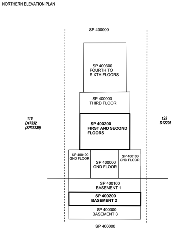
In this example, SP 400000 is the scheme plan for the tier 1 scheme and SPs 400100, 400200 and 400300 are the scheme plans for the tier 2 schemes.
This sketch could include:
- Australian Height Datum (AHD) levels with the point of origin/reference needing to be offsite to assist in the location of each scheme becoming more unambiguous.
- Offsets for the building component of each scheme to the parcel boundary.
If the CDS has something similar as part of its content, then there may be no real need to show this on the location plan.
For building schemes that have parts of lots on more than one floor level (e.g. basement, ground floor & first floor), a table setting out the lot number, total area, floor or level and the sheet number is required to be shown on the location plan (see sample table below):
A CSV file containing this information is required as part of the lodgement of the plan. The CSV file will outline the total area, floors and sheets for each lot as shown in the below table and example:
| CSV Attributes | |
| Attribute | Definition |
| lotident | Lot number |
| areatotal | Total area of Lot |
| floors | Text string of floors for Lot |
| sheets | Text string of sheets for Lot |
Example CSV
lotident, areatotal, floors, sheets
1, 57, "B,G,1", "2,3,4"
2, 77, "B,G,1", ”2,3,4"
3, 79, "B,G,2", ”2,3,5"
4, 55, "B,2,3", "2,5,6"
5, 55, "B,2,3", "2,5,6"
2.2. Offsets/Encroachments
Regulation 25 of the CTR requires that where buildings are closer than 2 metres to a parcel boundary, offsets must be shown on the location plan. Any encroachments onto the adjacent parcel, or road or ROW must be clearly shown by a dashed line. Building connections and wall encroachments should be made to reference mark accuracy. The extent of the encroachment must be dimensioned and the nature and who is to control and manage it (lot owner or community corporation) is to be noted (section 37). Encroachments can be walls, gutters and eaves, awnings, plinths, corbels or other similar building attachments.
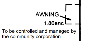
Encroachment on a scheme plan for a building scheme controlled and managed by the community corporation, or
………..a lot owner.
If the encroachment shown on a scheme plan for a tier 2 or 3 scheme is to be treated as common property to be controlled and managed by the community corporation of the scheme to which the tier 2 or 3 scheme belongs (say the tier 1 scheme), this should be indicated on the scheme plan for the tier 2 or 3 scheme. For example, on the scheme plan for a tier 2 scheme, the endorsement could read “to be controlled and managed by the community corporation of tier 1 scheme 400000” or words to that effect.
If an encroachment is to be subject to an easement, the plan needs to specify that easement (CTA section 37). Similar to strata plans, the benefit of this easement must be endorsed on the location plan and an Interest Only Deposited Plan will be required to show the area affected by the encroachment.
2.3. Floor plan
A “floor plan’ is in a plan of the level or stratum and does not have to be confined to the floor of a building. It is a plan view of the base of a cubic space forming a lot or parts of a lot. The perimeter of a building forming the external surface of cubic space should be shown by either a thick
line or parallel (tram) lines to indicate the walls of the building. Usually thinner lines that are dimensioned or partly dimensioned delineate boundaries of part lots that are external to a building.
The floor plan orientation must be consistent with the location plan. The floor plan may be on a separate sheet or, space permitting, included with the location plan.
2.4. Lots
Lots in a building scheme always remain within the confines of the tier parcel boundaries. CTA section 11(14) says that if a scheme plan identifies an encroachment outside the tier parcel that is to be controlled and managed as part of a lot, the encroachment is to be treated as if it were part of the lot.
The area of each part lot should be shown close to the “Pt” lot number. If possible, the lot number and area should be within that specific part of the lot. If, due to lack of space this is not possible the “Pt” lot number and area can be shown externally and then ticked in to indicate the designation of that part. Areas of all the parts should be added to give a total area, which should be shown in brackets within the main “Pt” lot, which is normally, the actual part lot forming or comprised in the building.
2.5. Building lot boundaries in building schemes
CTA section 11(4) specifies the horizontal and vertical boundaries of the cubic space that can form each of the lots by reference to a scheme building to the:
- inner surface of the wall; and
- upper surface of the floor; and
- under surface of the ceiling.
The lot does not include the following:
- space occupied by a vertical structural member, not being a wall, of a building;
- utility conduits except conduits that are for the exclusive use or enjoyment of the lot;
- space enclosed by a structure enclosing utility conduits except such a structure enclosing conduits that are for the exclusive use and enjoyment of the lot.
However, CTA section 11(5) allows a lot to be expressly defined in a manner different to section 11(4) on a scheme plan as long as no part of a lot defined by reference to a scheme building above or below any part of another lot defined by reference to a scheme building.
2.6. Wording for lots in a building scheme
CTA section 37(1)(f) requires lots to be defined on the plan as set out in section 11.
If it is intended to keep the scheme building structure as common property or if it is a high rise building the following wording or wording similar to the following could be used:
- Under section 11(4) of the Community Titles Act 2018, the boundaries of the lots or parts of the lots which are scheme buildings are the inner surfaces of the walls, the upper surface of the floor and the under surface of the ceiling.
and for part lots that are external to the building a wording similar to the following could be used:
- The stratum of the part lots external to the scheme buildings extends between 5 metres below and 10 metres above the upper surface level of the lowest ground floor of the scheme building located on each respective lot except where covered.
For lot boundaries within scheme buildings that are not walls, the following wording would be suitable:
- Under section 11(4) of the Community Titles Act 2018, the boundaries of the lots or parts of the lots which are scheme buildings are the inner surfaces of the walls, the upper surface of the floor and the under surface of the ceiling, except where shown otherwise.
In the scenario where it is intended for a multi-storey tier 2 building scheme created from a tier 1 building scheme lot to have the floor slabs as tier 2 common property, the tier 1 plan would need to show these slabs initially as part of the tier 1 lot. The following wording would be acceptable:
- Under section 11(4) of the Community Titles Act 2018, the boundaries of the lots or parts of the lots which are scheme buildings are the inner surfaces of the walls, the upper surface of the floor and the upper surface of the floor slab above.
This then sets up these floor slabs to become tier 2 common property upon registration of the tier 2 scheme that subdivides the tier 1 lot, in this case lot 5.
Certain schemes will need obvious variations to wordings to fit specific circumstances. It is important that retaining walls, garden brick or stone walls and walls that extend from a building are defined so there is no confusion on ownership.
For a scheme where no lot or part of a lot exists above or below another lot or part lot, wording similar to the following could be used:
Under section 11(5) of the Community Titles Act 2018, the boundaries of the lots or parts of the lots which are buildings shown on the Scheme Plan are the external surfaces of those buildings.
and if applicable,
Where 2 lots have a common or party wall or have buildings on them which are joined, the centre plane of that wall, or the plane at which they are joined, is the boundary.
Unlike strata titles schemes, there are no things identified as being part of a building (downpipes, awnings, hot water systems, air conditioners, etc.) in the CTR so consideration could be given for these things to form part of the description of the building part lot.
In the case where part lots are created outside the building a wording similar to the example below should be used:
The stratum of the part lots external to the buildings extends between 5 metres below and 10 metres above the upper surface level of the lowest ground floor of the main building located on each respective lot, except where covered.
This will ensure the cubic space above and below the buildings remains as common property.
Surveyors and developers may however endeavour to include the areas above and below the buildings as part of the lot. The following wording or similar may be used on the floor plan of the scheme plan:
The stratum of the part lots, including the cubic space above and below the part lots comprising buildings, is limited between 5 metres below and 10 metres above the upper surface level of the lowest ground floor of the main building appurtenant to their corresponding lot number, including where covered.
Note: The above wording is a guide only and may not be appropriate for part lots labelled courtyard; carbay; terrace; balcony etc. Every cubic space outside the building that forms a part lot must be clearly defined with reference to stated surfaces.
Because of the many variations in building schemes, a surveyor may find it necessary to vary the stratum wordings to accommodate the client’s requirements. Surveyors should use their professional judgment and where appropriate obtain legal advice to select the appropriate wording so there is no confusion as to the boundaries.
If surveyors wish, they may reference Australian Height Datum (AHD) level to the floor of a building so the stratum of the scheme can be linked to AHD. This is advisable where accurate height definition is critical or where a building or part of a building is to be demolished and reconstructed. Surveyors should use their professional judgement on these issues.
Generally, the type of information to be shown on the floor plan is very similar to floor plans for strata plans – see STP-09 Scheme Plans.
2.7. Encroachments within a building scheme
In the Strata Titles Act 1985 (STA), permitted boundary deviation means a part of a lot that is above or below another lot in a single tier strata scheme in circumstances allowed by the regulations. Unlike the STA, the CTA does not have the concept of a “single tier scheme” or “permitted boundary deviation”. This means that, for building schemes that define the building part lots to the external surfaces of those buildings, if any part of these buildings encroach into a neighbouring lot, the encroaching portion is not owned by the owner of that building.
CTA section 54(4)(b)(ii) states:
(4) For each lot in a community scheme there is an easement burdening the lot —
(b) if the community scheme is a community titles (building) scheme —
(ii) for the projection over the lot by windowsills, windows, window awnings, eaves, guttering and other minor parts of a scheme building within another lot or the common property.
This means that if there is an encroachment into another lot within the same “single tier” community titles (building) scheme, there is a statutory easement granting the right for the beneficiary of that easement to maintain the encroaching structure. The same applies to any encroachment over common property.
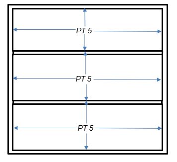
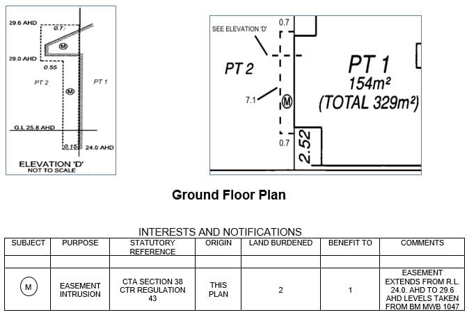
Consideration could also be given to the creation of a short form intrusion easement under section 38 CTA (Regulation 43 of the Community Titles Regulations 2021) to be created on the plan. The details of this easement need to be shown on the floor plan (see below example).
2.8. Common property
CTR regulation 25(f) states that if an area of common property is shown on the plan, that area of common property must be unambiguously shown as common property in a manner approved by the Registrar of Titles.
For instance, in the scenario when a lot in a tier 2 building scheme is bounded by tier 1 and tier 2 common property walls, the floor plan could illustrate this as set out below.
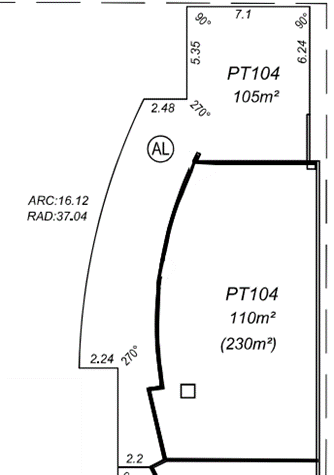

Even though distinguishing between tier 1 and tier 2 common property on the floor plan is not a must, it is strongly encouraged as this would give the owner of lot 104 a clear indication of what their ownership and responsibility for each wall is. This would also be beneficial for insurance purposes.
2.9. Lot numbering
Each lot in a scheme plan or created by an amendment of a scheme plan must have a unique number. The numbering need not start at 1 or be sequential, just unique. If a lot consists of more than one part then the lot number shown on each of the parts must be prefixed by “Pt” (see CTR regulation 23(7)) to indicate that there are other parts forming the lot.
- For building schemes all contained within the one building, serious consideration should be given to numbering each individual lot within the entire building uniquely to assist in the street addressing of each lot.
The Registrar of Titles may, after giving notice to all interested persons, number or renumber a lot defined on a scheme plan or any common property on a scheme plan or created by an amendment of a scheme plan (see regulation 23(8)).
2.10. Common property
CTA section 37(2)(d) provides that the scheme plan for a building scheme may delineate different areas of common property and allocate a reference number (being a unique series of numbers or letters or both numbers and letters) to those areas.
CTR regulation 23(4) states that an area of common property (other than temporary common property) defined on a scheme plan, which includes a plan for a building scheme, may be given a number and regulation 23(5) requires it to be a unique number.
This number is to be prefixed with the letters ‘CP’ and need not be the last number in any lot number sequence, as has been the case historically for survey-strata plans.
2.11. Permit authority certification
All scheme plans for a building scheme must have either an occupancy permit (OP - BA10) or a building approval certificate (BAC - BA14), granted by the permit authority (local government) under the Building Act 2011(BA), and lodged with the plan to enable registration of the community titles scheme.
Surveyors may lodge the scheme plan at Landgate prior to the OP or BAC being signed and issued by the local government. This enables the plan to be examined but not put "In Order for Dealings" while the permit or certificate is waiting to be issued by the local government. Surveyors using this method may lodge the OP or BAC at a later date. However, if the OP or BAC is available prior to the scheme plan being lodged, it should accompany the plan. It is the owner's responsibility to provide their licensed surveyor with a legible OC/BAC.
The following information, key to Landgate’s requirements, will need to be shown on all BA forms:
- the correct scheme plan number and lot on survey details; and
- the name and endorsed signature of the Local Government Issuing Officer along with the date of signing.
Failure to provide this information clearly and legibly will result in the form being rejected and requiring replacement.
As there is a need for consistency for industry groups, local governments, Landgate and the Building Commission, the following rules will also apply:
- All the buildings shown on a scheme plan are to be covered by an OP or BAC.
- Landgate will accept both an OP and a BAC for the same scheme plan where different classes of buildings exist within the same scheme.
- Lot numbers applying to either an OP or a BAC are to be clearly identified.
- Where the information on the OP or BAC is unclear, the lodging party will be notified.
Where the permit authority does not grant an OP or a BAC, the applicant may apply to SAT for a review of the decision under the BA.
3. Land schemes
On scheme plans for land schemes, dimensions provided by a licensed surveyor define the lot boundaries in the scheme. Land schemes may limit the horizontal boundaries of lots by referencing their limits to the (AHD), provided that the land above and/or below these limitations is common property (CTA section 11(6)). It is not possible to create land schemes in which one lot is above or below another lot. These scheme plans are similar in appearance to survey-strata plans.
Each lot and area of common property in a scheme plan or created by an amendment of a scheme plan for a land scheme must have a unique number and be prefixed “CP”. Generally, the type of information to be shown on the plan is very similar to survey-strata plans – see STP-09 Scheme Plans.
3.1. Encroachments
CTA section 37(i) states that a scheme plan must identify the nature and extent of any part of a wall or building or material attached to a wall or building that encroaches on land outside the tier parcel and:
- if an encroachment is to be controlled and managed as if it were common property, or as if it were part of a specified lot or specified lots, in the scheme, specify that fact; and
- if an encroachment is to be subject to an easement, specify that easement.
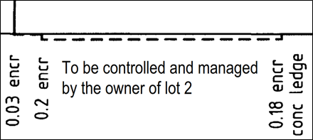
Whereas this requirement in the STA is for ‘built’ strata schemes only to show this information, the CTA requires encroachments beyond the tier parcel to be shown for both building and land schemes. Below is an example of the information that will be required to show the encroachment on the scheme plan for a land scheme.
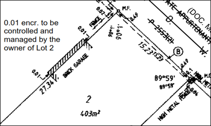
Encroachment on a scheme plan for a land scheme managed and controlled by, in this case, the owner of lot 2 within the scheme.
It is always advisable for an appropriate easement to be registered for any encroachments beyond the tier parcel boundary.
4. Easements
A scheme plan may:
- delineate or record easements (other than statutory easements) and restrictive covenants over the tier parcel, including —
- short form easements or restrictive covenants created under CTA section 38;
- easements created under P&D ACT section 167; and
- easements and restrictive covenants created under TLA section 136 and Part IVA.
Easements that are created under the P&D Act, TLA or the CTA need to be shown in an Interests and Notifications schedule/New Interests schedule on the plan and be shown by broken lines, dimensions and angles on the plan. Original easements and covenants being brought forward also need to be shown.
4.1. CTA short form easements (CTA section 38)
Under the CTA it is possible to create short form easements and restrictive covenants over land in the same ownership. This has numerous advantages where a developer may put in place easements and restrictive covenants for various purposes over the subject land at the time of registration of the scheme.
Easements created pursuant to CTA section 38 are created automatically on registration of the scheme or an amendment of a scheme effecting subdivision. This can eliminate the need for any written documentation. The short form description of the easement, easement types and the rights and liabilities are all prescribed in the CTR. The short for description of the easement is shown on the scheme plan. These types of easements are confined to the subject land, i.e. it is not possible to benefit land outside of the scheme.
The following are the short form easements that may be created on the scheme plan under CTA section 38:
- vehicle access easement under CTR regulation 40
- light and air easement under CTR regulation 41
- party wall easement under CTR regulation 42
- intrusion easement under CTR regulation 43
- pedestrian access easement under CTR regulation 44
- easement in gross under CTR regulation 45
- easement for utility services under CTR regulation 46
If special conditions are required, the standard form of the easements may be varied by lodging a memorial or instrument that sets out the specific conditions before the plan is registered. The CTR defines a “short form document” to mean:
- A scheme plan or amendment of a scheme plan; or
- A memorial or other instrument lodged with a scheme plan or relevant amendment of a scheme plan.
Easements created under CTA section 38 may be varied or discharged under CTA section 38(6)(a) (see EAS-03 Removal of Easements).
When dealing with vehicle access (Reg 40) and pedestrian accessway (Reg 44) easements, the CTR provides for these easements to be ‘exclusive’ or ‘non-exclusive’. This needs to be stated in the ‘Comments’ column of the Interests and Notifications Schedule (see E in the table example below). If the easement is exclusive, the grantee must keep the easement area in good order (including by doing any repairs, replacements, maintenance, cleaning or other upkeep).
- CTR Regulations 40 and 44 define “exclusive” as for the exclusive use of the grantee to the exclusion of the grantor”.
If the easement is to be non-exclusive:
- the grantor will need to keep the easement area in good order (including by doing any repairs, replacements, maintenance, cleaning or other upkeep); and
- the grantee will be required to reimburse the prescribed proportion of the costs incurred by the grantor in keeping the easement area in good order.
The prescribed proportion will be:
- the proportion that the unit entitlement of the grantee’s lot bears to the total unit entitlements of the grantor’s and the grantee’s lots, or
- if common property is burdened by the easement, the proportion that the unit entitlement of the grantee’s lot bears to the sum of the unit entitlements of all lots in the community titles scheme; or
- if common property is benefited by the easement, the proportion that the unit entitlement of the grantor’s lot bears to the sum of the unit entitlements of all lots in the community titles scheme.
If the apportionment of upkeep is not to be the prescribed proportion, the desired proportion is to be specified in a memorial or instrument (short form document) lodged at Landgate.
4.1.1. Easements in gross (CTR regulation 45)
The short form documents may describe the terms of the easement by reference to a:
- planning condition,
- statutory provision or
- contract.
If the terms of the easement are to be contained in a planning condition or contract, to enable visibility and searchability of the terms, the CTR enables a copy of the contract, statutory provision or planning condition to be contained within a memorial or instrument lodged with the application to register the scheme or amendment of scheme (short form document).
If the easement expires at the end of a particular period, that period must be specified in the short form document.
An easement in gross can only benefit a local government, public authority or utility service provider specified in the short form documents and cannot benefit a lot or common property within a scheme.
4.1.2. Easements for utility service (CTR regulation 46)
Utility Service
- water supply
- drainage
- gas supply
- transmission of electricity by overhead cable
- transmission of electricity by underground cable
- transmission of communication signals by overhead cable
- transmission of communication signals by underground cable
- sewerage
- generation, storage or conservation of energy
The rights conferred by the easement are set out in CTR regulation 46 and are very similar to the rights set out in TLA section 136C and Tenth Schedule with the addition of an easement for generation, storage or conservation of energy, which creates the following rights:
- to make surveys, clear lines of sight, take levels, make or set up beacons, trenches or other marks, sink bores, take soil or other samples and do any other acts or things necessary for the investigation or demarcation of the easement area; and
- to construct and install generating works and apparatus in the easement area; and
- to construct other works (such as fences and access tracks) in the easement area for the purpose of ensuring the safe, secure and reliable operation of the grantee’s generation, storage or conversion of energy system; and
- to inspect, alter, maintain, repair and replace generating works, apparatus and other works referred to in paragraph (b) and (c); and
- to use the generating works, apparatus and other works referred to in paragraphs (b) and (c) for the purpose of generation, storage or conversion of energy and ensuring the safe, secure and reliable operation of the grantee’s generation, storage or conversion system; and
- to break the surface of, dig, open up, remove, store or use any earth, stone, gravel, sand or other soil, vegetation or obstructions in the easement area and use the easement area for any of the purposes in paragraph (a), (b), (c), (d) or (e); and
- to enter a lot or common property burdened by the easement for any of the purposes referred to in paragraphs (a) to (f).
However, unlike TLA section 136C, the CTA doesn’t require the written consent of any person who has a registered interest or is a caveator in respect of the land being burdened by the easement. The consents required under the CTA are from the holders of type 1 or 2 interest, which are defined in the CTA as:
Type 1
- the interest of a person who holds the remainder or reversionary interest in land comprised of a lot in a community titles scheme in a case where the owner of the lot holds a life estate in the land; or
- a registered mortgage; or
- the interest of a judgment creditor named in a property seizure and sale order registered under TLA section 133; or
- the interest of a person named in a memorial registered under the TLA as having a statutory right requiring the consent of the person to any dealing with the land; or
- a plantation interest registered under the TLA; or
- a carbon covenant registered under the TLA;
- a carbon right registered under the TLA;
- a profit à prendre registered under the TLA;
Type 2
- a registered lease; or
- a caveat recorded under the TLA;
This could be considered as a viable option when creating utility service easements on community titles schemes where an estate covenant exists on the parent title and all the lots created on the Deposited Plan of the parent lot are benefitted and burdened by this covenant.
4.1.3. Example Schedule of Interests and Notifications
INTERESTS AND NOTIFICATIONS
| SUBJECT | PURPOSE | STATUTORY REFERENCE | ORIGIN | LAND BURDENED | BENEFIT TO | COMMENTS | |
|
EASEMENT (VEHICLE ACCESS) |
CTA SECTION 38 REG 40 |
THIS PLAN | LOT 1 | LOT 2 | |||
|
EASEMENT (LIGHT AND AIR) |
CTA SECTION 38 REG 41 |
THIS PLAN | LOT 1 | LOT 2 | |||
|
EASEMENT (PARTY WALL) |
CTA SECTION 38 REG 42 |
THIS PLAN | LOT 2 | LOT 1 | |||
|
EASEMENT (INTRUSION) |
CTA SECTION 38 REG 43 |
THIS PLAN | CP3 | LOT 1 | |||
|
EASEMENT (PEDESTRIAN ACCESS) |
CTA SECTION 38 REG 44 |
THIS PLAN | LOT 2 | LOT 1 | THIS EASEMENT IS EXCLUSIVE | ||
|
EASEMENT (DRAINAGE) |
CTA SECTION 38 REG 45 |
THIS PLAN | LOT 2 | CITY OF STIRLING | |||
|
EASEMENT (GAS SUPPLY) |
CTA SECTION 38 REG 45 |
THIS PLAN | LOT 2 | ATCO | EXPIRES ON 31.12.2050 | ||
|
EASEMENT (WATER SUPPLY) EASEMENT (DRAINAGE) EASEMENT (GAS SUPPLY) EASEMENT (TRANSMISSION AND DISTRIBUTION OF ELECTRICITY BY OVERHEAD CABLE AND CONDUCTORS) EASEMENT (TRANSMISSION AND DISTRIBUTION OF ELECTRICITY BY UNDERGROUND CABLE AND CONDUCTORS) EASEMENT (TRANSMISSION OF COMMUNICATION SIGNALS BY OVERHEAD CABLE) EASEMENT (TRANSMISSION OF COMMUNICATION SIGNALS BY UNDERGROUND CABLE) EASEMENT (SEWERAGE) |
CTA SECTION 38 REG 46 |
THIS PLAN | LOT 2 | CITY OF WANNEROO | |||
5. Restrictive Covenants
These are a restriction on the land and can be utilised for such things as building restrictions, height restrictions and limitations on building materials, aesthetics and similar controls on appearance, access and use of the land. Restrictive covenants can be created on the scheme plan (TLA sec 136D, CTA sec 38 and P&D Act sec 150 P&D) or by deed (TLA sec 129A and 129BA). These types of covenants can be between lots within a community titles scheme or benefits may be given to land outside the scheme or public authority/local government.
An important feature of TLA sec 136D and CTA sec 38 restrictive covenants is that they have effect even while the land burdened and benefited are in the same ownership.
CTA sec 38 provides that restrictive covenants can be created on the scheme plan benefitting local governments and public authorities only. CTR regs 52 to 56 sets out the short form purpose, rights and liabilities of the restrictive covenants:-
- Right of way restrictive covenant - to prevent development in a right of way setback
- Land use restrictive covenant - to restrict the use of land
- Conservation restrictive covenant - to protect areas identified for conservation
- Building envelope restrictive covenant - to control the siting of development
- Fire restrictive covenant - to restrict development in fire prone areas
The rights and liabilities of these restrictive covenants may be varied by a memorial or other instrument lodged at Landgate. For Land use and Conservation covenants, a memorial or other interest will be required to provide more specifics in regard to the restrictions on land use and conservation.
INTERESTS AND NOTIFICATIONS
Alternatively, restrictive covenants may be created under TLA section 129A using an instrument. It is also possible to benefit land outside of the scheme by utilising this method. This means a lot within a community scheme may be encumbered by a covenant, but land outside the scheme may benefit from that covenant.
A local government may impose a covenant under TLA section 129BA as a condition of subdivision over a portion of a proposed lot abutting a Right of Way, Way or Lane in order to prevent new developments taking place over a prescribed portion of the subject land. Such restrictions are usually used to accommodate future widening of the Right of Way. Surveyors must show the extent of the restrictive covenant spatially on the plan and endorse the covenant in the Interests and Notifications Schedule.
P&D Act section 150 allows road access conditions, imposed by WAPC, to be endorsed on scheme plans. Conditions imposed as a restriction or prohibition on land abutting a road is to be shown in the Interests & Notifications schedule as a “COVENANT”.
Regulation 30 of the Planning and Development Regulations 2009 is used to impose road access conditions. A road access condition must be identified and labelled with such a notation as A – B. Details of the restriction or prohibition and to whom or what it applies and when and in what circumstances, is to be noted in the COMMENTS field of the Interests & Notifications schedule on the plan.
The covenantee can only be one of the following:
- Western Australian Planning Commission
- Commissioner of Main Roads
- Minister administering Public Works
- Local Government
Surveyors are advised that:
- WAPC may impose a condition under P&D Act section 150 that access to and from a portion of land shown on a plan of survey relating to the subdivision to a road abutting the portion of land is to be restricted. P&D Act section 150 does not apply to "future" road/road widening or a pedestrian access way. A restriction on access in these cases can be effected by a restrictive covenant under TLA section 129BA.
- The notation in the comments field of the Interests and Notifications schedule must specify to the following "to and from", e.g. NO VEHICULAR ACCESS TO AND FROM GREAT EASTERN HIGHWAY.
- All new lots created from the parent lot on a plan of subdivision are burdened by the restrictive use that was created by the covenant on the parent lot.
Note: P&D Act section 150 does not replace restrictive covenants created under TLA section 129BA TLA but should be shown in the same manner.
A road access condition covenant can be modified or discharged under regulation 32 of the Planning & Development Regulations 2009 by application to WAPC. When consent has been granted, an application is made to the Registrar of Titles to modify or discharge the covenant accordingly and make any entries or endorsements that may be necessary to evidence the modification or discharge.
Any modification of a spatial nature would require an Interest Only Deposited Plan to accompany the Application to modify the covenant.
An appeal to SAT is available to an applicant if WAPC refuses a request to modify or discharge a Road Access Condition covenant.
6. Restricted Use Condition
A restricted use condition restricts the purposes for which the whole or a part of the parcel may be used (a restricted use condition). This may be a requirement stipulated in the CDS.
Any scheme plan or amendment of scheme plan that is lodged for registration may restrict the purposes for which the whole or part of the parcel may be used. This is achieved by an endorsement on the plan that delineates the area affected and that makes specific reference to CTA sec 37(2)(a). In most cases, these restricted use conditions are related to land use and could be a condition of planning approval, for example a retirement village.
Surveyors adding a restricted use condition to the plan should use an endorsement that clearly specifies the restriction type and the lots or parts of lots affected. If it affects part of the land, the affected part is to be defined in the same manner as an easement boundary and noted on the face of the location/floor plan.
There are benefits from a planning perspective because variation or removal requires WAPC consent.
Carefully planned restricted use conditions can assist greatly in the successful and orderly management of a community titles scheme. Monetary penalties may be imposed where an owner or occupier of a lot contravenes the restricted use condition (CTA section 70).
It is advisable to consult WAPC as to the wording it prefers for a restricted use condition.
- Note: A restriction of the kind referred to in CTA Section 37 is a restriction as to the use or use and occupation of the land in the community titles scheme, not a restriction on the ownership of the land in the scheme.