This guide is intended as general information only. If you are uncertain of your rights or interests, please seek professional legal advice. Landgate staff are not able to give legal advice or to draft your documents. Please read our Terms of Use above.
1. Disclosure
General Regulation 4 and TLA regulation 2 confirm the professional responsibilities of surveyors to disclose information and to act in the interests of the State.
Particular examples of these requirements, and which the surveyor should consider and disclose, are:
- Easements (whether documented or apparent).
- Presence of encroaching power lines.
- Encroachments, including positions of fences.
- Other irregularities which may affect title.
2. Minimum Acceptable Re-establishment
Sufficient permanent marks should be found to provide enough redundancy:
- To prove that none of the adopted marks could have moved,
- To prove that there was not a mistake in the original work and to allow distribution of the errors in that work, and
- To detect any mistakes in your own work and manage the errors.
The above criteria are necessary for every original alignment of the subdivision, although reduced a little for successive alignments because of redundancies provided by the other alignments.
General Regulation 23 requires at least three well-spaced marks in agreement. Two unsupported intersection spikes is not sufficient pickup. Intersection spikes referenced only by a spike protection that did not verify the alignment are considered to be unsupported.
In Special Survey Areas the pickup is to include at least three PSMs or PCMs in agreement.
3. Urban Re-establishment
A surveyor, when subdividing or re-marking all or a portion of a lot abutting on a road where the total distance between the road corners disagrees with the original subdivision (whether Crown or otherwise) by more than one part in eight thousand should re-establish sufficient of the section to prove the marks found; allow the distribution of excess or deficiency; and allow the calculation of all of the boundaries of the old allotment. The ratio of 1:8,000 should be substantially tightened in commercial areas.
Substantial improvements on or near the boundaries of nearby lots (and that may be affected by the distribution of excess or deficiency) should be located. Suitable measurements from existing lodged surveys may be used to assist in meeting the requirements of this guideline.
Guidelines under General Regulation 22B issued by the Land Surveyors’ Licensing Board outline how Standard Survey Marks can be used for re-establishment.
4. Priorities of Re-establishment Evidence1
The following order of priority of evidence is recommended in re-establishing street corners:
- Reliable marks or monuments (i.e. connections to buildings etc.) on the subject alignment.
- Reliable marks/monuments on other side of the road. Then using original connections across road.
- Proportioning distances (whilst maintaining alignment) over two or more sections. This method is usually only reliable when both sections are part of the same original survey but it is the only method to be used where deficiencies are involved.
- Proportioning distances whilst maintaining original angles within the street section.
- Maintaining original distances.
- Maintaining straight street alignments.
- Producing street alignments.
- Maintaining original angles.
Items 3 - 8 are mathematical solutions and must be considered together with improvements on or near boundaries and previous surveys carried out within the section.
Where marks at a bend or a series of bends are gone, the corner/s can be refixed by adopting the original angle/s at the bend/s to be re-established and proportioning the distances between the marks found. See Section 5 Lost Corner Restoration for guidance.
1Section updated 15/07/2022
5. Lost Corner Restoration - Refixing Lost Corners2
A fairly common problem for surveyors is to refix, or restore, the positions of lost corners. A typical scenario is where a subdivision falls between two corners that have lost the RMs, and RMs are found at other corners either side of the subject parcel. The recommended technique is shown at Figure 1 below.
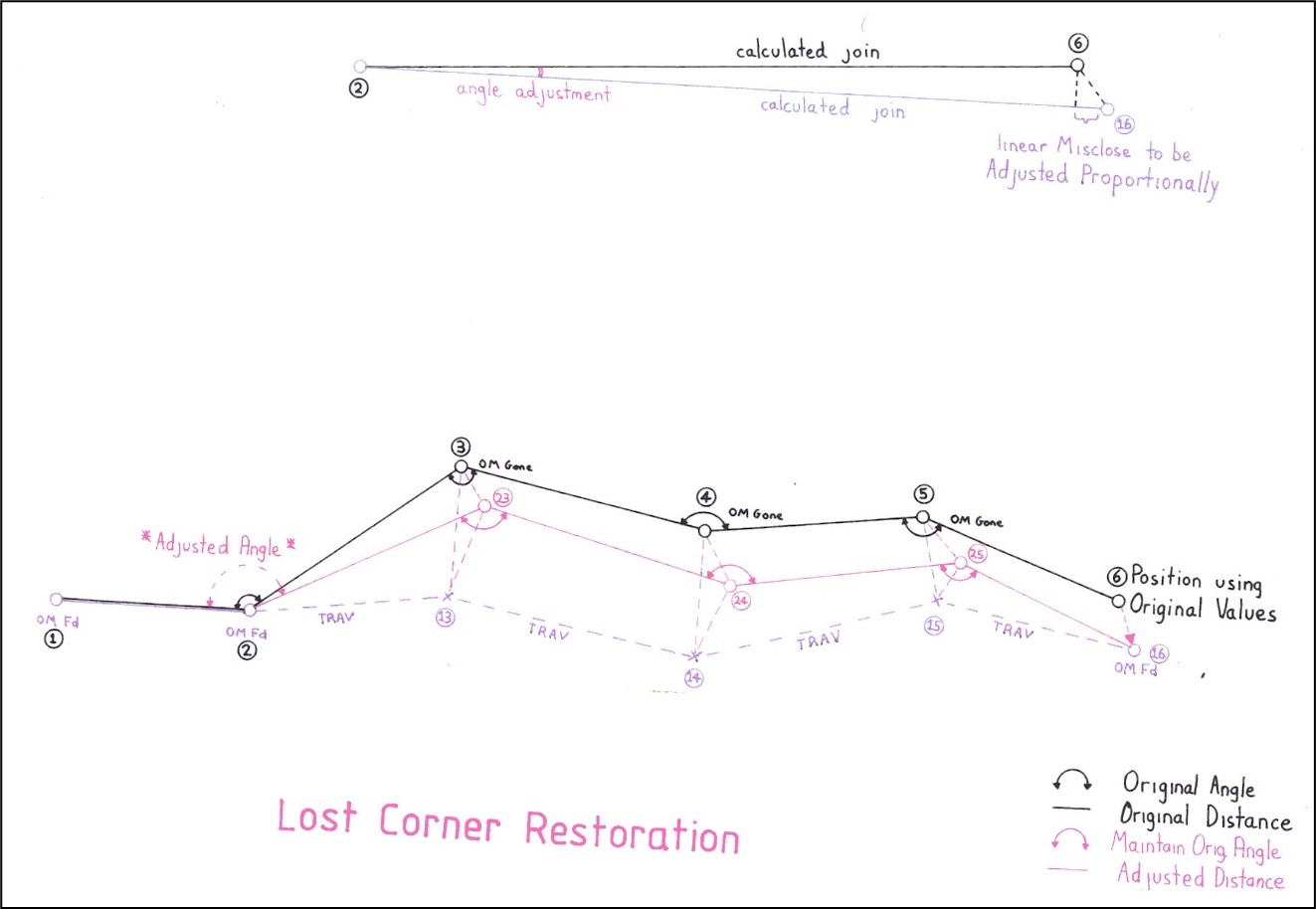
Figure 1
The join between the two known points is calculated from both the current measurements and from the original values. The linear difference between the two results is proportioned evenly, and the angular difference is taken up in the first angle. All other angles are kept as original.
The following lodged field record illustrates the process (see figures 2 and 3 over the page).
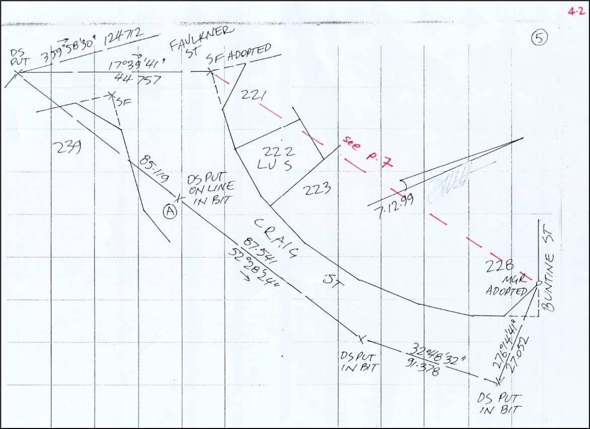
Figure 2: The relationship between the two fixed end points is determined by traverse
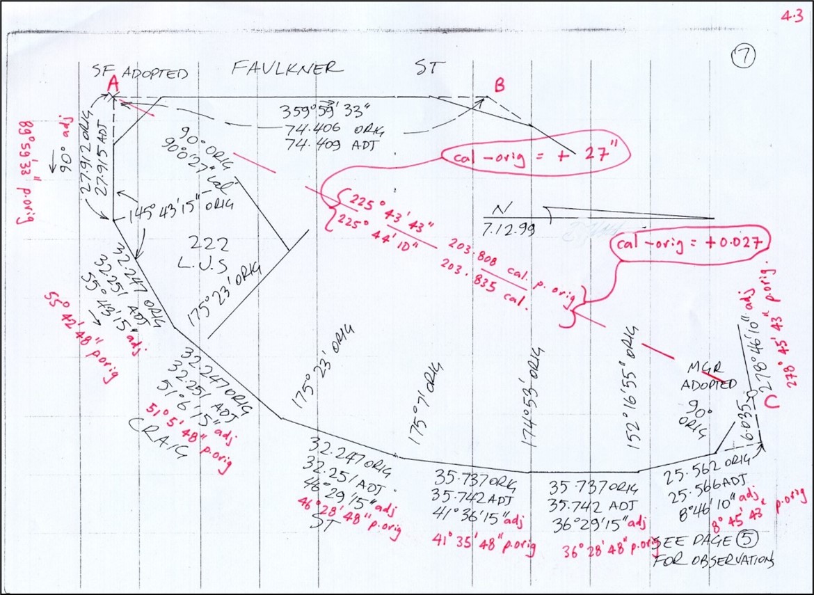
Figure 3: The join between the end points is compared to the original values. The difference in distance is proportioned evenly, and the original angles are held fixed. All of the angular adjustment is put into the first angle.
2Section added 15/07/2022
6. Excess Adjacent to Deficiency
An excess distance should not be created adjacent to a deficiency unless this is made necessary by reliable marks at the corner being re-established. In all other circumstances every effort should be made to minimise the deficiency as a first priority. An excess adjacent to a deficiency usually indicates an error in the method of re-establishment (see section 3 above).
7. Conformity between Adjacent Plans
In surveys carried out by traditional conventional means it has been accepted that adjacent surveys separated by a period of years can differ in their re-establishment of their common alignment.
Because each was based on direct measurements to original marks found the differences were (and still will be) accepted.
The situation is different when:
- modern methods using a control survey are used
- the original marks can be subject to disturbance during the construction phase of the subdivision, and
- the field records are necessarily summarised.
In the case of large urban subdivisions (especially Special Survey Areas) it is not acceptable for adjacent surveys to differ in the dimensions of their common boundary without justification for the adoptions and resolution of the discrepancy, particularly when both adjacent surveys were carried out by the same firm or used a common control network. It is the surveyor's responsibility to ensure that the definition of the common boundary is reliable.
8. Closest Pickup is Best
In resolving difficult re-establishment problems, apparent from large differences from original in recently lodged surveys, the inspecting surveyors are usually able to find reliable original marks close to the subject survey (but which were not found or used by that surveyor). The use of these extra marks usually resolves the problem simply.
The closest original marks should always be used (not necessarily adopted); and a determined search for all close marks should be made when there seem to be significant differences from original dimensions.
9. Discrepancies with Original
All discrepancies with original values outside regulatory limits should be fully investigated with adoptions, measurements, offsets and calculations checked. Where re-established corners do not fit with improvements (e.g. fencing) there is a risk that an error has been made and therefore it is recommended that adequate check measurements be undertaken. Included Angle is a Check Only
In re-establishing adjacent street alignments of an urban section with sparse pickup, agreement with an original angle alone is an unreliable basis for re-establishment. Commonly both adopted alignments are incorrect by amounts that compensate in angular terms. Use the angle only as a check, not as a basis for re-establishment.
Adopting original angles and thereby causing deficiencies on original distances should be avoided, however in some old rural areas the original angles may be more reliable than the original distances.
10. Erroneous Original Values
Where it is found that an original ‘legal’ dimension of the parent parcel (ie. shown on latest plan) is in error it is recommended that the relevant adopted corners of the parent parcel are re-marked to enable the correct dimensions to be shown on the plan that is to be lodged.
11. Calibration of Instruments
Calibration of measuring instruments is particularly important when the function of measurement is hidden from the surveyor who must simply rely on the manufacturer's claims. Regular calibration of EDM units, total stations, electronic theodolites and GPS receivers should be an integral part of the measurement process. It is an important part of a surveyor's quality control system and provides legal traceability back to the national standard for length measurement.
As well as the particular recommendations of the manufacturer, client or employer (and as well as any needs dictated by accident, transport, repair or loss of control over the instrument) electronic measuring instruments should be calibrated at least once a year. Historical as well as current calibration records should be retained and may be required to be produced to support a lodged survey.
Log on to My Landgate Survey Channel for current details about the calibration facilities and services available in WA.
12. Accuracy
To maintain accuracy of angular and linear measurements, procedures should be adopted such that:
- the standard deviation of an angular measurement should not exceed + 10” of arc; and
- the standard deviation of a distance measurement should not exceed + 1:16,000 of the distance on an urban survey or + 1:10,000 of the distance on a rural survey.
If the standard deviation calculated from either of the above ratios is less than 5 millimetres on an urban survey or 10 millimetres on a rural survey, then these latter limits may apply.
13. Closures
Surveys should be tested by computation of the angular and linear closures in a surround and may be tested by comparison with coordinated permanent marks. (See Field Notes Section 4 also.) Miscloses outside the following limits should be recorded in the field book and noted on the Surveyor’s Report.
13.1. Angular Misclose
The angular misclosure in a survey should not exceed:
For urban surveys, 20" times the square root of the number of angles or 1'30" whichever is the lesser. However, if the surround includes existing surveys and if the new work is proven then a misclosure of up to 2 minutes may be accepted,
Or
For rural surveys, 30" times the square root of the number of angles or 2 minutes, whichever is the lesser. However, if the surround includes existing surveys and if the new work is proven then a misclose of up to 3 minutes may be accepted, or greater in the case of surveys before 1910.
13.2. Linear Misclose
The linear misclosure in a survey should not exceed:
For urban surveys,0.02 metre or 1:12,000 of the perimeter whichever is the greater provided that if the surround includes existing surveys and if the new work is proven then a misclosure of up to 1:6,000 may be accepted.
For rural surveys 0.04 metre or 1:6,000 of the perimeter whichever is the greater provided that if the surround includes existing surveys and if the new work is proven then a misclosure of up to 1:4,000 may be accepted or greater in the case of surveys before 1910.
14. Old Fences as Pickup
In some older areas where it is not possible to find the original or later survey marks, it is valid to adopt long established occupation provided it is consistent with the relevant surveyed dimensions. This method of re-establishment should only be used after an exhaustive search for the original survey marks has been carried out. section 154 of the TLA requires that the occupation must have existed for more than 20 years.
15. Sketch on Transfer Boundaries
Transfers of portions of lots or locations without survey have been accepted in the past, usually by description in the transfer with reference to a sketch in the margin or on an annexure (generally referred to as a ‘sketch on transfer’).
Should the unsurveyed boundary subsequently have to be pegged (or if the portion is later subdivided) and if it is found that there is excess or deficiency in the whole lot or location, the transferee is entitled to his transfer distances (ie the transferred portion is usually described as being of a certain width) but no more (and no less) unless his boundaries have been described by abuttals.
The transferee is therefore not given any excess or deficiency. The total excess or deficiency goes to the balance portion of the lot or location. If the transferred portion is described as being of a certain width, no excess or deficiency is allocated to the width but the depth (which is usually defined by the abuttals) is still given the appropriate amount of excess or deficiency.
It is necessary to search the Titles and/or transfer document to determine which Title is the transferred portion and which is the balance.
Where the transferred portion is described by abuttals, the abuttal prevails and that portion receives its share of any excess or deficiency. If the transfer is described as a moiety (an equal portion, generally a half) and not by defined distances, then both portions must receive their proportion of any excess or deficiency.
A sketch on transfer situation can usually be recognised by the presence of a boundary, but without any survey record of its creation. Both the transferred and balance portions were named ‘part lot (or location)...’ on their respective paper Titles, but most of these have now been amended as part of the Multi Poly Multi Tenure Project carried out during 2005. Surveyors will still need to allocate any excess or deficiency in accordance with the above criteria. See SPP-09 General Drafting Practices Section 47 for Landgate’s requirements on how these unsurveyed boundaries are to be depicted on plans.
16. Distribution of Excess and Redefinition Plans
New procedures for depicting more accurate/modern dimensions for parcels eligible for a distribution of allowable excess were introduced in July 2001. Past practices that allowed Title graphics to be amended by Landgate as a result of surveyors lodging a field book showing new dimensions for a parcel based on a distribution of excess or deficiency are no longer available. As Titles no longer have sketches included in them it was not possible to continue with past practices.
The current practice is as follows:
- Surveyor undertakes survey to determine the position of boundaries and occupation. If the dimensions surveyed vary significantly from the Title dimensions because of excess or deficiency in the section the surveyor may lodge a deposited plan (DP) with a purpose of ‘Redefinition’ which shows the adopted surveyed dimensions, and an application for a new title can be made. A “Redefinition Plan” is recommended when the differences are outside the ‘margin of error’ covered by section 155 of the TLA, and necessary if the parcel is subject to a subdivision under the Strata Titles Act 1985. A CSD file is required for the DP.
- If the survey is based on a proportionate distribution of excess/deficiency (after allowing for any sketches on transfer) then the plan is to be processed in accordance with the Commissioner’s policy on the ‘Correction of Errors on Approved Plans’ and the associated levels of authority (see schedule below).
- If the survey is based on a disproportionate distribution of excess to fit boundaries with occupation (not allowed for deficiencies) then an application under section 159 of the TLA is required. Physical evidence of occupation for a period of not less than 15 years must be demonstrated before the application can be processed.
16.1. Schedule
Extent of Correction for Areas and Distances
Where uneven distribution of excess is undertaken accurate connections to all walls on, or near boundaries, is required and referencing of the lot boundary being fixed by the redistribution is recommended. A field book must be lodged. In all cases the field book must clearly show the adopted distribution of excess and the relationships between boundaries and walls or other improvements.
A common situation where an uneven distribution of excess within a street section (or across several street sections) is required is where there have been separate subdivisions by different surveyors. In older areas, especially rural, the differences between subdivisions can be quite large. Surveyors should distribute excess unevenly (between adjacent original plans) when this situation occurs.
The long-standing procedures for distributing excess over previous subdivisions carried out using ‘sketches on transfer’ (see Section 15) are to continue. They are only affected by the above procedure in how an uneven distribution of excess would be applied to the parent parcel of such a ‘paper subdivision’.
17. Special Surveys
Regulation 26A of the Licensed Surveyors (Guidance of Surveyors) Regulations 1961 allows the Surveyor General (defined as including officers authorised by the Governor to approve plans of authorised surveyors) to authorise surveys conducted by methods other than in accordance with the regulations.
The Land Surveyors’ Licensing Board may authorise types of surveys by alternative methods.
The Surveyor General or the Board may issue directions or guidelines applying to a ‘Special Survey’ or an alternative type of survey. The Board has currently approved the following guidelines for various types of special survey:
- Survey Practice Guidelines for Subdivisions Within Special Survey Areas. (See plan examples 24, 25, 26, 27, 28)
- Survey Practice Guidelines for Surveys of Roads through Open Country. (See plan examples 70, 71, 104)
- Survey Practice Guidelines for Surveys of Roads through Forest (See. plan example 52)
- Survey Practice Guidelines for Surveys of Unfenced Pastoral Lease Boundaries
- Survey Practice Guidelines for Connections to Standard Survey Marks
- Survey Practice Guidelines for Re-establishment using Standard Survey Marks
The Board website http://www.lslb.wa.gov.au contains current versions of all approved regulation 26A guidelines.
Regulation 21(1) of the Land Administration Regulations 1998 provides another option for surveys involving Crown land where variation from the guidelines is necessary. Regulation 26A can still be applied to Crown surveys but usually in the more common circumstances where guidelines have been published.
The Board’s approval of a set of guidelines (including the Board’s consultation process with the profession) makes the government agency/authority far more accountable; and the publication of the guidelines allows many surveyors to use them for both survey and tendering purposes. The regulation 26A structure allows an open, visible and accountable control over variation from the regulations.
18. Surveys Involving Crown Land
Surveyors undertaking surveys over, or involving Crown land under the control of the Minister for Lands, must obtain formal instructions or have a contract obtained from the Survey Coordination section within State Land Services of the RDL.
Formal instructions or a contract from Landgate is needed where, for example:
- Freehold subdivisions have included a portion of Crown land (e.g. a ROW, a Road - to be closed - and /or a small portion of a reserve)
or
- A government agency (including local government) contracts a surveyor to undertake work over Crown land.
Where surveys that involve Crown land under the control of the Minister for Lands are undertaken, surveyors must ensure they consult in the first instance with the relevant Regional Team, State Land Services of RDL. Surveyors must confirm that State Land Services of RDL has given:
- approval for the proposal
or
- completed all administrative actions before proceeding to survey.
Compliance with the above can avoid lengthy delays in the processing of subdivisions as actions involving Crown land usually involve complex negotiations.
The Surveyor’s report must outline what actions have been undertaken with respect to Crown land involved in a Freehold subdivision and what arrangements or approvals have been made by State Land Services of RDL. The Plan and the Surveyor’s report must include a reference to the relevant WAPC file number.
19. Special Survey Areas
Following extensive consultation with the industry, through the Survey Industry Working Group, the Land Surveyors’ Licensing Board has approved guidelines under regulation 26A for Special Survey Areas. These guidelines replace those previously issued under Regulations 55A- 55F for urban subdivisions using the Early Issue of Title process.
20. Subdivisions of Private Roads and Drains using Regulation 26A
In accordance with long established practice (originally carried out under section 297A of the Local Government Act 1960 for the closure and amalgamation of private roads), survey marking will not be required to subdivide private roads or drains and amalgamate with adjoining Freehold lots providing the land sharing arrangement is an equal half share or adjoining full width, or the new boundaries can be drawn between existing survey marks. Where this is not the case a survey is necessary.
The normal drafting guidelines for surveyed and compiled plans apply. The Deposited Plan must show new whole lots comprising the portions of the private road, ROW or drain amalgamated with the adjoining lots. The Plan must also show any residue balance lots as new lots. The options/procedures outlined in SPP-09 General Drafting Practices Section 22.4 under ‘Excisions from Corridors’ may be adopted where necessary.
A ‘Reg 26A’ annotation is to be added to the Deposited Plan approval box. (See plan example 31).
21. Connections to State Geodetic Network
The Land Surveyors’ Licensing Board has approved guidelines under General Regulation 22A requiring certain authorised surveys to be connected to the State Geodetic Network.
Surveyors do not need to connect to the geodetic network when undertaking an authorised survey if an alignment re-established by that survey was previously connected directly to the geodetic network.
Details of the previous survey (ie. field book and page numbers) that made the connection must be entered in the field book for the new survey.
Surveyors wishing to defer or avoid making such a connection must apply in writing to the Manager Survey Inspection before lodging the survey. Applications for deferral must provide information about the timeframe involved until the connection is to be made.